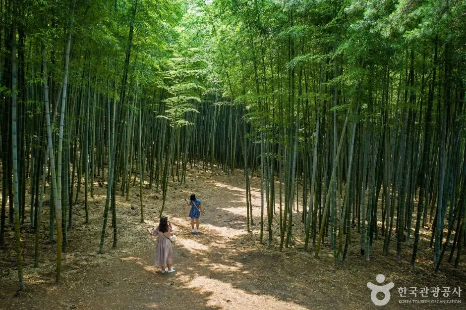
A privately managed forest preserved for roughly four centuries and opened to general visitors in 2016, with bamboo groves and packed-earth woodland paths. Recheck today's opening, admission, final entry and weather before the rural transfer. This catalogue page connects the stop to traveller ratings, current field reports, nearby regional anchors and sourced community corrections.
Help the next traveller understand Ahopsan Forest.
Visitor insight appears after a real contribution, so empty counters never stand in for activity.
Ask a question or share a current update
Recent traveler reports
Answered by travellers, not checked by us. The verified facts above carry the date we confirmed them.
Loading traveller reports…
Questions about this place
Drafts can be restored in this tab and sign-in session for 24 hours. Saving does not post them; expired copies are not automatically deleted.
Question request recovery is not ready. Recheck your account and saved draft before posting.
TODAY AT THIS PLACE
Ask people visiting Ahopsan Forest today.
Each room follows the Seoul calendar day, then becomes a read-only visit record. Share current waits and practical tips without publishing your precise location. Group push notifications stay off during beta.
PLAN THE VISIT
Good to know before you visit
Operator facts are labeled separately from Korea Era estimates and guidance.
A reviewed foundation built from official sources. Traveler edits are checked before publication.
Use the Korean map query attached to this exact pin; do not navigate to a generic Ahopsan peak.
Typical visitCity guide describes roughly one to two hours, not a guaranteed timed courseTransport boundaryGijang village bus 2-3 is listed; verify the live stop and return timetableAccess boundaryPrivate forest rules, closures and staff directions override an old blog routeWeather boundaryPacked earth can be muddy or slippery after rain; heat and insects are seasonalPhoto scopeCurrent hero shows real visitors on a broad packed-earth trail through a bamboo grove
It does not show the ticket desk, every woodland section, parking, toilets, crowding, mud, current closure or final-entry status.
Checked September 1, 2026. Recheck current hours, admission, closures and transport before travel.
Map pinAudited official destination coordinate
The place coordinate is exact; use the named gate, parking area or accessible entrance for the final route.
Mobility checkTrail grade, steps, surface conditions, rest points and step-free alternatives are not assumed; check the official access notice.
DAY-OF PLAN
Know the sequence before you go.
Times from the operator are kept separate from Korea Era planning guidance.
01
Recheck today's opening and admission
The current city guide lists 09:00-18:00, paid admission and on-site parking, but the privately managed forest controls exceptional closure, reservation, final entry and trail access.
02
Use the official entrance and marked route
The forest is private land, not an unrestricted mountain. Follow staff instructions, remain on the open path and keep away from working, restoration or closed areas.
03
Exit before weather or final entry becomes a problem
Packed earth and bamboo shade can remain wet after rain. Allow time for the village-bus or car return rather than beginning a long circuit late.
No. Ahopsan Forest is privately managed, charges admission under the current city guide and can control routes, reservations and closures.
Does the photo prove every trail is open?
No. It documents one real bamboo path only; current route and closure information must come from the operator.
Are the operating details for Ahopsan Forest live?
The displayed guidance was checked September 1, 2026, but it is not a live operator feed. Open the linked official guide and a Korean map again on the day because hours, closures, tickets and transport can change.
Can a traveller correct this page?
Yes. Submit a sourced community wiki correction or a current field report; proposed facts are reviewed before becoming canonical information.
KOREA ERA SHARE
Send this without forcing a sign-up
Public link · Anyone can view
Save this for your Korea tripNo account required during beta.
TRAVELLER CHANNELS
See Ahopsan Forest through a traveler's own post.
Direct links only. Korea Era does not copy the post, imply endorsement or verify live conditions from it.
A privately managed forest preserved for roughly four centuries and opened to general visitors in 2016, with bamboo groves and packed-earth woodland paths. Recheck today's opening, admission, final entry and weather before the rural transfer. This catalogue page connects the stop to traveller ratings, current field reports, nearby regional anchors and sourced community corrections.Recheck the official source before visiting.
Read the full Wiki articleDetailed facts, sources and revision history
KOREA ERA WIKI
TRAVEL KNOWLEDGE DOCUMENT
Ahopsan Forest
아홉산숲A reviewed foundation built from official sources. Traveler edits are checked before publication.
Document statusReviewed foundation5 current facts0 recent approved edits
Global is the shared verified foundation. Country editions add approved local guidance; ratings, discussions and edit histories stay separate.
Showing the shared Global facts and Global edit history.
A privately managed forest preserved for roughly four centuries and opened to general visitors in 2016, with bamboo groves and packed-earth woodland paths. Recheck today's opening, admission, final entry and weather before the rural transfer. This catalogue page connects the stop to traveller ratings, current field reports, nearby regional anchors and sourced community corrections.
37-1 Midong-gil, Cheolma-myeon, Gijang-gunUse the Korean map query attached to this exact pin; do not navigate to a generic Ahopsan peak.
Typical visit
City guide describes roughly one to two hours, not a guaranteed timed course
Transport boundary
Gijang village bus 2-3 is listed; verify the live stop and return timetable
Access boundary
Private forest rules, closures and staff directions override an old blog route
Weather boundary
Packed earth can be muddy or slippery after rain; heat and insects are seasonal
Photo scope
Current hero shows real visitors on a broad packed-earth trail through a bamboo groveIt does not show the ticket desk, every woodland section, parking, toilets, crowding, mud, current closure or final-entry status.
Audited official destination coordinateThe place coordinate is exact; use the named gate, parking area or accessible entrance for the final route.
Mobility check
Trail grade, steps, surface conditions, rest points and step-free alternatives are not assumed; check the official access notice.
3. Visit flow
01
Before the rural transfer
Recheck today's opening and admission
The current city guide lists 09:00-18:00, paid admission and on-site parking, but the privately managed forest controls exceptional closure, reservation, final entry and trail access.
02
At 37-1 Midong-gil
Use the official entrance and marked route
The forest is private land, not an unrestricted mountain. Follow staff instructions, remain on the open path and keep away from working, restoration or closed areas.
03
One to two hours later
Exit before weather or final entry becomes a problem
Packed earth and bamboo shade can remain wet after rain. Allow time for the village-bus or car return rather than beginning a long circuit late.
4. Traveler tips
Wear closed shoes with grip and carry water; the shade does not remove humidity or summer heat.
Save the exact Korean entrance address and return transport before mobile reception becomes unreliable.
Do not touch, cut or leave the trail through bamboo and managed woodland, even for a photograph.
Search “아홉산숲 미동길 37-1” in Naver Map or Kakao Map and confirm the exact entrance and return route.
Recheck weather, trail or garden closures, last entry and seasonal conditions before departure.
The audited coordinate identifies the named destination, but the final gate, parking area and step-free entrance still need a live route check.
No. Ahopsan Forest is privately managed, charges admission under the current city guide and can control routes, reservations and closures.
Does the photo prove every trail is open?
No. It documents one real bamboo path only; current route and closure information must come from the operator.
Are the operating details for Ahopsan Forest live?
The displayed guidance was checked September 1, 2026, but it is not a live operator feed. Open the linked official guide and a Korean map again on the day because hours, closures, tickets and transport can change.
Can a traveller correct this page?
Yes. Submit a sourced community wiki correction or a current field report; proposed facts are reviewed before becoming canonical information.