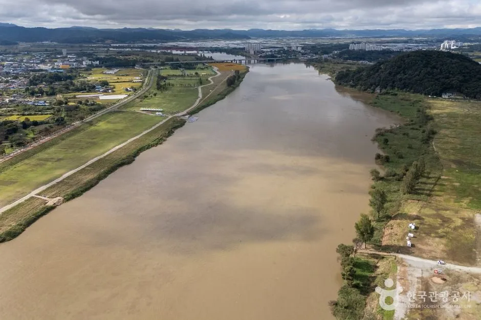
The Geum River stretch framing Buyeo's heritage landscape, with riverside viewpoints and routes spread across several kilometres; pick the exact bank or pier and check heat, flooding and return transport. This catalogue page connects the stop to traveller ratings, current field reports, nearby regional anchors and sourced community corrections.
Each room follows the Seoul calendar day, then becomes a read-only visit record. Share current waits and practical tips without publishing your precise location. Group push notifications stay off during beta.
PLAN THE VISIT
The details that change the day.
Operator facts are labeled separately from Korea Era estimates and guidance.
This address identifies one river-view orientation anchor; it is not the full 24 km trail, a public path promise or a cruise pier.
River-safety boundaryHigh water, flooding and mud override normal route assumptions
Never enter a closed low path or cross a water barrier.
Return transportPlan the final bridge, bus stop, taxi pickup or parked vehicle before starting
A scenic linear route can leave the group far from the original bank.
Cruise boundaryRiver walking and sightseeing boats are separate products
A view of the river does not confirm sailing, fare or the active pier.
Facilities boundaryShade, water, toilets and staffed help vary across the ten sectionsPhoto scopeCurrent hero shows a real broad aerial view of the Baekmagang winding through Buyeo
It does not identify a trail entrance, show live water level or prove every bank is publicly walkable.
Checked September 2, 2026. Recheck current hours, admission, closures and transport before travel.
Map pinAudited official destination coordinate
The place coordinate is exact; use the named gate, parking area or accessible entrance for the final route.
Mobility checkTrail grade, steps, surface conditions, rest points and step-free alternatives are not assumed; check the official access notice.
DAY-OF PLAN
Know the sequence before you go.
Times from the operator are kept separate from Korea Era planning guidance.
01
Choose one river segment
The official Baekmagang trail is 24 km and estimated at about 10 hours across ten sections. A riverside viewpoint visit and the full trail are entirely different plans.
02
Save the exact exit and bridge
The river spans both banks and several kilometres. Confirm the final bus, taxi or parked-car return instead of following the water indefinitely.
03
Check river and path conditions
Flooding, mud, high water, exposed heat and maintenance can close low paths even when the river landscape remains visible.
No. The official full route is 24 km and estimated at about 10 hours. Choose one named section for a casual visit.
Does this map pin show the cruise departure?
No. It represents the river landscape. Use the separate cruise record and confirm the active pier directly.
Are the operating details for Baekmagang River live?
The displayed guidance was checked September 2, 2026, but it is not a live operator feed. Open the linked official guide and a Korean map again on the day because hours, closures, tickets and transport can change.
Can a traveller correct this page?
Yes. Submit a sourced community wiki correction or a current field report; proposed facts are reviewed before becoming canonical information.
KOREA ERA SHARE
Send this without forcing a sign-up
Public link · Anyone can view
Save this for your Korea tripNo account required during beta.
TRAVELLER CHANNELS
See Baekmagang River through a traveler's own post.
Direct links only. Korea Era does not copy the post, imply endorsement or verify live conditions from it.
The Geum River stretch framing Buyeo's heritage landscape, with riverside viewpoints and routes spread across several kilometres; pick the exact bank or pier and check heat, flooding and return transport. This catalogue page connects the stop to traveller ratings, current field reports, nearby regional anchors and sourced community corrections.Recheck the official source before visiting.
Read the full Wiki articleDetailed facts, sources and revision history
KOREA ERA WIKI
TRAVEL KNOWLEDGE DOCUMENT
Baekmagang River
백마강A reviewed foundation built from official sources. Traveler edits are checked before publication.
Document statusReviewed foundation4 current facts0 approved edits
Global is the shared verified foundation. Country editions add approved local guidance; ratings, discussions and edit histories stay separate.
Showing the shared Global facts and Global edit history.
The Geum River stretch framing Buyeo's heritage landscape, with riverside viewpoints and routes spread across several kilometres; pick the exact bank or pier and check heat, flooding and return transport. This catalogue page connects the stop to traveller ratings, current field reports, nearby regional anchors and sourced community corrections.
High water, flooding and mud override normal route assumptionsNever enter a closed low path or cross a water barrier.
Return transport
Plan the final bridge, bus stop, taxi pickup or parked vehicle before startingA scenic linear route can leave the group far from the original bank.
Cruise boundary
River walking and sightseeing boats are separate productsA view of the river does not confirm sailing, fare or the active pier.
Facilities boundary
Shade, water, toilets and staffed help vary across the ten sections
Photo scope
Current hero shows a real broad aerial view of the Baekmagang winding through BuyeoIt does not identify a trail entrance, show live water level or prove every bank is publicly walkable.
Buyeo County Tourism · Baekmagang walking route · catalogue checked August 26, 2026Checked 1/1/2026 · Korea Era editors · source
3. Visit flow
01
Before walking
Choose one river segment
The official Baekmagang trail is 24 km and estimated at about 10 hours across ten sections. A riverside viewpoint visit and the full trail are entirely different plans.
02
At the chosen bank
Save the exact exit and bridge
The river spans both banks and several kilometres. Confirm the final bus, taxi or parked-car return instead of following the water indefinitely.
03
After heavy rain or in summer heat
Check river and path conditions
Flooding, mud, high water, exposed heat and maintenance can close low paths even when the river landscape remains visible.
4. Traveler tips
For a first visit, choose the Busosan-Gudurae riverside area instead of attempting the entire 24 km course.
Download the chosen segment and return route before leaving the town centre because riverside reception and wayfinding can vary.
Carry sun protection and water; exposed river paths can feel much hotter than shaded fortress trails.
Search “충청남도 부여군 규암면 백제문로 553 백마강” in Naver Map or Kakao Map and confirm the exact entrance and return route.
Recheck weather, trail or garden closures, last entry and seasonal conditions before departure.
The audited coordinate identifies the named destination, but the final gate, parking area and step-free entrance still need a live route check.
No. The official full route is 24 km and estimated at about 10 hours. Choose one named section for a casual visit.
Does this map pin show the cruise departure?
No. It represents the river landscape. Use the separate cruise record and confirm the active pier directly.
Are the operating details for Baekmagang River live?
The displayed guidance was checked September 2, 2026, but it is not a live operator feed. Open the linked official guide and a Korean map again on the day because hours, closures, tickets and transport can change.
Can a traveller correct this page?
Yes. Submit a sourced community wiki correction or a current field report; proposed facts are reviewed before becoming canonical information.