An active historic temple at the Naeyeonsan municipal-park entrance; the current park baseline is 06:00–18:00 and year-round subject to weather controls, but temple worship, protected halls, the 12-waterfall trail, bridge and mountain route remain separate access and safety decisions. This catalogue page connects the stop to traveller ratings, current field reports, nearby regional anchors and sourced community corrections.
Each room follows the Seoul calendar day, then becomes a read-only visit record. Share current waits and practical tips without publishing your precise location. Group push notifications stay off during beta.
PLAN THE VISIT
The details that change the day.
Operator facts are labeled separately from Korea Era estimates and guidance.
RegionPohang · GyeongbukKorean map search보경사 경상북도 포항시 북구 송라면 보경로 523Current park baseline06:00–18:00 · year-round subject to weather ↗Exact destination523 Bogyeong-ro, Songna-myeon, Buk-gu, Pohang
This is the temple and municipal-park entrance, not one of the upper waterfall coordinates.
Worship boundaryActive Buddhist temple with protected and residential space
An open gate does not unlock every hall or permit entry during worship.
Route boundaryTemple visit and 12-waterfall trail are separate products
Choose a named waterfall or signed route and turn back for weather, fatigue or low light.
Water boundaryNo swimming, diving or improvised stream crossing
Upstream rain can change flow quickly even when it is dry at the entrance.
Heritage boundaryDo not touch, rub, climb or stage props against protected fabric
Ask before organised, tripod or commercial photography.
Transport boundaryProtect the rural bus or lawful parking return
Mountain-road congestion and a longer-than-planned trail can remove the last practical connection.
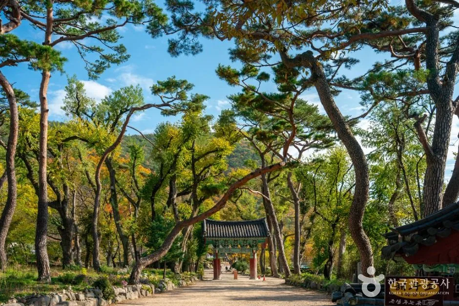
Photo scopeThe reviewed hero is a real tree-lined approach to a traditional tiled gate within Bogyeongsa Temple
It does not prove today's park gate, unlocked hall, ceremony access, safe waterfall trail, dry bridge, low stream, available bus, parking vacancy or complete step-free route.
Checked September 1, 2026. Recheck current hours, admission, closures and transport before travel.
Map pinAudited official destination coordinate
The place coordinate is exact; use the named gate, parking area or accessible entrance for the final route.
Mobility checkConfirm the current step-free entrance, lift availability, rest areas and accessible toilets with the venue.
DAY-OF PLAN
Know the sequence before you go.
Times from the operator are kept separate from Korea Era planning guidance.
01
Choose temple grounds or a named waterfall route
Bogyeongsa is an active temple at the municipal-park entrance. A temple visit, Sangsaeng Falls walk, Yeonsan Falls route and longer Naeyeonsan hike need different time, equipment and turnaround decisions.
02
Enter within the current municipal-park span
The park record lists year-round operation subject to weather controls. Worship, individual halls and monastic space remain separate from the park gate.
03
Set the waterfall turnaround
Check rain, flood, bridge, rockfall, heat, ice and daylight. Do not continue because another group is ahead or because the temple itself is open.
Does an open temple mean the waterfall trail is safe?
No. Temple access and mountain-trail safety are separate. Rain, flood, bridge, rock, ice, heat and daylight can close or shorten the waterfall route.
Can I enter every temple hall during the park hours?
No. The park span does not open protected, ceremonial or residential temple space. Follow doors, barriers and monastic instructions.
Are the operating details for Bogyeongsa Temple live?
The displayed guidance was checked September 1, 2026, but it is not a live operator feed. Open the linked official guide and a Korean map again on the day because hours, closures, tickets and transport can change.
Can a traveller correct this page?
Yes. Submit a sourced community wiki correction or a current field report; proposed facts are reviewed before becoming canonical information.
KOREA ERA SHARE
Send this without forcing a sign-up
Public link · Anyone can view
Save this for your Korea tripNo account required during beta.
TRAVELLER CHANNELS
See Bogyeongsa Temple through a traveler's own post.
Direct links only. Korea Era does not copy the post, imply endorsement or verify live conditions from it.
An active historic temple at the Naeyeonsan municipal-park entrance; the current park baseline is 06:00–18:00 and year-round subject to weather controls, but temple worship, protected halls, the 12-waterfall trail, bridge and mountain route remain separate access and safety decisions. This catalogue page connects the stop to traveller ratings, current field reports, nearby regional anchors and sourced community corrections.Recheck the official source before visiting.
Read the full Wiki articleDetailed facts, sources and revision history
KOREA ERA WIKI
TRAVEL KNOWLEDGE DOCUMENT
Bogyeongsa Temple
보경사A reviewed foundation built from official sources. Traveler edits are checked before publication.
Document statusReviewed foundation4 current facts0 approved edits
Global is the shared verified foundation. Country editions add approved local guidance; ratings, discussions and edit histories stay separate.
Showing the shared Global facts and Global edit history.
An active historic temple at the Naeyeonsan municipal-park entrance; the current park baseline is 06:00–18:00 and year-round subject to weather controls, but temple worship, protected halls, the 12-waterfall trail, bridge and mountain route remain separate access and safety decisions. This catalogue page connects the stop to traveller ratings, current field reports, nearby regional anchors and sourced community corrections.
523 Bogyeong-ro, Songna-myeon, Buk-gu, PohangThis is the temple and municipal-park entrance, not one of the upper waterfall coordinates.
Worship boundary
Active Buddhist temple with protected and residential spaceAn open gate does not unlock every hall or permit entry during worship.
Route boundary
Temple visit and 12-waterfall trail are separate productsChoose a named waterfall or signed route and turn back for weather, fatigue or low light.
Water boundary
No swimming, diving or improvised stream crossingUpstream rain can change flow quickly even when it is dry at the entrance.
Heritage boundary
Do not touch, rub, climb or stage props against protected fabricAsk before organised, tripod or commercial photography.
Transport boundary
Protect the rural bus or lawful parking returnMountain-road congestion and a longer-than-planned trail can remove the last practical connection.
Photo scope
The reviewed hero is a real tree-lined approach to a traditional tiled gate within Bogyeongsa TempleIt does not prove today's park gate, unlocked hall, ceremony access, safe waterfall trail, dry bridge, low stream, available bus, parking vacancy or complete step-free route.
Audited official destination coordinateThe place coordinate is exact; use the named gate, parking area or accessible entrance for the final route.
Mobility check
Confirm the current step-free entrance, lift availability, rest areas and accessible toilets with the venue.
Approved current facts
Transit
Korean map search · 보경사 경상북도 포항시 북구 송라면 보경로 523Checked 1/1/2026 · Korea Era editors · source
Official links
VISITKOREA · Bogyeongsa Temple · catalogue checked August 26, 2026Checked 1/1/2026 · Korea Era editors · source
3. Visit flow
01
Before travel
Choose temple grounds or a named waterfall route
Bogyeongsa is an active temple at the municipal-park entrance. A temple visit, Sangsaeng Falls walk, Yeonsan Falls route and longer Naeyeonsan hike need different time, equipment and turnaround decisions.
02
06:00–18:00 park baseline
Enter within the current municipal-park span
The park record lists year-round operation subject to weather controls. Worship, individual halls and monastic space remain separate from the park gate.
03
Before leaving the temple precinct
Set the waterfall turnaround
Check rain, flood, bridge, rockfall, heat, ice and daylight. Do not continue because another group is ahead or because the temple itself is open.
4. Traveler tips
Save 보경사 and the intended waterfall separately; a generic Naeyeonsan pin is not a trail plan.
Keep voices low and photograph worshippers only with consent before starting the mountain route.
Turn around conservatively for thunder, rising water, ice or fading light regardless of the published park closing time.
Search “보경사 경상북도 포항시 북구 송라면 보경로 523” in Naver Map or Kakao Map and confirm the exact entrance and return route.
Hours, admission, closures and programme schedules can change; use the official source before departure.
The audited coordinate identifies the named destination, but the final gate, parking area and step-free entrance still need a live route check.
Does an open temple mean the waterfall trail is safe?
No. Temple access and mountain-trail safety are separate. Rain, flood, bridge, rock, ice, heat and daylight can close or shorten the waterfall route.
Can I enter every temple hall during the park hours?
No. The park span does not open protected, ceremonial or residential temple space. Follow doors, barriers and monastic instructions.
Are the operating details for Bogyeongsa Temple live?
The displayed guidance was checked September 1, 2026, but it is not a live operator feed. Open the linked official guide and a Korean map again on the day because hours, closures, tickets and transport can change.
Can a traveller correct this page?
Yes. Submit a sourced community wiki correction or a current field report; proposed facts are reviewed before becoming canonical information.