Korea Era← Discover Korea Era
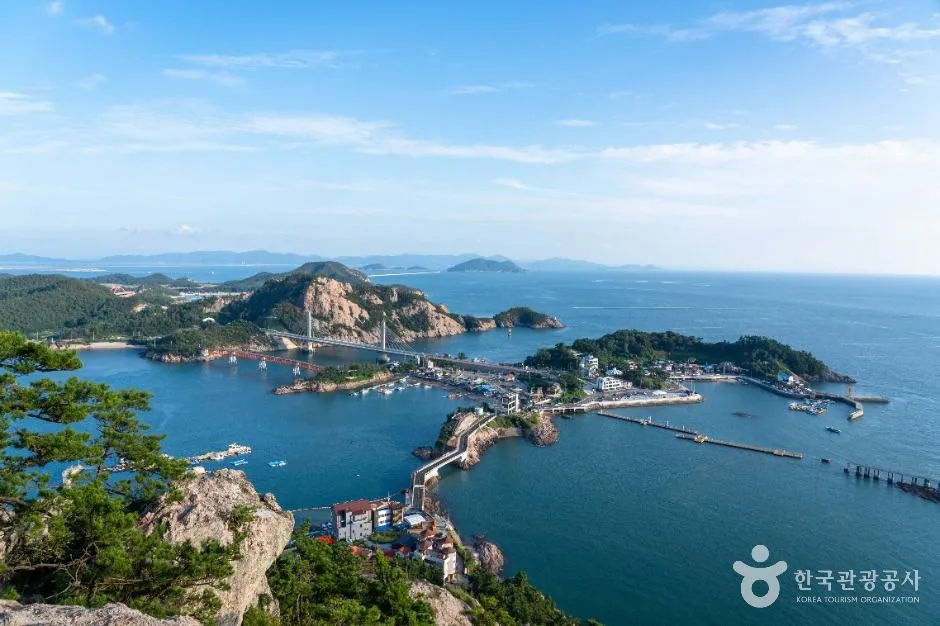
The island harbour and Gogunsan coast viewed from Daejangbong Observatory
Representative venue or area photo—not an event poster. Photo: © Korea Tourism Organization · TourAPI content 2948095 · hero image · Korea Open Government License Type 1 · resized
Place guide

Hot places · Gunsan · Jeonbuk

Daejangbong Observatory

대장봉 전망대

A steep stair-and-rock ascent above Daejangdo with a wide panorama over Seonyudo, Munyeodo, Sinsido and the Gogunsan islands; the exact summit-viewpoint pin is not a vehicle arrival, so use proper footwear and avoid the exposed climb in rain, ice, heat or strong wind. This catalogue page connects the stop to traveller ratings, current field reports, nearby regional anchors and sourced community corrections.

Share your visitRating and practical review

OFFICIAL INFORMATION

Useful facts, with the source still attached.

Status
Place guide
Dates
Ongoing place guide
Area
Gunsan · Jeonbuk
Transit
Korean map search · 전북특별자치도 군산시 옥도면 대장도리 대장봉 전망대
Source check
Not yet verified
OFFICIAL SOURCEVISITKOREA · Daejangbong Observatory · catalogue checked August 26, 2026

Korea Era keeps the original source visible so you can verify details before leaving.

Open official details ↗

TRAVELLER INSIGHT

Help the next traveller understand Daejangbong Observatory.

Visitor insight appears after a real contribution, so empty counters never stand in for activity.
Ask a question or share a current update

Recent traveler reports

Answered by travellers, not checked by us. The verified facts above carry the date we confirmed them.

Loading traveller reports…

Questions about this place

    TODAY AT THIS PLACE

    Ask people visiting Daejangbong Observatory today.

    Each room follows the Seoul calendar day, then becomes a read-only visit record. Share current waits and practical tips without publishing your precise location. Group push notifications stay off during beta.

    PLAN THE VISIT

    Good to know before you visit

    Operator facts are labeled separately from Korea Era estimates and guidance.

    A reviewed foundation built from official sources. Traveler edits are checked before publication.

    RegionGunsan · Jeonbuk
    Korean map search전북특별자치도 군산시 옥도면 대장도리 대장봉 전망대
    Exact viewpointPublished summit coordinate in Daejangdo-ri, Okdo-myeon

    Navigate to a legal visitor arrival and use signed foot access.

    Route characterSteep stair-and-rock ascent

    This is not a roadside observatory.

    Weather boundaryWind, rain, ice, heat and visibility decide the climb

    Turn back when footing or exposure is unsafe.

    Mobility realityThe summit route is not step-free

    Choose a lower island viewpoint when stairs or rock are unsuitable.

    Photo scopeReal panorama of the harbour and Gogunsan islands from Daejangbong

    The static frame does not prove today's visibility or route safety.

    Map pinAudited official destination coordinate

    The place coordinate is exact; use the named gate, parking area or accessible entrance for the final route.

    Mobility checkSlopes, boardwalk gaps, rocks, sand, wind and boarding conditions can change the usable route; confirm before travelling.

    DAY-OF PLAN

    Know the sequence before you go.

    Times from the operator are kept separate from Korea Era planning guidance.
    1. 01
      Check wind, rain, heat and visibility

      The exposed summit route is not worth forcing in slippery, icy, stormy or low-visibility conditions.

    2. 02
      Follow the signed climb, not the summit pin alone

      The audited coordinate identifies the viewpoint; it is not a car park or promise of a step-free arrival.

    3. 03
      Descend with full light and return transport protected

      Steep stairs and rock require more care downhill, especially when island roads and buses are busy.

    MAKE A HALF-DAY OF IT

    Nearby, without another search spiral.

    TRAVELER FAQ

    Answers worth checking before you leave.

    Can I drive to the viewpoint pin?

    No. The coordinate marks the summit viewpoint, not a vehicle arrival. Use legal island parking and the signed walking approach.

    Is the climb suitable in rain or strong wind?

    Treat wet rock, ice and strong wind as reasons to choose a lower viewpoint. Live conditions override the catalogue.

    Are the operating details for Daejangbong Observatory live?

    The displayed guidance was checked September 8, 2026, but it is not a live operator feed. Open the linked official guide and a Korean map again on the day because hours, closures, tickets and transport can change.

    Can a traveller correct this page?

    Yes. Submit a sourced community wiki correction or a current field report; proposed facts are reviewed before becoming canonical information.

    ABOUT · KOREA ERA WIKI

    About Daejangbong Observatory

    A steep stair-and-rock ascent above Daejangdo with a wide panorama over Seonyudo, Munyeodo, Sinsido and the Gogunsan islands; the exact summit-viewpoint pin is not a vehicle arrival, so use proper footwear and avoid the exposed climb in rain, ice, heat or strong wind. This catalogue page connects the stop to traveller ratings, current field reports, nearby regional anchors and sourced community corrections.Recheck the official source before visiting.
    Read the full Wiki articleDetailed facts, sources and revision history
    KOREA ERA WIKI

    TRAVEL KNOWLEDGE DOCUMENT

    Daejangbong Observatory

    대장봉 전망대A reviewed foundation built from official sources. Traveler edits are checked before publication.
    Document statusReviewed foundation4 current facts0 recent approved edits

    Global is the shared verified foundation. Country editions add approved local guidance; ratings, discussions and edit histories stay separate.

    Showing the shared Global facts and Global edit history.

    Contents
    1. 1Overview
    2. 2Key facts and visitor information
    3. 3Visit flow
    4. 4Traveler tips
    5. 5Nearby places
    6. 6Frequently asked questions
    7. 7Sources and revision history

    1. Overview

    A steep stair-and-rock ascent above Daejangdo with a wide panorama over Seonyudo, Munyeodo, Sinsido and the Gogunsan islands; the exact summit-viewpoint pin is not a vehicle arrival, so use proper footwear and avoid the exposed climb in rain, ice, heat or strong wind. This catalogue page connects the stop to traveller ratings, current field reports, nearby regional anchors and sourced community corrections.

    2. Key facts and visitor information

    RegionGunsan · Jeonbuk
    Korean map search전북특별자치도 군산시 옥도면 대장도리 대장봉 전망대
    Exact viewpointPublished summit coordinate in Daejangdo-ri, Okdo-myeonNavigate to a legal visitor arrival and use signed foot access.
    Route characterSteep stair-and-rock ascentThis is not a roadside observatory.
    Weather boundaryWind, rain, ice, heat and visibility decide the climbTurn back when footing or exposure is unsafe.
    Mobility realityThe summit route is not step-freeChoose a lower island viewpoint when stairs or rock are unsuitable.
    Photo scopeReal panorama of the harbour and Gogunsan islands from DaejangbongThe static frame does not prove today's visibility or route safety.
    Current official guideVISITKOREA · Daejangbong ObservatoryChecked September 8, 2026. Recheck current hours, admission, closures and transport before travel.
    Map pinAudited official destination coordinateThe place coordinate is exact; use the named gate, parking area or accessible entrance for the final route.
    Mobility checkSlopes, boardwalk gaps, rocks, sand, wind and boarding conditions can change the usable route; confirm before travelling.

    3. Visit flow

    1. 01
      Before crossing to the islands

      Check wind, rain, heat and visibility

      The exposed summit route is not worth forcing in slippery, icy, stormy or low-visibility conditions.

    2. 02
      From the Daejangdo side

      Follow the signed climb, not the summit pin alone

      The audited coordinate identifies the viewpoint; it is not a car park or promise of a step-free arrival.

    3. 03
      Before sunset

      Descend with full light and return transport protected

      Steep stairs and rock require more care downhill, especially when island roads and buses are busy.

    4. Traveler tips

    • Wear secure walking shoes and keep both hands available on steep or exposed sections.
    • Carry water and sun protection; the short map distance understates heat and vertical effort.
    • Use Seonyudo's lower coast as the fallback when wind, rain or mobility makes the summit inappropriate.
    • Search “전북특별자치도 군산시 옥도면 대장도리 대장봉 전망대” in Naver Map or Kakao Map and confirm the exact entrance and return route.
    • Check rain, wind, waves and any access or transport notice on the day.
    • The audited coordinate identifies the named destination, but the final gate, parking area and step-free entrance still need a live route check.

    5. Nearby places

    6. Frequently asked questions

    Can I drive to the viewpoint pin?

    No. The coordinate marks the summit viewpoint, not a vehicle arrival. Use legal island parking and the signed walking approach.

    Is the climb suitable in rain or strong wind?

    Treat wet rock, ice and strong wind as reasons to choose a lower viewpoint. Live conditions override the catalogue.

    Are the operating details for Daejangbong Observatory live?

    The displayed guidance was checked September 8, 2026, but it is not a live operator feed. Open the linked official guide and a Korean map again on the day because hours, closures, tickets and transport can change.

    Can a traveller correct this page?

    Yes. Submit a sourced community wiki correction or a current field report; proposed facts are reviewed before becoming canonical information.

    7. Sources and revision history

    Foundation sourceVISITKOREA · Daejangbong Observatory · catalogue checked August 26, 2026 ↗Recheck time-sensitive hours, prices and reservation rules on the official page.
    Loading approved history

    Loading revision history.

    Share a 10-second update

    LAST 48 HOURS · TRAVELLER REPORTS

    Share a current update from this place.

    A quick open, crowd and payment check helps the next traveller.

    Loading visitor reports…

    Sharing is paused while we check your account.

    TRAVELLER RATINGS

    Would you make this stop again?

    Sign in to leave a rating or review. Share useful tips in your review, or keep the whole story and your photos in a travel log.
    Record your visit →
    Rate or review this place

    Published traveler reviews

    Up to 20 featured reviews are shown here. Open the published history to read older reviews.

    Travel context and photo filters apply only to loaded reviews, not the entire history.

    Sign in to write a reviewYour review can include a visit date and up to four photos.