A wooded urban mountain with neighbourhood trailheads, ridge paths and views over southern Seoul, suitable for a short nature break from the Gangnam business districts; the park is always open and parking exists at selected approaches, but trail grade, mud, ice and lighting vary, so choose the correct trailhead, carry water and finish before dark. This catalogue page connects the stop to traveller ratings, current field reports, nearby regional anchors and sourced community corrections.
Ask people visiting Daemosan Urban Nature Park today.
Each room follows the Seoul calendar day, then becomes a read-only visit record. Share current waits and practical tips without publishing your precise location. Group push notifications stay off during beta.
PLAN THE VISIT
The details that change the day.
Operator facts are labeled separately from Korea Era estimates and guidance.
RegionGangnam-gu · SeoulKorean map search대모산도시자연공원Mountain height293 m ↗Route choiceSummit route · lower-gradient Jarak-gil · ridge or perimeter pathsGangnam Trail Course 37.2 km · about 180 minutes · walking only ↗
This is a separate district traverse, not the minimum Daemosan visit.
Jarak-gil boundaryLower gradient does not make every mountain path step-free
Confirm the exact entrance, surface, slope, rest points and exit for the traveller.
Weather boundaryRain, ice, heat, wind, fire controls and maintenance can change safe accessFacilitiesPublic toilets listed at the trail entrance and Dalteo Neighborhood Park
Do not assume a toilet, water or staffed facility at every trailhead.
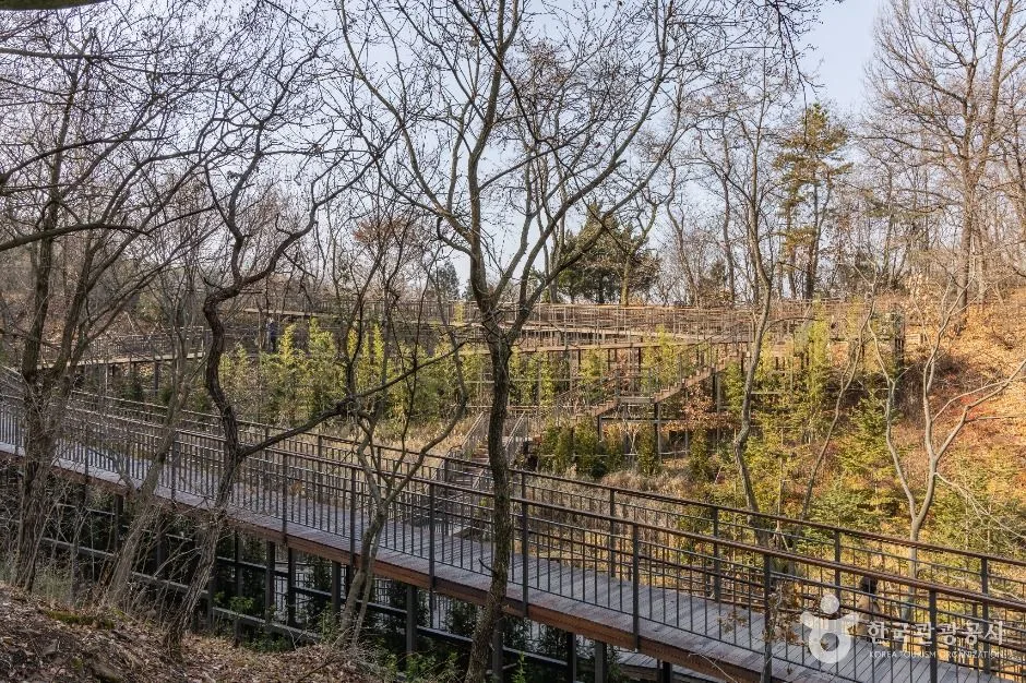
Bicycle boundaryGangnam Trail Course 3 is walking-onlyPhoto scopeCurrent hero shows a real elevated wooden woodland boardwalk during a leafless season
It does not show the summit, current foliage, entire Jarak-gil accessibility, dry surface, open lookout or daylight remaining.
Checked August 29, 2026. Recheck current hours, admission, closures and transport before travel.
Map pinApproximate catalogue centre
Use a Korean map app for the exact entrance and final walking route.
Mobility checkTrail grade, steps, surface conditions, rest points and step-free alternatives are not assumed; check the official access notice.
DAY-OF PLAN
Know the sequence before you go.
Times from the operator are kept separate from Korea Era planning guidance.
01
Choose summit, Jarak-gil or the full district course
The current district guide describes the summit at roughly three kilometres from its trail context, while Gangnam Trail Course 3 is a separate 7.2-kilometre, approximately 180-minute one-way district route from Heolleung IC through Daemosan to Yangjaecheon. Save the exact trailhead and finish.
02
Read live surface and access notices
The 2021 lower-gradient Jarak-gil improves access for many visitors, but it does not make every ridge, stair, lookout or connector step-free. Check mud, ice, heat, wind, works and toilet availability before committing.
03
Turn around with a lit return
General park access is not a promise of trail lighting, staffed rescue or late transit. Carry water and offline navigation and leave the woodland before darkness rather than using an always-open listing as a night-hike recommendation.
Is the whole Daemosan route accessible because Jarak-gil is lower-gradient?
No. Jarak-gil is one improved route. Ridge paths, stairs, lookouts and connectors can still have grades and surfaces that require a separate mobility check.
Is the 7.2-kilometre Course 3 the only way to visit Daemosan?
No. It is a longer district trail that crosses Daemosan. Choose a specific summit, Jarak-gil or neighbourhood loop when a shorter visit is intended.
Are the operating details for Daemosan Urban Nature Park live?
The displayed guidance was checked August 29, 2026, but it is not a live operator feed. Open the linked official guide and a Korean map again on the day because hours, closures, tickets and transport can change.
Can a traveller correct this page?
Yes. Submit a sourced community wiki correction or a current field report; proposed facts are reviewed before becoming canonical information.
KOREA ERA SHARE
Send this without forcing a sign-up
Public link · Anyone can view
Save this for your Korea tripNo account required during beta.
TRAVELLER CHANNELS
See Daemosan Urban Nature Park through a traveler's own post.
Direct links only. Korea Era does not copy the post, imply endorsement or verify live conditions from it.
A wooded urban mountain with neighbourhood trailheads, ridge paths and views over southern Seoul, suitable for a short nature break from the Gangnam business districts; the park is always open and parking exists at selected approaches, but trail grade, mud, ice and lighting vary, so choose the correct trailhead, carry water and finish before dark. This catalogue page connects the stop to traveller ratings, current field reports, nearby regional anchors and sourced community corrections.Recheck the official source before visiting.
Read the full Wiki articleDetailed facts, sources and revision history
KOREA ERA WIKI
TRAVEL KNOWLEDGE DOCUMENT
Daemosan Urban Nature Park
대모산도시자연공원A reviewed foundation built from official sources. Traveler edits are checked before publication.
Document statusReviewed foundation4 current facts0 approved edits
Global is the shared verified foundation. Country editions add approved local guidance; ratings, discussions and edit histories stay separate.
Showing the shared Global facts and Global edit history.
A wooded urban mountain with neighbourhood trailheads, ridge paths and views over southern Seoul, suitable for a short nature break from the Gangnam business districts; the park is always open and parking exists at selected approaches, but trail grade, mud, ice and lighting vary, so choose the correct trailhead, carry water and finish before dark. This catalogue page connects the stop to traveller ratings, current field reports, nearby regional anchors and sourced community corrections.
Lower gradient does not make every mountain path step-freeConfirm the exact entrance, surface, slope, rest points and exit for the traveller.
Weather boundary
Rain, ice, heat, wind, fire controls and maintenance can change safe access
Facilities
Public toilets listed at the trail entrance and Dalteo Neighborhood ParkDo not assume a toilet, water or staffed facility at every trailhead.
Bicycle boundary
Gangnam Trail Course 3 is walking-only
Photo scope
Current hero shows a real elevated wooden woodland boardwalk during a leafless seasonIt does not show the summit, current foliage, entire Jarak-gil accessibility, dry surface, open lookout or daylight remaining.
VISITKOREA · Daemosan Urban Nature Park · catalogue checked August 26, 2026Checked 1/1/2026 · Korea Era editors · source
3. Visit flow
01
Before setting a route
Choose summit, Jarak-gil or the full district course
The current district guide describes the summit at roughly three kilometres from its trail context, while Gangnam Trail Course 3 is a separate 7.2-kilometre, approximately 180-minute one-way district route from Heolleung IC through Daemosan to Yangjaecheon. Save the exact trailhead and finish.
02
At the trailhead
Read live surface and access notices
The 2021 lower-gradient Jarak-gil improves access for many visitors, but it does not make every ridge, stair, lookout or connector step-free. Check mud, ice, heat, wind, works and toilet availability before committing.
03
Well before sunset
Turn around with a lit return
General park access is not a promise of trail lighting, staffed rescue or late transit. Carry water and offline navigation and leave the woodland before darkness rather than using an always-open listing as a night-hike recommendation.
4. Traveler tips
Send the Korean trailhead pin and intended exit to the group before entering; the broad Daemosan centre pin is not a navigable entrance.
Use grippy footwear even for the boardwalk because leaves, frost and wet timber can be slippery and the route may connect to natural trail.
Do not drink from a spring unless the current official test notice explicitly marks it potable; carry enough water instead.
Search “대모산도시자연공원” in Naver Map or Kakao Map and confirm the exact entrance and return route.
Recheck weather, trail or garden closures, last entry and seasonal conditions before departure.
The catalogue coordinate is an approximate centre pin, not turn-by-turn entrance guidance.
Is the whole Daemosan route accessible because Jarak-gil is lower-gradient?
No. Jarak-gil is one improved route. Ridge paths, stairs, lookouts and connectors can still have grades and surfaces that require a separate mobility check.
Is the 7.2-kilometre Course 3 the only way to visit Daemosan?
No. It is a longer district trail that crosses Daemosan. Choose a specific summit, Jarak-gil or neighbourhood loop when a shorter visit is intended.
Are the operating details for Daemosan Urban Nature Park live?
The displayed guidance was checked August 29, 2026, but it is not a live operator feed. Open the linked official guide and a Korean map again on the day because hours, closures, tickets and transport can change.
Can a traveller correct this page?
Yes. Submit a sourced community wiki correction or a current field report; proposed facts are reviewed before becoming canonical information.