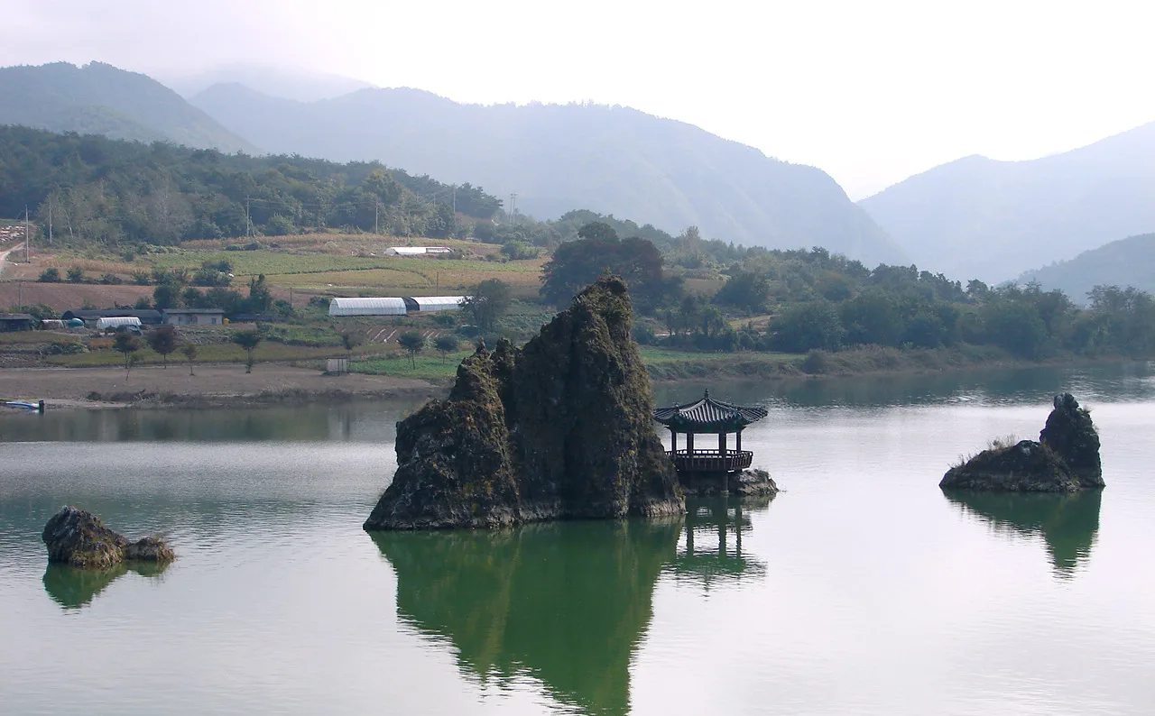
Three rock peaks rising from the Namhan River beside a managed viewpoint area; daylight, river level, boat operation, parking and nearby Seokmun trail access vary independently. This catalogue page connects the stop to traveller ratings, current field reports, nearby regional anchors and sourced community corrections.
Each room follows the Seoul calendar day, then becomes a read-only visit record. Share current waits and practical tips without publishing your precise location. Group push notifications stay off during beta.
PLAN THE VISIT
The details that change the day.
Operator facts are labeled separately from Korea Era estimates and guidance.
A live facility, event, weather, safety or conservation notice can still override the published baseline.
Exact arrival644 Sambong-ro, Maepo-eup, Danyang-gun, Chungcheongbuk-doMap pinAudited TourAPI coordinate at Dodamsambong Peaks's published visitor point
One coordinate does not guarantee the closest entrance, parking bay or step-free route.
LandscapeThree rocky peaks rise from the Namhan River; the central peak carries a small pavilionFacility boundaryBoat rides, parking, shops and nearby trail access are separate from the public viewRiver boundaryWater level, current, fog and safety barriers can change the usable edge and viewSeokmun boundaryThe nearby stone-gate route requires its own trail, weather, footwear and daylight checkVisitor boundaryGeneral landscape access does not keep boats, shops, parking services or the nearby Seokmun route open.ParkingParking is listed as available
Capacity, charges, accessible bays and event traffic require an on-arrival check.
Photo scopeThe current hero shows the real three rocky Dodamsambong peaks in the Namhan River with the central pavilion
It does not prove today's river level, boat operation, trail access, visibility, parking or crowd level.
Checked September 8, 2026. Recheck current hours, admission, closures and transport before travel.
Map pinAudited official destination coordinate
The place coordinate is exact; use the named gate, parking area or accessible entrance for the final route.
Mobility checkTrail grade, steps, surface conditions, rest points and step-free alternatives are not assumed; check the official access notice.
DAY-OF PLAN
Know the sequence before you go.
Times from the operator are kept separate from Korea Era planning guidance.
01
Check the viewpoint, boat and nearby trail separately
The river peaks remain visible from the managed area, but boats, parking, food businesses and the route toward Seokmun use their own operation and safety decisions.
02
Use the public viewpoint for the three-peak composition
Stay behind river-edge controls and keep the central pavilion and all three rock peaks in view without entering the water or climbing protected rock.
03
Finish any paid facility before the landscape stop
A visible river does not keep the boat, parking office, shop or trail open. Confirm the final service before extending the visit.
Does the map pin guarantee the exact entrance and parking space?
No. It is the audited published visitor coordinate; use current signs and staff directions for the final approach.
Does the listed access mean every facility is open?
No. General landscape access does not keep boats, shops, parking services or the nearby Seokmun route open.
Can I rely on the photograph for today's conditions?
No. It does not prove today's river level, boat operation, trail access, visibility, parking or crowd level.
Should I recheck before making a dedicated trip?
Yes. Recheck the linked current record, weather and the named operator for any paid, seasonal or staffed facility.
Are the operating details for Dodamsambong Peaks live?
The displayed guidance was checked September 8, 2026, but it is not a live operator feed. Open the linked official guide and a Korean map again on the day because hours, closures, tickets and transport can change.
Can a traveller correct this page?
Yes. Submit a sourced community wiki correction or a current field report; proposed facts are reviewed before becoming canonical information.
KOREA ERA SHARE
Send this without forcing a sign-up
Public link · Anyone can view
Save this for your Korea tripNo account required during beta.
TRAVELLER CHANNELS
See Dodamsambong Peaks through a traveler's own post.
Direct links only. Korea Era does not copy the post, imply endorsement or verify live conditions from it.
Three rock peaks rising from the Namhan River beside a managed viewpoint area; daylight, river level, boat operation, parking and nearby Seokmun trail access vary independently. This catalogue page connects the stop to traveller ratings, current field reports, nearby regional anchors and sourced community corrections.Recheck the official source before visiting.
Read the full Wiki articleDetailed facts, sources and revision history
KOREA ERA WIKI
TRAVEL KNOWLEDGE DOCUMENT
Dodamsambong Peaks
도담삼봉A reviewed foundation built from official sources. Traveler edits are checked before publication.
Document statusReviewed foundation6 current facts0 approved edits
Global is the shared verified foundation. Country editions add approved local guidance; ratings, discussions and edit histories stay separate.
Showing the shared Global facts and Global edit history.
Three rock peaks rising from the Namhan River beside a managed viewpoint area; daylight, river level, boat operation, parking and nearby Seokmun trail access vary independently. This catalogue page connects the stop to traveller ratings, current field reports, nearby regional anchors and sourced community corrections.
Listed open year-round; river, weather and facility notices can overrideA live facility, event, weather, safety or conservation notice can still override the published baseline.
Audited TourAPI coordinate at Dodamsambong Peaks's published visitor pointOne coordinate does not guarantee the closest entrance, parking bay or step-free route.
Landscape
Three rocky peaks rise from the Namhan River; the central peak carries a small pavilion
Facility boundary
Boat rides, parking, shops and nearby trail access are separate from the public view
River boundary
Water level, current, fog and safety barriers can change the usable edge and view
Seokmun boundary
The nearby stone-gate route requires its own trail, weather, footwear and daylight check
Visitor boundary
General landscape access does not keep boats, shops, parking services or the nearby Seokmun route open.
Parking
Parking is listed as availableCapacity, charges, accessible bays and event traffic require an on-arrival check.
Photo scope
The current hero shows the real three rocky Dodamsambong peaks in the Namhan River with the central pavilionIt does not prove today's river level, boat operation, trail access, visibility, parking or crowd level.
Published visitor baseline 09:00-18:00; individual facilities can differChecked 1/1/2026 · Korea Era editors · source
Closure or relocation
Listed open year-round; river, weather and facility notices can override
A live facility, event, weather, safety or conservation notice can still override the published baseline.Checked 1/1/2026 · Korea Era editors · source
Official links
VISITKOREA · Dodamsambong Peaks · catalogue checked August 26, 2026Checked 1/1/2026 · Korea Era editors · source
3. Visit flow
01
Before travel
Check the viewpoint, boat and nearby trail separately
The river peaks remain visible from the managed area, but boats, parking, food businesses and the route toward Seokmun use their own operation and safety decisions.
02
At 644 Sambong-ro
Use the public viewpoint for the three-peak composition
Stay behind river-edge controls and keep the central pavilion and all three rock peaks in view without entering the water or climbing protected rock.
03
Before 18:00 or darkness
Finish any paid facility before the landscape stop
A visible river does not keep the boat, parking office, shop or trail open. Confirm the final service before extending the visit.
4. Traveler tips
Save the Korean name and full street address for Dodamsambong Peaks before leaving reliable data coverage.
Check the linked current record again on the travel day because hours, programmes and controlled areas can change.
Use the audited pin to reach the published point, then follow on-site signs for the correct entrance and legal parking.
Ask before photographing staff, merchants, worshippers, children or other visitors at close range.
Confirm steps, lifts, toilets, rest points and the shortest usable route when mobility or a stroller matters.
Treat the photograph as visual identification only: It does not prove today's river level, boat operation, trail access, visibility, parking or crowd level.
Search “충청북도 단양군 매포읍 삼봉로 644 도담삼봉” in Naver Map or Kakao Map and confirm the exact entrance and return route.
Recheck weather, trail or garden closures, last entry and seasonal conditions before departure.
Does the map pin guarantee the exact entrance and parking space?
No. It is the audited published visitor coordinate; use current signs and staff directions for the final approach.
Does the listed access mean every facility is open?
No. General landscape access does not keep boats, shops, parking services or the nearby Seokmun route open.
Can I rely on the photograph for today's conditions?
No. It does not prove today's river level, boat operation, trail access, visibility, parking or crowd level.
Should I recheck before making a dedicated trip?
Yes. Recheck the linked current record, weather and the named operator for any paid, seasonal or staffed facility.
Are the operating details for Dodamsambong Peaks live?
The displayed guidance was checked September 8, 2026, but it is not a live operator feed. Open the linked official guide and a Korean map again on the day because hours, closures, tickets and transport can change.
Can a traveller correct this page?
Yes. Submit a sourced community wiki correction or a current field report; proposed facts are reviewed before becoming canonical information.