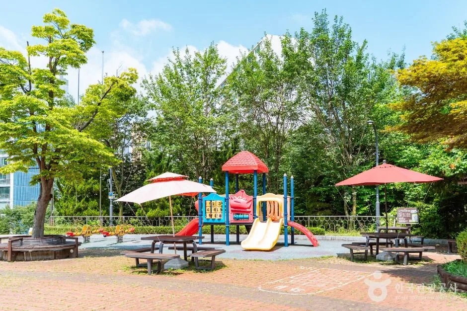
A wooded urban hill park with play spaces, pavilions and paths that connect into longer Dodeoksan walks; choose the entrance and route before checking rain, heat and trail conditions. This catalogue page connects the stop to traveller ratings, current field reports, nearby regional anchors and sourced community corrections.
Each room follows the Seoul calendar day, then becomes a read-only visit record. Share current waits and practical tips without publishing your precise location. Group push notifications stay off during beta.
PLAN THE VISIT
The details that change the day.
Operator facts are labeled separately from Korea Era estimates and guidance.
RegionGwangmyeong · GyeonggiKorean map search광명 도덕산공원Destination splitLower Dodeoksan Park facilities and the Y-shaped suspension bridge require different effort and viewpoints ↗Published waterfall operation09:00-17:30 · winter off · weather and freezing conditions can stop operationBridge dimensionsApproximately 82 m long, 1.5 m wide and 20 m high over the artificial waterfallTrail boundaryStairs, slopes, roots, leaves, mud and ice can change the route; the photo's playground does not represent the ascentParking boundaryThe Dodeoksan neighbourhood lot is limited; the city recommends public transport and lists a longer walk from the civic-gym lotWeather boundaryStrong wind, thunder, heavy rain, freezing weather or maintenance can restrict bridge and waterfall accessPhoto scopeCurrent hero shows a real shaded children's play area surrounded by woodland in lower Dodeoksan Park
It does not show the suspension bridge and does not prove bridge access, waterfall operation, dry trails, light crowds or nearby parking.
Checked August 30, 2026. Recheck current hours, admission, closures and transport before travel.
Map pinAudited official destination coordinate
The place coordinate is exact; use the named gate, parking area or accessible entrance for the final route.
Mobility checkTrail grade, steps, surface conditions, rest points and step-free alternatives are not assumed; check the official access notice.
DAY-OF PLAN
Know the sequence before you go.
Times from the operator are kept separate from Korea Era planning guidance.
01
Choose the lower park or the Y-shaped suspension bridge
The playground, pavilion and lower park are not the same stop as the bridge above the artificial waterfall. Select the entrance, ascent and turnaround before checking heat, rain, wind and daylight.
02
Confirm bridge, waterfall and path controls onsite
The city currently publishes the artificial waterfall at 09:00-17:30 and off in winter, with weather or freezing conditions able to stop it. Bridge and trail safety controls can operate independently.
03
Leave a daylight and footing margin
The 82-metre bridge sits above the lower park and requires a wooded ascent. Wet leaves, stairs, ice and crowding can make the return slower than the outward walk.
Does the current photo show Dodeoksan Suspension Bridge?
No. It shows the genuine lower-park playground. The bridge is reached higher on the wooded route.
Is the artificial waterfall always running?
No. The city lists 09:00-17:30 operation, winter shutdown and weather or freezing-temperature suspensions.
Are the operating details for Dodeoksan Park live?
The displayed guidance was checked August 30, 2026, but it is not a live operator feed. Open the linked official guide and a Korean map again on the day because hours, closures, tickets and transport can change.
Can a traveller correct this page?
Yes. Submit a sourced community wiki correction or a current field report; proposed facts are reviewed before becoming canonical information.
KOREA ERA SHARE
Send this without forcing a sign-up
Public link · Anyone can view
Save this for your Korea tripNo account required during beta.
TRAVELLER CHANNELS
See Dodeoksan Park through a traveler's own post.
Direct links only. Korea Era does not copy the post, imply endorsement or verify live conditions from it.
A wooded urban hill park with play spaces, pavilions and paths that connect into longer Dodeoksan walks; choose the entrance and route before checking rain, heat and trail conditions. This catalogue page connects the stop to traveller ratings, current field reports, nearby regional anchors and sourced community corrections.Recheck the official source before visiting.
Read the full Wiki articleDetailed facts, sources and revision history
KOREA ERA WIKI
TRAVEL KNOWLEDGE DOCUMENT
Dodeoksan Park
도덕산공원A reviewed foundation built from official sources. Traveler edits are checked before publication.
Document statusReviewed foundation4 current facts0 approved edits
Global is the shared verified foundation. Country editions add approved local guidance; ratings, discussions and edit histories stay separate.
Showing the shared Global facts and Global edit history.
A wooded urban hill park with play spaces, pavilions and paths that connect into longer Dodeoksan walks; choose the entrance and route before checking rain, heat and trail conditions. This catalogue page connects the stop to traveller ratings, current field reports, nearby regional anchors and sourced community corrections.
09:00-17:30 · winter off · weather and freezing conditions can stop operation
Bridge dimensions
Approximately 82 m long, 1.5 m wide and 20 m high over the artificial waterfall
Trail boundary
Stairs, slopes, roots, leaves, mud and ice can change the route; the photo's playground does not represent the ascent
Parking boundary
The Dodeoksan neighbourhood lot is limited; the city recommends public transport and lists a longer walk from the civic-gym lot
Weather boundary
Strong wind, thunder, heavy rain, freezing weather or maintenance can restrict bridge and waterfall access
Photo scope
Current hero shows a real shaded children's play area surrounded by woodland in lower Dodeoksan ParkIt does not show the suspension bridge and does not prove bridge access, waterfall operation, dry trails, light crowds or nearby parking.
VISITKOREA · Dodeoksan Park · catalogue checked August 26, 2026Checked 1/1/2026 · Korea Era editors · source
3. Visit flow
01
Before travel
Choose the lower park or the Y-shaped suspension bridge
The playground, pavilion and lower park are not the same stop as the bridge above the artificial waterfall. Select the entrance, ascent and turnaround before checking heat, rain, wind and daylight.
02
At the trail entrance
Confirm bridge, waterfall and path controls onsite
The city currently publishes the artificial waterfall at 09:00-17:30 and off in winter, with weather or freezing conditions able to stop it. Bridge and trail safety controls can operate independently.
03
Before descending
Leave a daylight and footing margin
The 82-metre bridge sits above the lower park and requires a wooded ascent. Wet leaves, stairs, ice and crowding can make the return slower than the outward walk.
4. Traveler tips
Search the suspension bridge specifically if that is the objective; the park pin is useful for the lower facilities and trail approach.
Wear shoes with grip and avoid the exposed bridge during thunder, strong wind or icy conditions.
Use public transport when possible because the nearest city-listed parking is limited.
Search “광명 도덕산공원” in Naver Map or Kakao Map and confirm the exact entrance and return route.
Recheck weather, trail or garden closures, last entry and seasonal conditions before departure.
The audited coordinate identifies the named destination, but the final gate, parking area and step-free entrance still need a live route check.
Does the current photo show Dodeoksan Suspension Bridge?
No. It shows the genuine lower-park playground. The bridge is reached higher on the wooded route.
Is the artificial waterfall always running?
No. The city lists 09:00-17:30 operation, winter shutdown and weather or freezing-temperature suspensions.
Are the operating details for Dodeoksan Park live?
The displayed guidance was checked August 30, 2026, but it is not a live operator feed. Open the linked official guide and a Korean map again on the day because hours, closures, tickets and transport can change.
Can a traveller correct this page?
Yes. Submit a sourced community wiki correction or a current field report; proposed facts are reviewed before becoming canonical information.