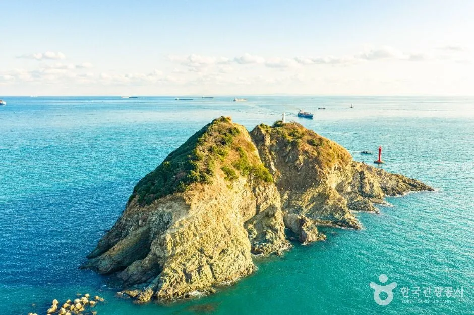
A small rocky offshore island visible from the Amnam and Songdo coast, recognised as part of Busan's coastal geological landscape. The island itself is not a casual walk-on attraction and sea access may be restricted, so use a legal mainland viewpoint or licensed trip, check visibility, waves and tides, and do not climb cliffs, enter protected habitat or rely on an unsupervised boat approach. This catalogue page connects the stop to traveller ratings, current field reports, nearby regional anchors and sourced community corrections.
Help the next traveller understand Dudo Island · Busan.
Visitor insight appears after a real contribution, so empty counters never stand in for activity.
Ask a question or share a current update
Recent traveler reports
Answered by travellers, not checked by us. The verified facts above carry the date we confirmed them.
Loading traveller reports…
Questions about this place
Drafts can be restored in this tab and sign-in session for 24 hours. Saving does not post them; expired copies are not automatically deleted.
Question request recovery is not ready. Recheck your account and saved draft before posting.
TODAY AT THIS PLACE
Ask people visiting Dudo Island · Busan today.
Each room follows the Seoul calendar day, then becomes a read-only visit record. Share current waits and practical tips without publishing your precise location. Group push notifications stay off during beta.
PLAN THE VISIT
Good to know before you visit
Operator facts are labeled separately from Korea Era estimates and guidance.
A reviewed foundation built from official sources. Traveler edits are checked before publication.
RegionSeo-gu · BusanKorean map search부산 서구 두도Official viewpointAmnam Park Dudo Observatory · Amnam-dong san 193-4 ↗Stable geography19,080 m² island about 500 m southwest of the Amnam peninsulaProtected contextDesignated a natural park in 1972; coastal vegetation, seabird nests and an unmanned lighthouse are presentMap scopeThe exact pin is on Dudo itself; route to the named mainland observatory for an ordinary visitAccess boundaryNo casual walk-on or unsupervised landing is promised; follow current park, marine and fishing restrictionsWeather boundaryVisibility, wind, waves, rain and slippery coastal surfaces can remove the safe viewpoint experiencePhoto scopeCurrent hero shows the real twin-peaked rocky islet, small lighthouse and surrounding blue sea
It does not show a public landing, walking route, calm conditions, fishing permission, boat service or accessible viewpoint.
Checked September 1, 2026. Recheck current hours, admission, closures and transport before travel.
Map pinAudited official destination coordinate
The place coordinate is exact; use the named gate, parking area or accessible entrance for the final route.
Mobility checkSlopes, boardwalk gaps, rocks, sand, wind and boarding conditions can change the usable route; confirm before travelling.
DAY-OF PLAN
Know the sequence before you go.
Times from the operator are kept separate from Korea Era planning guidance.
01
Route to the mainland Dudo Observatory
The official visitor guide identifies the viewpoint at Amnam-dong san 193-4. The catalogue island pin confirms what you are looking at, but it is not a walking or landing instruction.
02
Check visibility, wind, waves and barriers
Haze can remove the view and rough coastal conditions can make exposed outlooks unsafe. Stay on the signed mainland route and behind every barrier.
03
Leave the island and wildlife undisturbed
Dudo is a protected rocky habitat with seabird nests and an unmanned lighthouse. Do not improvise a boat, fishing, landing, climbing or drone approach from this page.
No ordinary walking connection is published. Use the mainland Dudo Observatory and treat any marine access as separately controlled.
Does the map pin mark the viewpoint?
No. It identifies the island accurately. The official mainland viewpoint is separately named at Amnam Park, Amnam-dong san 193-4.
Are the operating details for Dudo Island · Busan live?
The displayed guidance was checked September 1, 2026, but it is not a live operator feed. Open the linked official guide and a Korean map again on the day because hours, closures, tickets and transport can change.
Can a traveller correct this page?
Yes. Submit a sourced community wiki correction or a current field report; proposed facts are reviewed before becoming canonical information.
KOREA ERA SHARE
Send this without forcing a sign-up
Public link · Anyone can view
Save this for your Korea tripNo account required during beta.
TRAVELLER CHANNELS
See Dudo Island · Busan through a traveler's own post.
Direct links only. Korea Era does not copy the post, imply endorsement or verify live conditions from it.
A small rocky offshore island visible from the Amnam and Songdo coast, recognised as part of Busan's coastal geological landscape. The island itself is not a casual walk-on attraction and sea access may be restricted, so use a legal mainland viewpoint or licensed trip, check visibility, waves and tides, and do not climb cliffs, enter protected habitat or rely on an unsupervised boat approach. This catalogue page connects the stop to traveller ratings, current field reports, nearby regional anchors and sourced community corrections.Recheck the official source before visiting.
Read the full Wiki articleDetailed facts, sources and revision history
KOREA ERA WIKI
TRAVEL KNOWLEDGE DOCUMENT
Dudo Island · Busan
두도A reviewed foundation built from official sources. Traveler edits are checked before publication.
Document statusReviewed foundation5 current facts0 recent approved edits
Global is the shared verified foundation. Country editions add approved local guidance; ratings, discussions and edit histories stay separate.
Showing the shared Global facts and Global edit history.
A small rocky offshore island visible from the Amnam and Songdo coast, recognised as part of Busan's coastal geological landscape. The island itself is not a casual walk-on attraction and sea access may be restricted, so use a legal mainland viewpoint or licensed trip, check visibility, waves and tides, and do not climb cliffs, enter protected habitat or rely on an unsupervised boat approach. This catalogue page connects the stop to traveller ratings, current field reports, nearby regional anchors and sourced community corrections.
19,080 m² island about 500 m southwest of the Amnam peninsula
Protected context
Designated a natural park in 1972; coastal vegetation, seabird nests and an unmanned lighthouse are present
Map scope
The exact pin is on Dudo itself; route to the named mainland observatory for an ordinary visit
Access boundary
No casual walk-on or unsupervised landing is promised; follow current park, marine and fishing restrictions
Weather boundary
Visibility, wind, waves, rain and slippery coastal surfaces can remove the safe viewpoint experience
Photo scope
Current hero shows the real twin-peaked rocky islet, small lighthouse and surrounding blue seaIt does not show a public landing, walking route, calm conditions, fishing permission, boat service or accessible viewpoint.
Audited official destination coordinateThe place coordinate is exact; use the named gate, parking area or accessible entrance for the final route.
Mobility check
Slopes, boardwalk gaps, rocks, sand, wind and boarding conditions can change the usable route; confirm before travelling.
3. Visit flow
01
Before going to Amnam Park
Route to the mainland Dudo Observatory
The official visitor guide identifies the viewpoint at Amnam-dong san 193-4. The catalogue island pin confirms what you are looking at, but it is not a walking or landing instruction.
02
At the coast
Check visibility, wind, waves and barriers
Haze can remove the view and rough coastal conditions can make exposed outlooks unsafe. Stay on the signed mainland route and behind every barrier.
03
After viewing
Leave the island and wildlife undisturbed
Dudo is a protected rocky habitat with seabird nests and an unmanned lighthouse. Do not improvise a boat, fishing, landing, climbing or drone approach from this page.
4. Traveler tips
Search 암남공원 두도전망대 for the visitor route rather than navigating to the offshore coordinate.
Use a clear, low-wind daylight visit and carry binoculars instead of trying to move closer to wildlife.
Keep drones, speakers and food away from nesting birds and obey every seasonal habitat notice.
Search “부산 서구 두도” in Naver Map or Kakao Map and confirm the exact entrance and return route.
Check rain, wind, waves and any access or transport notice on the day.
The audited coordinate identifies the named destination, but the final gate, parking area and step-free entrance still need a live route check.
No ordinary walking connection is published. Use the mainland Dudo Observatory and treat any marine access as separately controlled.
Does the map pin mark the viewpoint?
No. It identifies the island accurately. The official mainland viewpoint is separately named at Amnam Park, Amnam-dong san 193-4.
Are the operating details for Dudo Island · Busan live?
The displayed guidance was checked September 1, 2026, but it is not a live operator feed. Open the linked official guide and a Korean map again on the day because hours, closures, tickets and transport can change.
Can a traveller correct this page?
Yes. Submit a sourced community wiki correction or a current field report; proposed facts are reviewed before becoming canonical information.