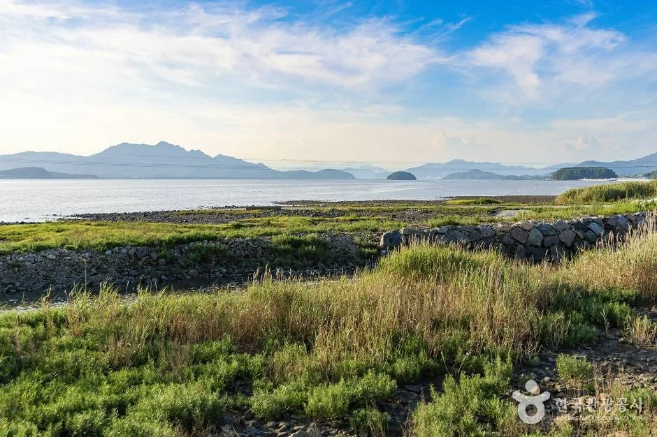
A large tidal bay and protected wetland landscape supporting reed beds, shellfish and migratory birds. This coordinate is one published shore anchor rather than the whole bay or the ecology-park entrance, so choose a named access and recheck tide, heat, wind and boardwalk condition. This catalogue page connects the stop to traveller ratings, current field reports, nearby regional anchors and sourced community corrections.
Visitor insight appears after a real contribution, so empty counters never stand in for activity.
Ask a question or share a current update
Recent traveler reports
Answered by travellers, not checked by us. The verified facts above carry the date we confirmed them.
Loading traveller reports…
Questions about this place
Drafts can be restored in this tab and sign-in session for 24 hours. Saving does not post them; expired copies are not automatically deleted.
Question request recovery is not ready. Recheck your account and saved draft before posting.
TODAY AT THIS PLACE
Ask people visiting Gangjin Bay today.
Each room follows the Seoul calendar day, then becomes a read-only visit record. Share current waits and practical tips without publishing your precise location. Group push notifications stay off during beta.
PLAN THE VISIT
Good to know before you visit
Operator facts are labeled separately from Korea Era estimates and guidance.
A reviewed foundation built from official sources. Traveler edits are checked before publication.
RegionGangjin · JeonnamKorean map search전남광주통합특별시 강진군 신전면 벌정리 강진만 34.5952233820 126.7701508920Current accessContinuously accessible · open year-round ↗Regular closureNone listed for the bay landscape
Tide, weather, boardwalk maintenance and habitat protection can still restrict a segment.
Exact published pointBeoljeong-ri, Sinjeon-myeon, Gangjin · 34.5952233820, 126.7701508920
No street number or universal bay entrance is published.
Ecology-park boundaryGangjin Bay and Gangjin Bay Ecological Park are not one interchangeable pin
Choose the exact park entrance if its reed boardwalk and facilities are the objective.
Wildlife boundaryObserve birds and mudflat habitat without approach, feeding or disturbance
Species presence and visibility are never guaranteed.
Photo scopeReal reed beds, dark tidal flats, open bay water and low offshore islands
The frame does not contain a boardwalk and does not prove today's tide, birds, path access, weather or parking.
Checked September 8, 2026. Recheck current hours, admission, closures and transport before travel.
Map pinAudited official destination coordinate
The place coordinate is exact; use the named gate, parking area or accessible entrance for the final route.
Mobility checkTrail grade, steps, surface conditions, rest points and step-free alternatives are not assumed; check the official access notice.
DAY-OF PLAN
Know the sequence before you go.
Times from the operator are kept separate from Korea Era planning guidance.
01
Choose one named shore access
Gangjin Bay is a broad tidal system. The published coordinate near Beoljeong-ri is one official bay anchor, not the ecology-park gate, every reed path or the full coastal road.
02
Observe from a public route
Mudflat extent, birds, reeds and water level change by tide and season. Stay on open decks and roads rather than entering habitat or soft sediment.
03
Check distance and return
The eastern coastal route and Maryang Port are separate stops. Heat, wind, traffic and sparse transport can make a broad bay drive longer than the map suggests.
Does this pin take me to the ecological-park entrance?
Not necessarily. It is the current official coordinate for the broad Gangjin Bay record; the ecology park should be routed as its own named destination.
Will I see the boardwalk shown in the description at this exact point?
No boardwalk is visible in the published photograph, and the bay spans several access points. Choose the ecology-park entrance for its signed deck route.
Are the operating details for Gangjin Bay live?
The displayed guidance was checked September 8, 2026, but it is not a live operator feed. Open the linked official guide and a Korean map again on the day because hours, closures, tickets and transport can change.
Can a traveller correct this page?
Yes. Submit a sourced community wiki correction or a current field report; proposed facts are reviewed before becoming canonical information.
KOREA ERA SHARE
Send this without forcing a sign-up
Public link · Anyone can view
Save this for your Korea tripNo account required during beta.
TRAVELLER CHANNELS
See Gangjin Bay through a traveler's own post.
Direct links only. Korea Era does not copy the post, imply endorsement or verify live conditions from it.
A large tidal bay and protected wetland landscape supporting reed beds, shellfish and migratory birds. This coordinate is one published shore anchor rather than the whole bay or the ecology-park entrance, so choose a named access and recheck tide, heat, wind and boardwalk condition. This catalogue page connects the stop to traveller ratings, current field reports, nearby regional anchors and sourced community corrections.Recheck the official source before visiting.
Read the full Wiki articleDetailed facts, sources and revision history
KOREA ERA WIKI
TRAVEL KNOWLEDGE DOCUMENT
Gangjin Bay
강진만A reviewed foundation built from official sources. Traveler edits are checked before publication.
Document statusReviewed foundation6 current facts0 recent approved edits
Global is the shared verified foundation. Country editions add approved local guidance; ratings, discussions and edit histories stay separate.
Showing the shared Global facts and Global edit history.
A large tidal bay and protected wetland landscape supporting reed beds, shellfish and migratory birds. This coordinate is one published shore anchor rather than the whole bay or the ecology-park entrance, so choose a named access and recheck tide, heat, wind and boardwalk condition. This catalogue page connects the stop to traveller ratings, current field reports, nearby regional anchors and sourced community corrections.
None listed for the bay landscapeTide, weather, boardwalk maintenance and habitat protection can still restrict a segment.
Exact published point
Beoljeong-ri, Sinjeon-myeon, Gangjin · 34.5952233820, 126.7701508920No street number or universal bay entrance is published.
Ecology-park boundary
Gangjin Bay and Gangjin Bay Ecological Park are not one interchangeable pinChoose the exact park entrance if its reed boardwalk and facilities are the objective.
Wildlife boundary
Observe birds and mudflat habitat without approach, feeding or disturbanceSpecies presence and visibility are never guaranteed.
Photo scope
Real reed beds, dark tidal flats, open bay water and low offshore islandsThe frame does not contain a boardwalk and does not prove today's tide, birds, path access, weather or parking.
Current official guide
VISITKOREA · Gangjin BayChecked September 8, 2026. Recheck current hours, admission, closures and transport before travel.
Map pin
Audited official destination coordinateThe place coordinate is exact; use the named gate, parking area or accessible entrance for the final route.
Mobility check
Trail grade, steps, surface conditions, rest points and step-free alternatives are not assumed; check the official access notice.
3. Visit flow
01
Before navigation
Choose one named shore access
Gangjin Bay is a broad tidal system. The published coordinate near Beoljeong-ri is one official bay anchor, not the ecology-park gate, every reed path or the full coastal road.
02
In daylight and suitable tide
Observe from a public route
Mudflat extent, birds, reeds and water level change by tide and season. Stay on open decks and roads rather than entering habitat or soft sediment.
03
Before extending toward Maryang
Check distance and return
The eastern coastal route and Maryang Port are separate stops. Heat, wind, traffic and sparse transport can make a broad bay drive longer than the map suggests.
4. Traveler tips
Use a tide table and a named public entrance rather than treating the broad bay coordinate as a walkable shoreline everywhere.
Bring binoculars and keep distance from birds; never leave the public path to improve a wildlife photograph.
Save the return route before a sunset visit because rural roads and public transport can become difficult after dark.
Search “전남광주통합특별시 강진군 신전면 벌정리 강진만 34.5952233820 126.7701508920” in Naver Map or Kakao Map and confirm the exact entrance and return route.
Recheck weather, trail or garden closures, last entry and seasonal conditions before departure.
The audited coordinate identifies the named destination, but the final gate, parking area and step-free entrance still need a live route check.
Does this pin take me to the ecological-park entrance?
Not necessarily. It is the current official coordinate for the broad Gangjin Bay record; the ecology park should be routed as its own named destination.
Will I see the boardwalk shown in the description at this exact point?
No boardwalk is visible in the published photograph, and the bay spans several access points. Choose the ecology-park entrance for its signed deck route.
Are the operating details for Gangjin Bay live?
The displayed guidance was checked September 8, 2026, but it is not a live operator feed. Open the linked official guide and a Korean map again on the day because hours, closures, tickets and transport can change.
Can a traveller correct this page?
Yes. Submit a sourced community wiki correction or a current field report; proposed facts are reviewed before becoming canonical information.