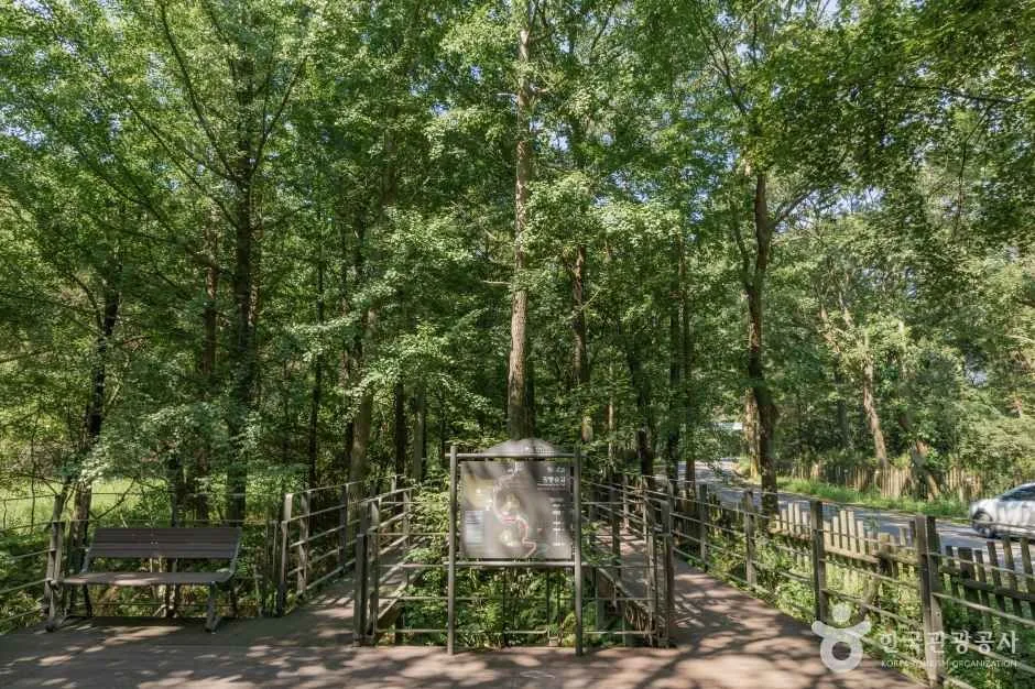
A shaded boardwalk through the protected woodland near Gwangneung; choose the exact entrance and confirm seasonal closures before setting out. This catalogue page connects the stop to traveller ratings, current field reports, nearby regional anchors and sourced community corrections.
Ask people visiting Gwangneung Forest Trail today.
Each room follows the Seoul calendar day, then becomes a read-only visit record. Share current waits and practical tips without publishing your precise location. Group push notifications stay off during beta.
PLAN THE VISIT
The details that change the day.
Operator facts are labeled separately from Korea Era estimates and guidance.
RegionNamyangju · GyeonggiKorean map search광릉숲길 경기도 남양주시 진접읍 봉선사길 193-13Published routeAbout 3 km · Bongseonsa entrance to National Arboretum gate
A one-way walk requires a planned return; the catalogue pin is only one route anchor.
Checked September 8, 2026. Recheck current hours, admission, closures and transport before travel.
Map pinAudited official destination coordinate
The place coordinate is exact; use the named gate, parking area or accessible entrance for the final route.
Mobility checkTrail grade, steps, surface conditions, rest points and step-free alternatives are not assumed; check the official access notice.
DAY-OF PLAN
Know the sequence before you go.
Times from the operator are kept separate from Korea Era planning guidance.
01
Choose the correct end of the 3 km trail
The route runs between Bongseonsa entrance and the Korea National Arboretum gate. Decide whether the walk is one-way or return before selecting transport and parking.
02
Check the arboretum and royal tomb separately
The forest trail is not an admission contract for the National Arboretum, Bongseonsa or Gwangneung Royal Tomb. Each destination keeps independent reservations, closures and final entry.
03
Use weather and daylight as the practical clock
The tourism record does not publish a standalone trail timetable. Check forest restrictions, surface condition and the return connection before setting out.
Is the forest trail inside the National Arboretum ticket?
Do not assume so. The trail links the Bongseonsa side and arboretum gate, while the arboretum has separate admission rules.
Is the catalogue pin the only entrance?
No. The published route is linear and has different end points. Choose the exact start and return plan.
Are the full 3 km step-free?
The audited source does not guarantee that. Confirm the current accessible section, surfaces and return distance before travel.
Are the operating details for Gwangneung Forest Trail live?
The displayed guidance was checked September 8, 2026, but it is not a live operator feed. Open the linked official guide and a Korean map again on the day because hours, closures, tickets and transport can change.
Can a traveller correct this page?
Yes. Submit a sourced community wiki correction or a current field report; proposed facts are reviewed before becoming canonical information.
KOREA ERA SHARE
Send this without forcing a sign-up
Public link · Anyone can view
Save this for your Korea tripNo account required during beta.
TRAVELLER CHANNELS
See Gwangneung Forest Trail through a traveler's own post.
Direct links only. Korea Era does not copy the post, imply endorsement or verify live conditions from it.
A shaded boardwalk through the protected woodland near Gwangneung; choose the exact entrance and confirm seasonal closures before setting out. This catalogue page connects the stop to traveller ratings, current field reports, nearby regional anchors and sourced community corrections.Recheck the official source before visiting.
Read the full Wiki articleDetailed facts, sources and revision history
KOREA ERA WIKI
TRAVEL KNOWLEDGE DOCUMENT
Gwangneung Forest Trail
광릉숲길A reviewed foundation built from official sources. Traveler edits are checked before publication.
Document statusReviewed foundation4 current facts0 approved edits
Global is the shared verified foundation. Country editions add approved local guidance; ratings, discussions and edit histories stay separate.
Showing the shared Global facts and Global edit history.
A shaded boardwalk through the protected woodland near Gwangneung; choose the exact entrance and confirm seasonal closures before setting out. This catalogue page connects the stop to traveller ratings, current field reports, nearby regional anchors and sourced community corrections.
2. Key facts and visitor information
Region
Namyangju · Gyeonggi
Korean map search
광릉숲길 경기도 남양주시 진접읍 봉선사길 193-13
Published route
About 3 km · Bongseonsa entrance to National Arboretum gateA one-way walk requires a planned return; the catalogue pin is only one route anchor.
Correct starting anchor
193-13 Bongseonsa-gil, Jinjeop-eup, NamyangjuThe source describes the broader route as continuing from Bongseonsa entrance to the arboretum.
Ten themed sections
Woodland observation and rest routeSeasonal controls or maintenance can close a section.
Operating boundary
No standalone hours published in the audited tourism recordUse current forest, arboretum and local-government notices rather than inventing an opening time.
Mobility decision
Boardwalk, path surfaces and the return distance varyConfirm the current step-free extent and rest-point spacing for the intended section.
Photo scope
The reviewed hero shows a real shaded forest path, fencing, bench and route signsIt does not prove the condition of all 3 km, a step-free through-route, arboretum admission, dry surfaces or current forest opening.
Audited official destination coordinateThe place coordinate is exact; use the named gate, parking area or accessible entrance for the final route.
Mobility check
Trail grade, steps, surface conditions, rest points and step-free alternatives are not assumed; check the official access notice.
Approved current facts
Transit
Korean map search · 광릉숲길 경기도 남양주시 진접읍 봉선사길 193-13Checked 1/1/2026 · Korea Era editors · source
Official links
VISITKOREA · Gwangneung Forest Trail · catalogue checked August 26, 2026Checked 1/1/2026 · Korea Era editors · source
3. Visit flow
01
Before Namyangju
Choose the correct end of the 3 km trail
The route runs between Bongseonsa entrance and the Korea National Arboretum gate. Decide whether the walk is one-way or return before selecting transport and parking.
02
Before combining stops
Check the arboretum and royal tomb separately
The forest trail is not an admission contract for the National Arboretum, Bongseonsa or Gwangneung Royal Tomb. Each destination keeps independent reservations, closures and final entry.
03
On the trail
Use weather and daylight as the practical clock
The tourism record does not publish a standalone trail timetable. Check forest restrictions, surface condition and the return connection before setting out.
4. Traveler tips
Save both 광릉숲길 and the intended start or finish; a single centre pin cannot plan the return.
Reserve the National Arboretum separately if it is part of the day, and protect its final-entry time.
After rain, verify surfaces and wear shoes suitable for damp woodland rather than assuming continuous dry decking.
Search “광릉숲길 경기도 남양주시 진접읍 봉선사길 193-13” in Naver Map or Kakao Map and confirm the exact entrance and return route.
Recheck weather, trail or garden closures, last entry and seasonal conditions before departure.
The audited coordinate identifies the named destination, but the final gate, parking area and step-free entrance still need a live route check.
Is the forest trail inside the National Arboretum ticket?
Do not assume so. The trail links the Bongseonsa side and arboretum gate, while the arboretum has separate admission rules.
Is the catalogue pin the only entrance?
No. The published route is linear and has different end points. Choose the exact start and return plan.
Are the full 3 km step-free?
The audited source does not guarantee that. Confirm the current accessible section, surfaces and return distance before travel.
Are the operating details for Gwangneung Forest Trail live?
The displayed guidance was checked September 8, 2026, but it is not a live operator feed. Open the linked official guide and a Korean map again on the day because hours, closures, tickets and transport can change.
Can a traveller correct this page?
Yes. Submit a sourced community wiki correction or a current field report; proposed facts are reviewed before becoming canonical information.