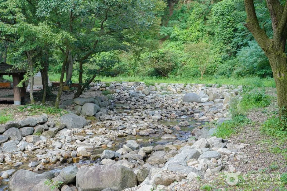
A shaded mountain stream below Byeongpungsan with rocky pools and forest picnic areas; its published daytime span does not make the water inherently safe, so check rain, swimming controls, slippery surfaces, parking and daylight. This catalogue page connects the stop to traveller ratings, current field reports, nearby regional anchors and sourced community corrections.
Each room follows the Seoul calendar day, then becomes a read-only visit record. Share current waits and practical tips without publishing your precise location. Group push notifications stay off during beta.
PLAN THE VISIT
The details that change the day.
Operator facts are labeled separately from Korea Era estimates and guidance.
RegionDamyang · JeonnamKorean map search담양 한재골 계곡Current visitor span09:00-18:00 · no regular closed day listed ↗Water boundaryNo depth, flow, water-quality or swimming-safety guarantee is published for the travel dateRain boundaryUpstream rainfall can change current and access even when the immediate sky looks clearSurface boundaryWet rock, algae, roots and loose stream gravel are slip hazardsParking boundaryParking is listed but summer capacity, traffic control and legal roadside space are not guaranteedNature boundaryExpect insects, limited lighting and changing shade; take all litter and food awayPhoto scopeCurrent hero shows the real rocky stream bed, forest shade and shallow clear pools at Hanjaegol
It does not prove today's water depth, swimming permission, safe current, dry rocks, parking space or open picnic area.
Checked August 30, 2026. Recheck current hours, admission, closures and transport before travel.
Map pinAudited official destination coordinate
The place coordinate is exact; use the named gate, parking area or accessible entrance for the final route.
Mobility checkTrail grade, steps, surface conditions, rest points and step-free alternatives are not assumed; check the official access notice.
DAY-OF PLAN
Know the sequence before you go.
Times from the operator are kept separate from Korea Era planning guidance.
01
Check rain, water controls and the published daytime span
The current record lists 09:00-18:00 and no regular closed day. Heavy rain upstream, drought, clean-up work, fire risk or seasonal safety controls can still make the stream or approach unsuitable.
02
Choose a stable public rest area away from fast water
Clear water is not proof of safe depth or current. Use signed access, supervise children continuously, keep off wet rocks and never enter a closed or flood-prone channel.
03
Pack out rubbish and leave with daylight
Forest shade makes the valley dark before open roads. Dry footwear, remove all food and litter and return before the published end rather than beginning a water stop near closing.
Is swimming guaranteed because the valley is open?
No. General daytime access is not a swimming-safety decision. Follow the live sign and water condition.
Can rain elsewhere affect the stream?
Yes. Upstream rainfall can raise flow rapidly even when conditions at the parking area appear calm.
Are the operating details for Hanjaegol Valley live?
The displayed guidance was checked August 30, 2026, but it is not a live operator feed. Open the linked official guide and a Korean map again on the day because hours, closures, tickets and transport can change.
Can a traveller correct this page?
Yes. Submit a sourced community wiki correction or a current field report; proposed facts are reviewed before becoming canonical information.
KOREA ERA SHARE
Send this without forcing a sign-up
Public link · Anyone can view
Save this for your Korea tripNo account required during beta.
TRAVELLER CHANNELS
See Hanjaegol Valley through a traveler's own post.
Direct links only. Korea Era does not copy the post, imply endorsement or verify live conditions from it.
A shaded mountain stream below Byeongpungsan with rocky pools and forest picnic areas; its published daytime span does not make the water inherently safe, so check rain, swimming controls, slippery surfaces, parking and daylight. This catalogue page connects the stop to traveller ratings, current field reports, nearby regional anchors and sourced community corrections.Recheck the official source before visiting.
Read the full Wiki articleDetailed facts, sources and revision history
KOREA ERA WIKI
TRAVEL KNOWLEDGE DOCUMENT
Hanjaegol Valley
한재골 계곡A reviewed foundation built from official sources. Traveler edits are checked before publication.
Document statusReviewed foundation4 current facts0 approved edits
Global is the shared verified foundation. Country editions add approved local guidance; ratings, discussions and edit histories stay separate.
Showing the shared Global facts and Global edit history.
A shaded mountain stream below Byeongpungsan with rocky pools and forest picnic areas; its published daytime span does not make the water inherently safe, so check rain, swimming controls, slippery surfaces, parking and daylight. This catalogue page connects the stop to traveller ratings, current field reports, nearby regional anchors and sourced community corrections.
No depth, flow, water-quality or swimming-safety guarantee is published for the travel date
Rain boundary
Upstream rainfall can change current and access even when the immediate sky looks clear
Surface boundary
Wet rock, algae, roots and loose stream gravel are slip hazards
Parking boundary
Parking is listed but summer capacity, traffic control and legal roadside space are not guaranteed
Nature boundary
Expect insects, limited lighting and changing shade; take all litter and food away
Photo scope
Current hero shows the real rocky stream bed, forest shade and shallow clear pools at HanjaegolIt does not prove today's water depth, swimming permission, safe current, dry rocks, parking space or open picnic area.
VISITKOREA · Hanjaegol Valley · catalogue checked August 26, 2026Checked 1/1/2026 · Korea Era editors · source
3. Visit flow
01
Before travel
Check rain, water controls and the published daytime span
The current record lists 09:00-18:00 and no regular closed day. Heavy rain upstream, drought, clean-up work, fire risk or seasonal safety controls can still make the stream or approach unsuitable.
02
At the valley
Choose a stable public rest area away from fast water
Clear water is not proof of safe depth or current. Use signed access, supervise children continuously, keep off wet rocks and never enter a closed or flood-prone channel.
03
Before 18:00
Pack out rubbish and leave with daylight
Forest shade makes the valley dark before open roads. Dry footwear, remove all food and litter and return before the published end rather than beginning a water stop near closing.
4. Traveler tips
Check upstream rainfall and local safety notices, not only the weather at your accommodation.
Bring grippy closed footwear and a dry bag; never rely on flip-flops for wet stone.
Arrive outside the summer peak and leave before forest light fades.
Search “담양 한재골 계곡” in Naver Map or Kakao Map and confirm the exact entrance and return route.
Recheck weather, trail or garden closures, last entry and seasonal conditions before departure.
The audited coordinate identifies the named destination, but the final gate, parking area and step-free entrance still need a live route check.
Is swimming guaranteed because the valley is open?
No. General daytime access is not a swimming-safety decision. Follow the live sign and water condition.
Can rain elsewhere affect the stream?
Yes. Upstream rainfall can raise flow rapidly even when conditions at the parking area appear calm.
Are the operating details for Hanjaegol Valley live?
The displayed guidance was checked August 30, 2026, but it is not a live operator feed. Open the linked official guide and a Korean map again on the day because hours, closures, tickets and transport can change.
Can a traveller correct this page?
Yes. Submit a sourced community wiki correction or a current field report; proposed facts are reviewed before becoming canonical information.