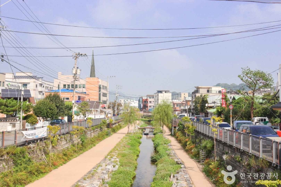
A restored ecological stream and walking corridor crossing central Gongju between Geumhak-dong and the Geumgang, with waterside greenery, rest spaces and small neighbourhood streets connecting the city's history and daily life; the route is listed always open with parking, but choose an exact entry point and check rain, heat, lighting and the walking distance before using it as a link between attractions. This catalogue page connects the stop to traveller ratings, current field reports, nearby regional anchors and sourced community corrections.
Each room follows the Seoul calendar day, then becomes a read-only visit record. Share current waits and practical tips without publishing your precise location. Group push notifications stay off during beta.
PLAN THE VISIT
The details that change the day.
Operator facts are labeled separately from Korea Era estimates and guidance.
Checked August 29, 2026. Recheck current hours, admission, closures and transport before travel.
Map pinApproximate catalogue centre
Use a Korean map app for the exact entrance and final walking route.
Mobility checkTrail grade, steps, surface conditions, rest points and step-free alternatives are not assumed; check the official access notice.
DAY-OF PLAN
Know the sequence before you go.
Times from the operator are kept separate from Korea Era planning guidance.
01
Choose one exact entry and exit
Jemincheon crosses central Gongju rather than operating as one gated attraction. Save a named bridge, street or nearby venue at both ends before using it as a connector.
02
Match the route to visibility
The city installed night-landscape lighting around central bridges, but lighting, events and maintenance can change. Daylight remains the safer default for an unfamiliar longer walk.
03
Recheck the low path and stream level
Do not use a dry-day photograph or an always-open listing as proof that every waterside segment is usable. Follow barriers and move to street level when necessary.
There is no single main gate. It is a long urban stream corridor, so choose a named bridge, street or nearby venue as the exact entry and exit.
Does an always-open map label mean every low path is safe after rain?
No. Water level, mud, maintenance and barriers govern individual segments. Use the street-level route when the low path is restricted.
Are the operating details for Jemincheon Stream live?
The displayed guidance was checked August 29, 2026, but it is not a live operator feed. Open the linked official guide and a Korean map again on the day because hours, closures, tickets and transport can change.
Can a traveller correct this page?
Yes. Submit a sourced community wiki correction or a current field report; proposed facts are reviewed before becoming canonical information.
KOREA ERA SHARE
Send this without forcing a sign-up
Public link · Anyone can view
Save this for your Korea tripNo account required during beta.
TRAVELLER CHANNELS
See Jemincheon Stream through a traveler's own post.
Direct links only. Korea Era does not copy the post, imply endorsement or verify live conditions from it.
A restored ecological stream and walking corridor crossing central Gongju between Geumhak-dong and the Geumgang, with waterside greenery, rest spaces and small neighbourhood streets connecting the city's history and daily life; the route is listed always open with parking, but choose an exact entry point and check rain, heat, lighting and the walking distance before using it as a link between attractions. This catalogue page connects the stop to traveller ratings, current field reports, nearby regional anchors and sourced community corrections.Recheck the official source before visiting.
Read the full Wiki articleDetailed facts, sources and revision history
KOREA ERA WIKI
TRAVEL KNOWLEDGE DOCUMENT
Jemincheon Stream
제민천A reviewed foundation built from official sources. Traveler edits are checked before publication.
Document statusReviewed foundation5 current facts0 approved edits
Global is the shared verified foundation. Country editions add approved local guidance; ratings, discussions and edit histories stay separate.
Showing the shared Global facts and Global edit history.
A restored ecological stream and walking corridor crossing central Gongju between Geumhak-dong and the Geumgang, with waterside greenery, rest spaces and small neighbourhood streets connecting the city's history and daily life; the route is listed always open with parking, but choose an exact entry point and check rain, heat, lighting and the walking distance before using it as a link between attractions. This catalogue page connects the stop to traveller ratings, current field reports, nearby regional anchors and sourced community corrections.
Save a named bridge or nearby venue at both endsThe catalogue centre pin is not a complete walking itinerary.
Night landscape
Central bridge lighting and media glass installedCheck current lighting and event notices rather than expecting one guaranteed nightly show.
Rain boundary
Low paths can become wet, muddy or closedUse street-level alternatives and never cross a barrier.
Neighbourhood etiquette
Residential streets and everyday local routes line the streamKeep voices low at night and do not block doors, bridges or narrow paths for photographs.
Mobility boundary
Path level, ramps, steps and road crossings vary by segmentChoose the exact usable section instead of assuming the full water edge is step-free.
Photo scope
Current hero shows the real restored Jemincheon path passing homes and a church in central GongjuIt does not show live water level, night lighting or accessibility at every entrance.
Open urban stream corridor · no single gate or last-entry time
Lighting, events, construction and water conditions can restrict individual segments.Checked 1/1/2026 · Korea Era editors · source
Official links
Gongju City · Jemincheon night landscape · catalogue checked August 26, 2026Checked 1/1/2026 · Korea Era editors · source
3. Visit flow
01
Before walking
Choose one exact entry and exit
Jemincheon crosses central Gongju rather than operating as one gated attraction. Save a named bridge, street or nearby venue at both ends before using it as a connector.
02
Daylight or the lit evening section
Match the route to visibility
The city installed night-landscape lighting around central bridges, but lighting, events and maintenance can change. Daylight remains the safer default for an unfamiliar longer walk.
03
After rain
Recheck the low path and stream level
Do not use a dry-day photograph or an always-open listing as proof that every waterside segment is usable. Follow barriers and move to street level when necessary.
4. Traveler tips
Use Jemincheon to connect two already chosen old-town stops, not as an undefined walk from one end of the city to the other.
Save a street-level exit before entering a low waterside path so rain or darkness does not force a blind detour.
For night photographs, stay out of the cycle and walking line and avoid aiming into nearby homes.
Search “공주 제민천” in Naver Map or Kakao Map and confirm the exact entrance and return route.
Recheck weather, trail or garden closures, last entry and seasonal conditions before departure.
The catalogue coordinate is an approximate centre pin, not turn-by-turn entrance guidance.
There is no single main gate. It is a long urban stream corridor, so choose a named bridge, street or nearby venue as the exact entry and exit.
Does an always-open map label mean every low path is safe after rain?
No. Water level, mud, maintenance and barriers govern individual segments. Use the street-level route when the low path is restricted.
Are the operating details for Jemincheon Stream live?
The displayed guidance was checked August 29, 2026, but it is not a live operator feed. Open the linked official guide and a Korean map again on the day because hours, closures, tickets and transport can change.
Can a traveller correct this page?
Yes. Submit a sourced community wiki correction or a current field report; proposed facts are reviewed before becoming canonical information.