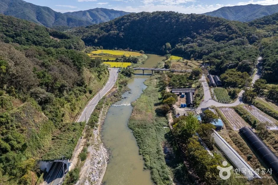
A winding stream valley of low rapids, rural bridges and wooded bends near Chilgapsan; choose a safe access point and check rain, water level, slippery surfaces, road access and daylight. This catalogue page connects the stop to traveller ratings, current field reports, nearby regional anchors and sourced community corrections.
Help the next traveller understand Jicheon Gugok Valley.
Visitor insight appears after a real contribution, so empty counters never stand in for activity.
Ask a question or share a current update
Recent traveler reports
Answered by travellers, not checked by us. The verified facts above carry the date we confirmed them.
Loading traveller reports…
Questions about this place
Drafts can be restored in this tab and sign-in session for 24 hours. Saving does not post them; expired copies are not automatically deleted.
Question request recovery is not ready. Recheck your account and saved draft before posting.
TODAY AT THIS PLACE
Ask people visiting Jicheon Gugok Valley today.
Each room follows the Seoul calendar day, then becomes a read-only visit record. Share current waits and practical tips without publishing your precise location. Group push notifications stay off during beta.
PLAN THE VISIT
Good to know before you visit
Operator facts are labeled separately from Korea Era estimates and guidance.
A reviewed foundation built from official sources. Traveler edits are checked before publication.
RegionCheongyang · ChungnamKorean map search청양 지천구곡Outdoor-access boundaryLong ungated stream valley · no single entrance ↗Water-safety boundaryRainfall · upstream release · depth · current decide access
Do not enter water during or after heavy rain and obey every barrier.
Route choiceSave a named bridge, recreation area or trailhead
The centre coordinate is not a parking guarantee.
Road boundaryNarrow rural roads and working farms line sections of the valley
Use marked parking and keep gates, homes and emergency access clear.
Facility boundaryToilets, changing space and supervision are not continuous
Confirm the exact chosen recreation area before bringing children.
Weather boundarySlippery rock · heat · insects · flash-rise risk
Closed shoes and a daylight exit are safer than sandals on an undefined route.
Photo scopeCurrent hero shows the real winding stream, rural bridges, fields and wooded hills from above
It does not show live depth, water quality, parking or a supervised swimming zone.
Checked August 29, 2026. Recheck current hours, admission, closures and transport before travel.
Map pinApproximate catalogue centre
Use a Korean map app for the exact entrance and final walking route.
Mobility checkTrail grade, steps, surface conditions, rest points and step-free alternatives are not assumed; check the official access notice.
DAY-OF PLAN
Know the sequence before you go.
Times from the operator are kept separate from Korea Era planning guidance.
01
Choose a legal valley access point
Jicheon Gugok is a long stream landscape, not one gated attraction. Select a signed recreation area, bridge or trailhead and confirm parking without blocking a rural road or farm entrance.
02
Check rain upstream and current depth
The county highlights shallow summer recreation around Kkachinae, but depth, current and contamination can change quickly. Never infer safe swimming from a scenic photograph.
03
Leave the low stream edge
Rock, mud and unlit rural roads become harder to read after rain or sunset. Return to the signed road before visibility or weather worsens.
No. The valley has changing depth, current and access conditions. Use only a currently designated area after checking local guidance, weather and supervision.
Does the map pin identify the best parking lot?
No. It is an approximate valley centre. Choose a named access point and verify legal parking before arrival.
Are the operating details for Jicheon Gugok Valley live?
The displayed guidance was checked August 29, 2026, but it is not a live operator feed. Open the linked official guide and a Korean map again on the day because hours, closures, tickets and transport can change.
Can a traveller correct this page?
Yes. Submit a sourced community wiki correction or a current field report; proposed facts are reviewed before becoming canonical information.
KOREA ERA SHARE
Send this without forcing a sign-up
Public link · Anyone can view
Save this for your Korea tripNo account required during beta.
TRAVELLER CHANNELS
See Jicheon Gugok Valley through a traveler's own post.
Direct links only. Korea Era does not copy the post, imply endorsement or verify live conditions from it.
A winding stream valley of low rapids, rural bridges and wooded bends near Chilgapsan; choose a safe access point and check rain, water level, slippery surfaces, road access and daylight. This catalogue page connects the stop to traveller ratings, current field reports, nearby regional anchors and sourced community corrections.Recheck the official source before visiting.
Read the full Wiki articleDetailed facts, sources and revision history
KOREA ERA WIKI
TRAVEL KNOWLEDGE DOCUMENT
Jicheon Gugok Valley
지천구곡A reviewed foundation built from official sources. Traveler edits are checked before publication.
Document statusReviewed foundation5 current facts0 recent approved edits
Global is the shared verified foundation. Country editions add approved local guidance; ratings, discussions and edit histories stay separate.
Showing the shared Global facts and Global edit history.
A winding stream valley of low rapids, rural bridges and wooded bends near Chilgapsan; choose a safe access point and check rain, water level, slippery surfaces, road access and daylight. This catalogue page connects the stop to traveller ratings, current field reports, nearby regional anchors and sourced community corrections.
Rainfall · upstream release · depth · current decide accessDo not enter water during or after heavy rain and obey every barrier.
Route choice
Save a named bridge, recreation area or trailheadThe centre coordinate is not a parking guarantee.
Road boundary
Narrow rural roads and working farms line sections of the valleyUse marked parking and keep gates, homes and emergency access clear.
Facility boundary
Toilets, changing space and supervision are not continuousConfirm the exact chosen recreation area before bringing children.
Weather boundary
Slippery rock · heat · insects · flash-rise riskClosed shoes and a daylight exit are safer than sandals on an undefined route.
Photo scope
Current hero shows the real winding stream, rural bridges, fields and wooded hills from aboveIt does not show live depth, water quality, parking or a supervised swimming zone.
Approximate catalogue centreUse a Korean map app for the exact entrance and final walking route.
Mobility check
Trail grade, steps, surface conditions, rest points and step-free alternatives are not assumed; check the official access notice.
3. Visit flow
01
Before travelling
Choose a legal valley access point
Jicheon Gugok is a long stream landscape, not one gated attraction. Select a signed recreation area, bridge or trailhead and confirm parking without blocking a rural road or farm entrance.
02
Before approaching the water
Check rain upstream and current depth
The county highlights shallow summer recreation around Kkachinae, but depth, current and contamination can change quickly. Never infer safe swimming from a scenic photograph.
03
Before dusk
Leave the low stream edge
Rock, mud and unlit rural roads become harder to read after rain or sunset. Return to the signed road before visibility or weather worsens.
4. Traveler tips
Treat the valley as one selected short segment rather than trying to follow every bend by car or on foot.
Check upstream rain even when the immediate sky is clear and leave the channel immediately if water clouds or rises.
Pack out all food and rubbish; do not enter crops or private riverside plots to reach a photo angle.
Search “청양 지천구곡” in Naver Map or Kakao Map and confirm the exact entrance and return route.
Recheck weather, trail or garden closures, last entry and seasonal conditions before departure.
The catalogue coordinate is an approximate centre pin, not turn-by-turn entrance guidance.
No. The valley has changing depth, current and access conditions. Use only a currently designated area after checking local guidance, weather and supervision.
Does the map pin identify the best parking lot?
No. It is an approximate valley centre. Choose a named access point and verify legal parking before arrival.
Are the operating details for Jicheon Gugok Valley live?
The displayed guidance was checked August 29, 2026, but it is not a live operator feed. Open the linked official guide and a Korean map again on the day because hours, closures, tickets and transport can change.
Can a traveller correct this page?
Yes. Submit a sourced community wiki correction or a current field report; proposed facts are reviewed before becoming canonical information.