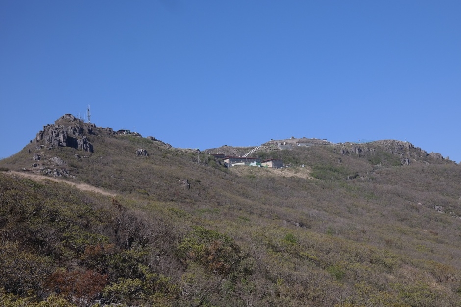
Mudeungsan's protected summit zone combines Cheonwangbong, Jiwangbong and Inwangbong with volcanic columnar terrain; the full military-zone summit route is not an always-open hike and the Korea National Park Service currently operates a separately announced annual opening with reservation, identity and same-day control rules. This catalogue page connects the stop to traveller ratings, current field reports, nearby regional anchors and sourced community corrections.
Help the next traveller understand Mudeungsan Three Peaks.
Visitor insight appears after a real contribution, so empty counters never stand in for activity.
Ask a question or share a current update
Recent traveler reports
Answered by travellers, not checked by us. The verified facts above carry the date we confirmed them.
Loading traveller reports…
Questions about this place
Drafts can be restored in this tab and sign-in session for 24 hours. Saving does not post them; expired copies are not automatically deleted.
Question request recovery is not ready. Recheck your account and saved draft before posting.
TODAY AT THIS PLACE
Ask people visiting Mudeungsan Three Peaks today.
Each room follows the Seoul calendar day, then becomes a read-only visit record. Share current waits and practical tips without publishing your precise location. Group push notifications stay off during beta.
PLAN THE VISIT
Good to know before you visit
Operator facts are labeled separately from Korea Era estimates and guidance.
A reviewed foundation built from official sources. Traveler edits are checked before publication.
Checked August 29, 2026. Recheck current hours, admission, closures and transport before travel.
Map pinApproximate catalogue centre
Use a Korean map app for the exact entrance and final walking route.
Mobility checkTrail grade, steps, surface conditions, rest points and step-free alternatives are not assumed; check the official access notice.
DAY-OF PLAN
Know the sequence before you go.
Times from the operator are kept separate from Korea Era planning guidance.
01
Confirm the announced annual summit opening
KNPS lists the controlled military-zone summit programme as operating once per year. A map pin or ordinary trail opening does not mean the Three Peaks controlled section is available.
02
Use the reserved controlled section
The current guide lists final admission at 3:00 PM, internet reservation plus on-site registration and identity checks. The event notice and same-day control override saved details.
03
Protect the full mountain return
The listed 1.4 km or 1.8 km and one hour describe only the controlled summit segment, not the approach hike from parking, the entire ascent or the return to transport.
Can I hike the Mudeungsan Three Peaks whenever ordinary park trails are open?
No. The full controlled summit zone uses a separately announced opening and reservation system. Ordinary trails or nearby columnar-joint routes do not grant access.
Does the listed one-hour route mean the whole hike takes one hour?
No. It is the controlled summit segment only. Add the approach from the chosen trailhead, ascent, checks, breaks and the complete return to parking or public transport.
Are the operating details for Mudeungsan Three Peaks live?
The displayed guidance was checked August 29, 2026, but it is not a live operator feed. Open the linked official guide and a Korean map again on the day because hours, closures, tickets and transport can change.
Can a traveller correct this page?
Yes. Submit a sourced community wiki correction or a current field report; proposed facts are reviewed before becoming canonical information.
KOREA ERA SHARE
Send this without forcing a sign-up
Public link · Anyone can view
Save this for your Korea tripNo account required during beta.
TRAVELLER CHANNELS
See Mudeungsan Three Peaks through a traveler's own post.
Direct links only. Korea Era does not copy the post, imply endorsement or verify live conditions from it.
Mudeungsan's protected summit zone combines Cheonwangbong, Jiwangbong and Inwangbong with volcanic columnar terrain; the full military-zone summit route is not an always-open hike and the Korea National Park Service currently operates a separately announced annual opening with reservation, identity and same-day control rules. This catalogue page connects the stop to traveller ratings, current field reports, nearby regional anchors and sourced community corrections.Recheck the official source before visiting.
Read the full Wiki articleDetailed facts, sources and revision history
KOREA ERA WIKI
TRAVEL KNOWLEDGE DOCUMENT
Mudeungsan Three Peaks
무등산 정상3봉 (무등산 국가지질공원)A reviewed foundation built from official sources. Traveler edits are checked before publication.
Document statusReviewed foundation5 current facts0 recent approved edits
Global is the shared verified foundation. Country editions add approved local guidance; ratings, discussions and edit histories stay separate.
Showing the shared Global facts and Global edit history.
Mudeungsan's protected summit zone combines Cheonwangbong, Jiwangbong and Inwangbong with volcanic columnar terrain; the full military-zone summit route is not an always-open hike and the Korea National Park Service currently operates a separately announced annual opening with reservation, identity and same-day control rules. This catalogue page connects the stop to traveller ratings, current field reports, nearby regional anchors and sourced community corrections.
9:00 AM–4:00 PM · final admission 3:00 PMThese hours apply only to the announced opening, not ordinary year-round summit access.
Controlled segments
Mokgyo 1.4 km · Jangbuljae 1.8 kmKNPS lists about one hour for each controlled segment; add the substantial approach and full return.
Identity rule
Current guide accepts applications from Korean citizens and requires IDMinors need relationship documents; foreign travellers should not plan access unless KNPS publishes a changed rule.
Group rule
One applicant may register up to ten peopleA group participant list is required and the official reservation record must match the people attending.
Same-day control
Weather and national-park restrictions can cancel accessCarry mountain equipment and obey KNPS and military staff even with a reservation.
Photo scope
Current hero shows the real rocky summit ridge and high Mudeungsan terrainIt does not prove today’s controlled zone is open, show the full approach or guarantee clear weather.
Approximate catalogue centreUse a Korean map app for the exact entrance and final walking route.
Mobility check
Trail grade, steps, surface conditions, rest points and step-free alternatives are not assumed; check the official access notice.
3. Visit flow
01
Before choosing a date
Confirm the announced annual summit opening
KNPS lists the controlled military-zone summit programme as operating once per year. A map pin or ordinary trail opening does not mean the Three Peaks controlled section is available.
02
Opening day · 9:00 AM–4:00 PM
Use the reserved controlled section
The current guide lists final admission at 3:00 PM, internet reservation plus on-site registration and identity checks. The event notice and same-day control override saved details.
03
Before the cutoff
Protect the full mountain return
The listed 1.4 km or 1.8 km and one hour describe only the controlled summit segment, not the approach hike from parking, the entire ascent or the return to transport.
4. Traveler tips
Do not confuse the ordinary Ipseokdae or Seoseokdae hike with entry into the controlled Three Peaks military zone; check both trail control and summit reservation.
Carry the exact accepted ID, reservation details, water, layers, hiking footwear and enough daylight for the approach and return.
Never cross a military or national-park closure for a photograph, even if other hikers appear beyond it or an old route map shows the line.
Search “무등산 정상3봉” in Naver Map or Kakao Map and confirm the exact entrance and return route.
Recheck weather, trail or garden closures, last entry and seasonal conditions before departure.
The catalogue coordinate is an approximate centre pin, not turn-by-turn entrance guidance.
Can I hike the Mudeungsan Three Peaks whenever ordinary park trails are open?
No. The full controlled summit zone uses a separately announced opening and reservation system. Ordinary trails or nearby columnar-joint routes do not grant access.
Does the listed one-hour route mean the whole hike takes one hour?
No. It is the controlled summit segment only. Add the approach from the chosen trailhead, ascent, checks, breaks and the complete return to parking or public transport.
Are the operating details for Mudeungsan Three Peaks live?
The displayed guidance was checked August 29, 2026, but it is not a live operator feed. Open the linked official guide and a Korean map again on the day because hours, closures, tickets and transport can change.
Can a traveller correct this page?
Yes. Submit a sourced community wiki correction or a current field report; proposed facts are reviewed before becoming canonical information.