A ridge fortress overlooking the Han River estuary and northern border landscape; choose an exact trailhead and check visibility, weather and return transport. This catalogue page connects the stop to traveller ratings, current field reports, nearby regional anchors and sourced community corrections.
Help the next traveller understand Munsusanseong Fortress.
Visitor insight appears after a real contribution, so empty counters never stand in for activity.
Ask a question or share a current update
Recent traveler reports
Answered by travellers, not checked by us. The verified facts above carry the date we confirmed them.
Loading traveller reports…
Questions about this place
Drafts can be restored in this tab and sign-in session for 24 hours. Saving does not post them; expired copies are not automatically deleted.
Question request recovery is not ready. Recheck your account and saved draft before posting.
TODAY AT THIS PLACE
Ask people visiting Munsusanseong Fortress today.
Each room follows the Seoul calendar day, then becomes a read-only visit record. Share current waits and practical tips without publishing your precise location. Group push notifications stay off during beta.
PLAN THE VISIT
Good to know before you visit
Operator facts are labeled separately from Korea Era estimates and guidance.
A reviewed foundation built from official sources. Traveler edits are checked before publication.
Checked September 8, 2026. Recheck current hours, admission, closures and transport before travel.
Map pinAudited official destination coordinate
The place coordinate is exact; use the named gate, parking area or accessible entrance for the final route.
Mobility checkConfirm the current step-free entrance, lift availability, rest areas and accessible toilets with the venue.
DAY-OF PLAN
Know the sequence before you go.
Times from the operator are kept separate from Korea Era planning guidance.
01
Choose a named trailhead
The catalogue coordinate identifies the fortress locality, but the surviving wall follows a ridge. Save the current parking area, intended gate or ascent and return route instead of navigating only to the broad heritage name.
02
Follow one bounded wall section
The surviving mountain wall and restored pavilion involve slopes and uneven ground. Set a turnaround time based on weather, visibility and the same-way descent.
03
Separate history from the former shoreline works
The fortress defended the route toward Ganghwa and saw battle during the 1866 French campaign. Much of the former coastal wall and gates no longer survive, so interpret only structures and routes that are present and signed.
No. It marks the published fortress locality. Select the practical entrance for the chosen route.
Does the entire original fortress survive?
No. The tourism record says the coastal wall and gate structures were lost or altered, while ridge sections remain.
Is year-round access a weather guarantee?
No. Rain, ice, heat, poor visibility or preservation work can make a section unsuitable.
Are the operating details for Munsusanseong Fortress live?
The displayed guidance was checked September 8, 2026, but it is not a live operator feed. Open the linked official guide and a Korean map again on the day because hours, closures, tickets and transport can change.
Can a traveller correct this page?
Yes. Submit a sourced community wiki correction or a current field report; proposed facts are reviewed before becoming canonical information.
KOREA ERA SHARE
Send this without forcing a sign-up
Public link · Anyone can view
Save this for your Korea tripNo account required during beta.
TRAVELLER CHANNELS
See Munsusanseong Fortress through a traveler's own post.
Direct links only. Korea Era does not copy the post, imply endorsement or verify live conditions from it.
A ridge fortress overlooking the Han River estuary and northern border landscape; choose an exact trailhead and check visibility, weather and return transport. This catalogue page connects the stop to traveller ratings, current field reports, nearby regional anchors and sourced community corrections.Recheck the official source before visiting.
Read the full Wiki articleDetailed facts, sources and revision history
KOREA ERA WIKI
TRAVEL KNOWLEDGE DOCUMENT
Munsusanseong Fortress
김포 문수산성A reviewed foundation built from official sources. Traveler edits are checked before publication.
Document statusReviewed foundation4 current facts0 recent approved edits
Global is the shared verified foundation. Country editions add approved local guidance; ratings, discussions and edit histories stay separate.
Showing the shared Global facts and Global edit history.
A ridge fortress overlooking the Han River estuary and northern border landscape; choose an exact trailhead and check visibility, weather and return transport. This catalogue page connects the stop to traveller ratings, current field reports, nearby regional anchors and sourced community corrections.
2. Key facts and visitor information
Region
Gimpo · Gyeonggi
Korean map search
김포 문수산성 경기도 김포시 월곶면 성동리 산36-1
Outdoor heritage
Open year-round · continuously accessible baselineWeather, preservation work and trail safety can still close a section.
Fortress history
Stone fortress built in 1694 · repaired in 1812The remaining ridge wall is only part of the historical defensive system.
Published locality
San 36-1, Seongdong-ri, Wolgot-myeon, GimpoConfirm the usable trailhead and parking lot separately before travel.
Surviving fabric
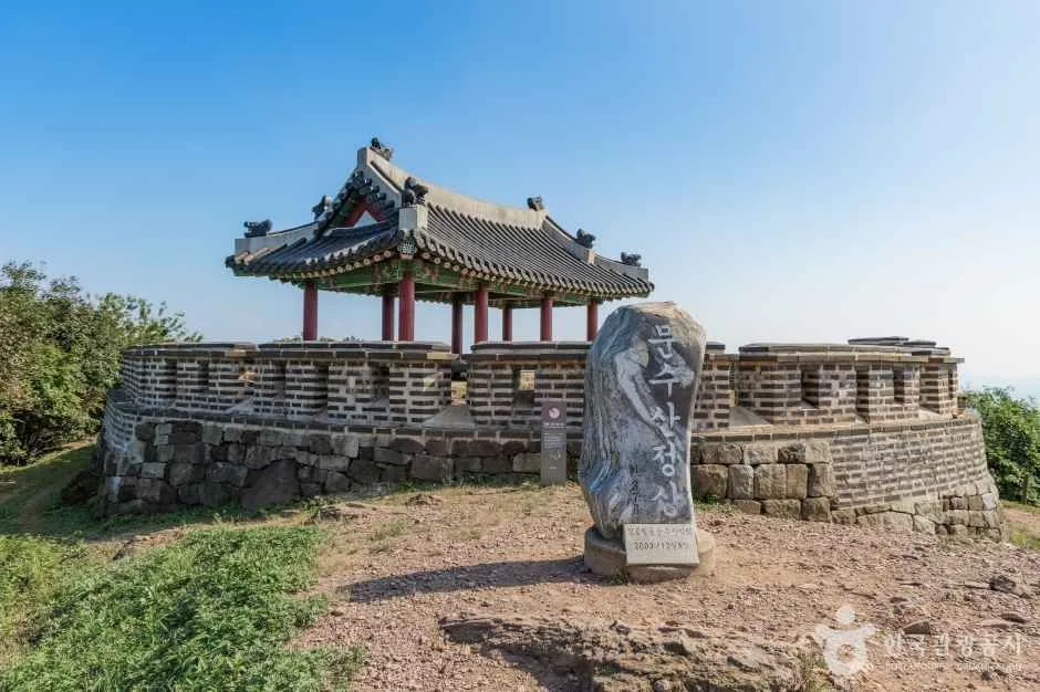
Mountain-ridge walls and restored structuresFormer coastal walls and gate towers were lost or altered after the 1866 fighting.
Parking
AvailableThe source does not identify the best lot for every route or guarantee capacity and step-free access.
Photo scope
The reviewed hero shows the real Munsusanseong marker, stone wall and ridge pavilionIt does not prove the full wall route, today's visibility, trail surface, parking space or access to every structure.
Audited official destination coordinateThe place coordinate is exact; use the named gate, parking area or accessible entrance for the final route.
Mobility check
Confirm the current step-free entrance, lift availability, rest areas and accessible toilets with the venue.
3. Visit flow
01
Before Gimpo
Choose a named trailhead
The catalogue coordinate identifies the fortress locality, but the surviving wall follows a ridge. Save the current parking area, intended gate or ascent and return route instead of navigating only to the broad heritage name.
02
On the ridge
Follow one bounded wall section
The surviving mountain wall and restored pavilion involve slopes and uneven ground. Set a turnaround time based on weather, visibility and the same-way descent.
03
Before leaving
Separate history from the former shoreline works
The fortress defended the route toward Ganghwa and saw battle during the 1866 French campaign. Much of the former coastal wall and gates no longer survive, so interpret only structures and routes that are present and signed.
4. Traveler tips
Pin a named entrance or parking area after choosing the intended wall section.
Bring grip footwear and leave time for the descent; the ridge is not a flat architectural stop.
Use current on-site interpretation for reconstructed and surviving sections instead of inferring the 1694 layout from one view.
Search “김포 문수산성 경기도 김포시 월곶면 성동리 산36-1” in Naver Map or Kakao Map and confirm the exact entrance and return route.
Hours, admission, closures and programme schedules can change; use the official source before departure.
The audited coordinate identifies the named destination, but the final gate, parking area and step-free entrance still need a live route check.
No. It marks the published fortress locality. Select the practical entrance for the chosen route.
Does the entire original fortress survive?
No. The tourism record says the coastal wall and gate structures were lost or altered, while ridge sections remain.
Is year-round access a weather guarantee?
No. Rain, ice, heat, poor visibility or preservation work can make a section unsuitable.
Are the operating details for Munsusanseong Fortress live?
The displayed guidance was checked September 8, 2026, but it is not a live operator feed. Open the linked official guide and a Korean map again on the day because hours, closures, tickets and transport can change.
Can a traveller correct this page?
Yes. Submit a sourced community wiki correction or a current field report; proposed facts are reviewed before becoming canonical information.