A surviving coastal artillery complex on Gadeokdo with brick gun emplacements, tunnels and military remains embedded in a wooded shoreline landscape. The site contains colonial and wartime history as well as uneven, damp and partly open structures, so use the marked route, bring a light, avoid restricted interiors and check rain, road access and daylight before going. This catalogue page connects the stop to traveller ratings, current field reports, nearby regional anchors and sourced community corrections.
Help the next traveller understand Oeyangpo Artillery Position.
Visitor insight appears after a real contribution, so empty counters never stand in for activity.
Ask a question or share a current update
Recent traveler reports
Answered by travellers, not checked by us. The verified facts above carry the date we confirmed them.
Loading traveller reports…
Questions about this place
Drafts can be restored in this tab and sign-in session for 24 hours. Saving does not post them; expired copies are not automatically deleted.
Question request recovery is not ready. Recheck your account and saved draft before posting.
TODAY AT THIS PLACE
Ask people visiting Oeyangpo Artillery Position today.
Each room follows the Seoul calendar day, then becomes a read-only visit record. Share current waits and practical tips without publishing your precise location. Group push notifications stay off during beta.
PLAN THE VISIT
Good to know before you visit
Operator facts are labeled separately from Korea Era estimates and guidance.
A reviewed foundation built from official sources. Traveler edits are checked before publication.
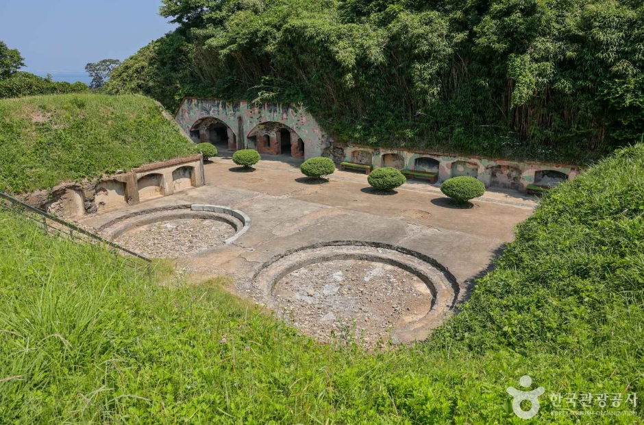
RegionGangseo-gu · BusanKorean map search가덕도 외양포 포진지Heritage safetyUneven, damp and partly open military remains; use only the recognised route ↗Historical boundaryInterpret as a Japanese-colonial coastal artillery site and displaced-village landscape, not a recreation bunkerInterior boundaryNo opening, tunnel or dark room is public merely because it is physically accessibleEquipmentGrip footwear and a small light help with approved shaded sections; never use a light to justify restricted entryTransport realityFix the return vehicle or bus before walking; southern Gadeokdo services are limitedPhoto scopeThe current hero shows the real circular concrete gun positions, low walls and arched brick openings within green earthworks
It does not prove every tunnel is open, show the full village history, identify a safe interior, confirm dry footing or report today's road and construction conditions.
Checked September 1, 2026. Recheck current hours, admission, closures and transport before travel.
Map pinAudited official destination coordinate
The place coordinate is exact; use the named gate, parking area or accessible entrance for the final route.
Mobility checkConfirm the current step-free entrance, lift availability, rest areas and accessible toilets with the venue.
DAY-OF PLAN
Know the sequence before you go.
Times from the operator are kept separate from Korea Era planning guidance.
01
Check the road, weather and daylight return
The artillery position is an exposed, partly unstaffed military-history landscape. Rain, construction, vegetation and road control can change the approach.
02
Follow the marked heritage route
Read the Japanese-colonial military history and distinguish visible gun emplacements from tunnels, village remains and any restricted structure. Do not improvise an interior route.
03
Leave damp structures and the village route early
Brick, concrete, moss, roots, drops and weak interior light create fall hazards. Preserve enough time for the long Gadeokdo return.
No. Use only signed or clearly approved visitor sections. Damp, dark or open-looking structures can still be unsafe or restricted.
Is the site a restored museum?
No. It is a surviving military landscape with dispersed remains and limited interpretation, not one staffed indoor museum.
Is it suitable after rain?
Rain increases moss, mud, brick and concrete hazards. Recheck conditions and choose another stop if the route is wet or controlled.
Can the photo prove the whole route is open?
No. It confirms specific gun positions and openings only; live access and safety require a same-day check.
Are the operating details for Oeyangpo Artillery Position live?
The displayed guidance was checked September 1, 2026, but it is not a live operator feed. Open the linked official guide and a Korean map again on the day because hours, closures, tickets and transport can change.
Can a traveller correct this page?
Yes. Submit a sourced community wiki correction or a current field report; proposed facts are reviewed before becoming canonical information.
KOREA ERA SHARE
Send this without forcing a sign-up
Public link · Anyone can view
Save this for your Korea tripNo account required during beta.
TRAVELLER CHANNELS
See Oeyangpo Artillery Position through a traveler's own post.
Direct links only. Korea Era does not copy the post, imply endorsement or verify live conditions from it.
A surviving coastal artillery complex on Gadeokdo with brick gun emplacements, tunnels and military remains embedded in a wooded shoreline landscape. The site contains colonial and wartime history as well as uneven, damp and partly open structures, so use the marked route, bring a light, avoid restricted interiors and check rain, road access and daylight before going. This catalogue page connects the stop to traveller ratings, current field reports, nearby regional anchors and sourced community corrections.Recheck the official source before visiting.
Read the full Wiki articleDetailed facts, sources and revision history
KOREA ERA WIKI
TRAVEL KNOWLEDGE DOCUMENT
Oeyangpo Artillery Position
외양포 포진지A reviewed foundation built from official sources. Traveler edits are checked before publication.
Document statusReviewed foundation4 current facts0 recent approved edits
Global is the shared verified foundation. Country editions add approved local guidance; ratings, discussions and edit histories stay separate.
Showing the shared Global facts and Global edit history.
A surviving coastal artillery complex on Gadeokdo with brick gun emplacements, tunnels and military remains embedded in a wooded shoreline landscape. The site contains colonial and wartime history as well as uneven, damp and partly open structures, so use the marked route, bring a light, avoid restricted interiors and check rain, road access and daylight before going. This catalogue page connects the stop to traveller ratings, current field reports, nearby regional anchors and sourced community corrections.
Interpret as a Japanese-colonial coastal artillery site and displaced-village landscape, not a recreation bunker
Interior boundary
No opening, tunnel or dark room is public merely because it is physically accessible
Equipment
Grip footwear and a small light help with approved shaded sections; never use a light to justify restricted entry
Transport reality
Fix the return vehicle or bus before walking; southern Gadeokdo services are limited
Photo scope
The current hero shows the real circular concrete gun positions, low walls and arched brick openings within green earthworksIt does not prove every tunnel is open, show the full village history, identify a safe interior, confirm dry footing or report today's road and construction conditions.
Audited official destination coordinateThe place coordinate is exact; use the named gate, parking area or accessible entrance for the final route.
Mobility check
Confirm the current step-free entrance, lift availability, rest areas and accessible toilets with the venue.
3. Visit flow
01
Before Gadeokdo travel
Check the road, weather and daylight return
The artillery position is an exposed, partly unstaffed military-history landscape. Rain, construction, vegetation and road control can change the approach.
02
At the site
Follow the marked heritage route
Read the Japanese-colonial military history and distinguish visible gun emplacements from tunnels, village remains and any restricted structure. Do not improvise an interior route.
03
Before dusk
Leave damp structures and the village route early
Brick, concrete, moss, roots, drops and weak interior light create fall hazards. Preserve enough time for the long Gadeokdo return.
4. Traveler tips
Read the site as difficult colonial and military history; avoid playful posing on gun positions or memorial elements.
Go in dry daylight and keep a coastal fallback if the approach or structures are unsafe.
Do not enter private village property while following heritage remains spread around Oeyangpo.
Search “가덕도 외양포 포진지” in Naver Map or Kakao Map and confirm the exact entrance and return route.
Hours, admission, closures and programme schedules can change; use the official source before departure.
The audited coordinate identifies the named destination, but the final gate, parking area and step-free entrance still need a live route check.
No. Use only signed or clearly approved visitor sections. Damp, dark or open-looking structures can still be unsafe or restricted.
Is the site a restored museum?
No. It is a surviving military landscape with dispersed remains and limited interpretation, not one staffed indoor museum.
Is it suitable after rain?
Rain increases moss, mud, brick and concrete hazards. Recheck conditions and choose another stop if the route is wet or controlled.
Can the photo prove the whole route is open?
No. It confirms specific gun positions and openings only; live access and safety require a same-day check.
Are the operating details for Oeyangpo Artillery Position live?
The displayed guidance was checked September 1, 2026, but it is not a live operator feed. Open the linked official guide and a Korean map again on the day because hours, closures, tickets and transport can change.
Can a traveller correct this page?
Yes. Submit a sourced community wiki correction or a current field report; proposed facts are reviewed before becoming canonical information.