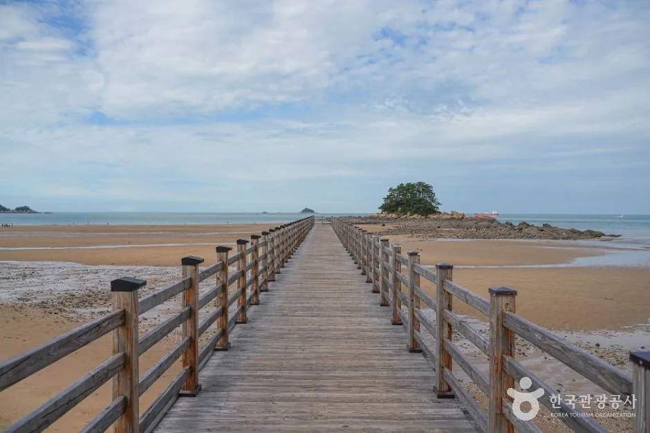
A long first section of Taean's coastal trail linking Hakampo, dune-backed shore and small fishing settlements; choose a realistic segment and verify tide, weather, exposed sections, water, daylight and return transport before walking. This catalogue page connects the stop to traveller ratings, current field reports, nearby regional anchors and sourced community corrections.
Help the next traveller understand Taean Baragil Coastal Trail.
Visitor insight appears after a real contribution, so empty counters never stand in for activity.
Ask a question or share a current update
Recent traveler reports
Answered by travellers, not checked by us. The verified facts above carry the date we confirmed them.
Loading traveller reports…
Questions about this place
Drafts can be restored in this tab and sign-in session for 24 hours. Saving does not post them; expired copies are not automatically deleted.
Question request recovery is not ready. Recheck your account and saved draft before posting.
TODAY AT THIS PLACE
Ask people visiting Taean Baragil Coastal Trail today.
Each room follows the Seoul calendar day, then becomes a read-only visit record. Share current waits and practical tips without publishing your precise location. Group push notifications stay off during beta.
PLAN THE VISIT
Good to know before you visit
Operator facts are labeled separately from Korea Era estimates and guidance.
A reviewed foundation built from official sources. Traveler edits are checked before publication.
Checked August 29, 2026. Recheck current hours, admission, closures and transport before travel.
Map pinApproximate catalogue centre
Use a Korean map app for the exact entrance and final walking route.
Mobility checkSlopes, boardwalk gaps, rocks, sand, wind and boarding conditions can change the usable route; confirm before travelling.
DAY-OF PLAN
Know the sequence before you go.
Times from the operator are kept separate from Korea Era planning guidance.
01
Plan 10.2 km and about four hours
The official course runs from Hakampo Nature Trail through Guryepo and Sinduri dune to Sinduri Beach. This is a point-to-point commitment, not a short boardwalk loop.
02
Confirm trail notices, tide and weather
National-park controls, wind, heat, coastal flooding and restoration can close or redirect sections.
03
Lock the return transfer
The start and finish are different rural locations. Confirm a second vehicle, taxi or usable bus before beginning.
No. The official first course is a 10.2 km point-to-point trail estimated at about four hours.
Can I walk across the dunes as part of the course?
No. Use designated routes; protected dune areas remain off limits.
Are the operating details for Taean Baragil Coastal Trail live?
The displayed guidance was checked August 29, 2026, but it is not a live operator feed. Open the linked official guide and a Korean map again on the day because hours, closures, tickets and transport can change.
Can a traveller correct this page?
Yes. Submit a sourced community wiki correction or a current field report; proposed facts are reviewed before becoming canonical information.
KOREA ERA SHARE
Send this without forcing a sign-up
Public link · Anyone can view
Save this for your Korea tripNo account required during beta.
TRAVELLER CHANNELS
See Taean Baragil Coastal Trail through a traveler's own post.
Direct links only. Korea Era does not copy the post, imply endorsement or verify live conditions from it.
A long first section of Taean's coastal trail linking Hakampo, dune-backed shore and small fishing settlements; choose a realistic segment and verify tide, weather, exposed sections, water, daylight and return transport before walking. This catalogue page connects the stop to traveller ratings, current field reports, nearby regional anchors and sourced community corrections.Recheck the official source before visiting.
Read the full Wiki articleDetailed facts, sources and revision history
KOREA ERA WIKI
TRAVEL KNOWLEDGE DOCUMENT
Taean Baragil Coastal Trail
태안 해변길 1코스 바라길A reviewed foundation built from official sources. Traveler edits are checked before publication.
Document statusReviewed foundation4 current facts0 recent approved edits
Global is the shared verified foundation. Country editions add approved local guidance; ratings, discussions and edit histories stay separate.
Showing the shared Global facts and Global edit history.
A long first section of Taean's coastal trail linking Hakampo, dune-backed shore and small fishing settlements; choose a realistic segment and verify tide, weather, exposed sections, water, daylight and return transport before walking. This catalogue page connects the stop to traveller ratings, current field reports, nearby regional anchors and sourced community corrections.
Hakampo Nature Trail to Sinduri BeachSave both endpoints and do not assume the map pin is a circular trailhead.
Protected-dune boundary
Observe Sinduri from the designated outer routeThe official course description does not authorise crossing protected dunes.
Weather and tide
Check marine forecast, rain, heat and exposed shoreLeave closed or flooded sections and never improvise around a barrier.
Supplies
Carry water, sun protection and offline route dataFood, shade and refill points are not continuous along the coastal course.
Trail contact
Taean Coast National Park - 041-672-7267Confirm current controls and the correct starting support centre.
Photo scope
Current hero shows a real timber walkway across Taean's broad tidal shoreIt is not a live tide, route, surface or closure report for the entire 10.2 km.
Approximate catalogue centreUse a Korean map app for the exact entrance and final walking route.
Mobility check
Slopes, boardwalk gaps, rocks, sand, wind and boarding conditions can change the usable route; confirm before travelling.
3. Visit flow
01
Before the hike
Plan 10.2 km and about four hours
The official course runs from Hakampo Nature Trail through Guryepo and Sinduri dune to Sinduri Beach. This is a point-to-point commitment, not a short boardwalk loop.
02
At the start
Confirm trail notices, tide and weather
National-park controls, wind, heat, coastal flooding and restoration can close or redirect sections.
03
Before walking away
Lock the return transfer
The start and finish are different rural locations. Confirm a second vehicle, taxi or usable bus before beginning.
4. Traveler tips
Start early enough to finish in daylight and add a buffer beyond the official four-hour estimate.
Download the route and both Korean endpoint names before leaving reliable mobile coverage.
Turn back at any closed, flooded or eroded section instead of creating an informal bypass through habitat.
Search “태안 해변길 1코스 바라길” in Naver Map or Kakao Map and confirm the exact entrance and return route.
Check rain, wind, waves and any access or transport notice on the day.
The catalogue coordinate is an approximate centre pin, not turn-by-turn entrance guidance.
No. The official first course is a 10.2 km point-to-point trail estimated at about four hours.
Can I walk across the dunes as part of the course?
No. Use designated routes; protected dune areas remain off limits.
Are the operating details for Taean Baragil Coastal Trail live?
The displayed guidance was checked August 29, 2026, but it is not a live operator feed. Open the linked official guide and a Korean map again on the day because hours, closures, tickets and transport can change.
Can a traveller correct this page?
Yes. Submit a sourced community wiki correction or a current field report; proposed facts are reviewed before becoming canonical information.