A section of Bucheon's cultural walking network linking neighbourhood streets, wooded slopes and local heritage around Wonmi; choose a segment and check the current route, daylight and wet-weather surfaces. This catalogue page connects the stop to traveller ratings, current field reports, nearby regional anchors and sourced community corrections.
Each room follows the Seoul calendar day, then becomes a read-only visit record. Share current waits and practical tips without publishing your precise location. Group push notifications stay off during beta.
PLAN THE VISIT
The details that change the day.
Operator facts are labeled separately from Korea Era estimates and guidance.
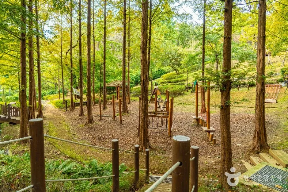
RegionBucheon · GyeonggiKorean map search부천문화둘레길 원미마실길Official route8.4 km · approximately 140 minutes · linear start and finish ↗Official startBucheon Station north-side Maru SquareOfficial finishSoshin bus terminus after the Wonmi market sectionRoute characterCommercial streets, restored stream, neighbourhood lanes, temple edge, forest slope, summit, literary street and marketsAccess boundaryA public walking route does not guarantee a continuous step-free surface, lighting, open temple, library, market or toiletSafety boundaryCheck heat, rain, snow, ice, air quality, daylight and road crossings before the mountain sectionPhoto scopeCurrent hero shows a real shaded Wonmi forest section with exercise stations, timber steps and trees
It does not show the urban start, full route, summit, market finish, current wayfinding, dry footing or step-free access.
Checked August 30, 2026. Recheck current hours, admission, closures and transport before travel.
Map pinAudited official destination coordinate
The place coordinate is exact; use the named gate, parking area or accessible entrance for the final route.
Mobility checkTrail grade, steps, surface conditions, rest points and step-free alternatives are not assumed; check the official access notice.
DAY-OF PLAN
Know the sequence before you go.
Times from the operator are kept separate from Korea Era planning guidance.
01
Plan the full 8.4 km linear route or a named segment
The city lists roughly 140 minutes for the complete route from Bucheon Station Maru Square to the Soshin bus terminus. Add time for navigation, hills, traffic crossings, stops and a separate return.
02
Follow the urban-to-mountain sequence
The route passes Bucheon University Street, Simgokcheon, Seokwangsa, Wonmi Park, the Wonmisan summit, library, literary streets and markets. Save the official map because the surface and wayfinding change between each section.
03
Reassess weather, footing and the finish transport
Stairs, forest slopes, wet leaves, heat and ice can make the mountain section slower than the urban section. Turn around or skip the summit when daylight, weather or mobility no longer supports the complete route.
No. The official route is linear, starting at Bucheon Station Maru Square and finishing near the Soshin bus terminus.
Is the full route step-free?
No such guarantee is published. It includes streets, crossings, slopes, forest paths and the Wonmisan summit, so confirm or shorten the route for mobility needs.
Are the operating details for Wonmi Mashil-gil Trail live?
The displayed guidance was checked August 30, 2026, but it is not a live operator feed. Open the linked official guide and a Korean map again on the day because hours, closures, tickets and transport can change.
Can a traveller correct this page?
Yes. Submit a sourced community wiki correction or a current field report; proposed facts are reviewed before becoming canonical information.
KOREA ERA SHARE
Send this without forcing a sign-up
Public link · Anyone can view
Save this for your Korea tripNo account required during beta.
TRAVELLER CHANNELS
See Wonmi Mashil-gil Trail through a traveler's own post.
Direct links only. Korea Era does not copy the post, imply endorsement or verify live conditions from it.
A section of Bucheon's cultural walking network linking neighbourhood streets, wooded slopes and local heritage around Wonmi; choose a segment and check the current route, daylight and wet-weather surfaces. This catalogue page connects the stop to traveller ratings, current field reports, nearby regional anchors and sourced community corrections.Recheck the official source before visiting.
Read the full Wiki articleDetailed facts, sources and revision history
KOREA ERA WIKI
TRAVEL KNOWLEDGE DOCUMENT
Wonmi Mashil-gil Trail
원미마실길A reviewed foundation built from official sources. Traveler edits are checked before publication.
Document statusReviewed foundation5 current facts0 approved edits
Global is the shared verified foundation. Country editions add approved local guidance; ratings, discussions and edit histories stay separate.
Showing the shared Global facts and Global edit history.
A section of Bucheon's cultural walking network linking neighbourhood streets, wooded slopes and local heritage around Wonmi; choose a segment and check the current route, daylight and wet-weather surfaces. This catalogue page connects the stop to traveller ratings, current field reports, nearby regional anchors and sourced community corrections.
Soshin bus terminus after the Wonmi market section
Route character
Commercial streets, restored stream, neighbourhood lanes, temple edge, forest slope, summit, literary street and markets
Access boundary
A public walking route does not guarantee a continuous step-free surface, lighting, open temple, library, market or toilet
Safety boundary
Check heat, rain, snow, ice, air quality, daylight and road crossings before the mountain section
Photo scope
Current hero shows a real shaded Wonmi forest section with exercise stations, timber steps and treesIt does not show the urban start, full route, summit, market finish, current wayfinding, dry footing or step-free access.
A public walking route does not guarantee a continuous step-free surface, lighting, open temple, library, market or toiletChecked 1/1/2026 · Korea Era editors · source
Official links
VISITKOREA · Wonmi Mashil-gil Trail · catalogue checked August 26, 2026Checked 1/1/2026 · Korea Era editors · source
3. Visit flow
01
Before walking
Plan the full 8.4 km linear route or a named segment
The city lists roughly 140 minutes for the complete route from Bucheon Station Maru Square to the Soshin bus terminus. Add time for navigation, hills, traffic crossings, stops and a separate return.
02
From Bucheon Station
Follow the urban-to-mountain sequence
The route passes Bucheon University Street, Simgokcheon, Seokwangsa, Wonmi Park, the Wonmisan summit, library, literary streets and markets. Save the official map because the surface and wayfinding change between each section.
03
Before the summit or dusk
Reassess weather, footing and the finish transport
Stairs, forest slopes, wet leaves, heat and ice can make the mountain section slower than the urban section. Turn around or skip the summit when daylight, weather or mobility no longer supports the complete route.
4. Traveler tips
Download the official route before starting because the course changes character repeatedly and is not a simple park loop.
Carry water and leave a return margin beyond the published 140 minutes.
For a shorter walk, choose one named urban or forest segment and identify its exit before entering the mountain section.
Search “부천문화둘레길 원미마실길” in Naver Map or Kakao Map and confirm the exact entrance and return route.
Recheck weather, trail or garden closures, last entry and seasonal conditions before departure.
The audited coordinate identifies the named destination, but the final gate, parking area and step-free entrance still need a live route check.
No. The official route is linear, starting at Bucheon Station Maru Square and finishing near the Soshin bus terminus.
Is the full route step-free?
No such guarantee is published. It includes streets, crossings, slopes, forest paths and the Wonmisan summit, so confirm or shorten the route for mobility needs.
Are the operating details for Wonmi Mashil-gil Trail live?
The displayed guidance was checked August 30, 2026, but it is not a live operator feed. Open the linked official guide and a Korean map again on the day because hours, closures, tickets and transport can change.
Can a traveller correct this page?
Yes. Submit a sourced community wiki correction or a current field report; proposed facts are reviewed before becoming canonical information.