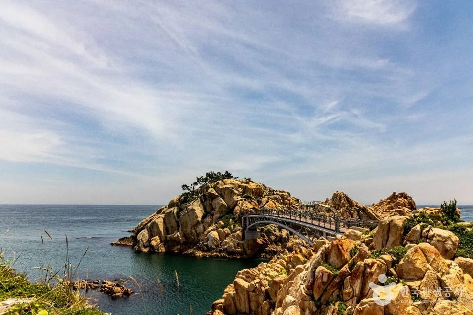
A free, always-open east-coast park linking a roughly 600-metre century-old pine approach to Ulgi Lighthouse, exposed rock formations and several signed shoreline paths of about 15–40 minutes; choose the route before arrival and check wind, waves, rain, slippery rock, bridge controls, lighting and parking rather than treating the headland as one photo stop. This catalogue page connects the stop to traveller ratings, current field reports, nearby regional anchors and sourced community corrections.
Each room follows the Seoul calendar day, then becomes a read-only visit record. Share current waits and practical tips without publishing your precise location. Group push notifications stay off during beta.
PLAN THE VISIT
The details that change the day.
Operator facts are labeled separately from Korea Era estimates and guidance.
Checked August 29, 2026. Recheck current hours, admission, closures and transport before travel.
Map pinApproximate catalogue centre
Use a Korean map app for the exact entrance and final walking route.
Mobility checkSlopes, boardwalk gaps, rocks, sand, wind and boarding conditions can change the usable route; confirm before travelling.
DAY-OF PLAN
Know the sequence before you go.
Times from the operator are kept separate from Korea Era planning guidance.
01
Choose one signed coastal route
The pine approach, lighthouse, rock headland and shoreline paths are not one short viewpoint. Pick a roughly 15–40 minute signed route that fits the group and weather.
02
Check the live gate
The bridge and auto campground list a regular second-Tuesday closure, and wind, waves, rain, inspection or crowd control can override the public park's always-open listing.
03
Return from the exposed headland
Allow enough light for wet rock, steps and the pine route, then use the exact car park or bus stop saved before the walk.
Is Daewangam Park always open even when the suspension bridge is closed?
The public park is listed year-round, but the bridge, campground, lighthouse spaces and individual paths can close independently for the regular closure, weather, maintenance or safety.
Does the hero photo guarantee I can walk onto the rocks?
No. It identifies the real headland and bridge area. Follow current barriers and staff instructions; exposed rocks can be slippery and wave-affected.
Are the operating details for Daewangam Park live?
The displayed guidance was checked August 29, 2026, but it is not a live operator feed. Open the linked official guide and a Korean map again on the day because hours, closures, tickets and transport can change.
Can a traveller correct this page?
Yes. Submit a sourced community wiki correction or a current field report; proposed facts are reviewed before becoming canonical information.
KOREA ERA SHARE
Send this without forcing a sign-up
Public link · Anyone can view
Save this for your Korea tripNo account required during beta.
TRAVELLER CHANNELS
See Daewangam Park through a traveler's own post.
Direct links only. Korea Era does not copy the post, imply endorsement or verify live conditions from it.
A free, always-open east-coast park linking a roughly 600-metre century-old pine approach to Ulgi Lighthouse, exposed rock formations and several signed shoreline paths of about 15–40 minutes; choose the route before arrival and check wind, waves, rain, slippery rock, bridge controls, lighting and parking rather than treating the headland as one photo stop. This catalogue page connects the stop to traveller ratings, current field reports, nearby regional anchors and sourced community corrections.Recheck the official source before visiting.
Read the full Wiki articleDetailed facts, sources and revision history
KOREA ERA WIKI
TRAVEL KNOWLEDGE DOCUMENT
Daewangam Park
대왕암공원A reviewed foundation built from official sources. Traveler edits are checked before publication.
Document statusReviewed foundation6 current facts0 approved edits
Global is the shared verified foundation. Country editions add approved local guidance; ratings, discussions and edit histories stay separate.
Showing the shared Global facts and Global edit history.
A free, always-open east-coast park linking a roughly 600-metre century-old pine approach to Ulgi Lighthouse, exposed rock formations and several signed shoreline paths of about 15–40 minutes; choose the route before arrival and check wind, waves, rain, slippery rock, bridge controls, lighting and parking rather than treating the headland as one photo stop. This catalogue page connects the stop to traveller ratings, current field reports, nearby regional anchors and sourced community corrections.
2. Key facts and visitor information
Region
Dong-gu · Ulsan
Korean map search
울산 대왕암공원
Outdoor access
Public park · open year-roundThe suspension bridge, lighthouse interiors, campground and other managed facilities retain their own controls.
Route choice
Signed coastal paths of roughly 15–40 minutesTimes are orientation estimates, not accessibility or bad-weather guarantees.
Bridge closure
Second Tuesday of each month listedCheck the same-day gate for weather, maintenance and crowd restrictions.
Correct destination
905 Deungdae-ro, Dong-gu · 052-209-3738Select the outdoor or tower car park before driving; the centre coordinate is not an entrance instruction.
Parking boundary
Outdoor and tower lots use the city fee tableConfirm the current rate, operating window and exit route rather than assuming all nearby roadside space is legal parking.
Accessibility
Accessible parking, toilets and a managed approach are listedThe final rock, steps and exposed coastal paths are not all step-free; ask staff for the shortest usable route.
Photo scope
Current hero shows the real rock headland, sea bridge and pine-covered coastIt does not prove today's suspension-bridge access, sea condition, lighthouse opening or visibility.
Public park · open year-round
The suspension bridge, lighthouse interiors, campground and other managed facilities retain their own controls.Checked 1/1/2026 · Korea Era editors · source
Closure or relocation
Second Tuesday of each month listed
Check the same-day gate for weather, maintenance and crowd restrictions.Checked 1/1/2026 · Korea Era editors · source
Official links
VISITKOREA · Daewangam Park · catalogue checked August 26, 2026Checked 1/1/2026 · Korea Era editors · source
3. Visit flow
01
Daylight
Choose one signed coastal route
The pine approach, lighthouse, rock headland and shoreline paths are not one short viewpoint. Pick a roughly 15–40 minute signed route that fits the group and weather.
02
Before the suspension bridge
Check the live gate
The bridge and auto campground list a regular second-Tuesday closure, and wind, waves, rain, inspection or crowd control can override the public park's always-open listing.
03
Before dusk
Return from the exposed headland
Allow enough light for wet rock, steps and the pine route, then use the exact car park or bus stop saved before the walk.
4. Traveler tips
Treat wind and wet rock as the main safety decision; never cross barriers or descend onto wave-washed stone for a photograph.
Choose Daewangam or nearby Ilsan Beach as the primary walk first; proximity does not make both a quick stop for every mobility level.
Save the exact return bus or parked-car location before entering the pine route, where several signed branches can look similar.
Search “울산 대왕암공원” in Naver Map or Kakao Map and confirm the exact entrance and return route.
Check rain, wind, waves and any access or transport notice on the day.
The catalogue coordinate is an approximate centre pin, not turn-by-turn entrance guidance.
Is Daewangam Park always open even when the suspension bridge is closed?
The public park is listed year-round, but the bridge, campground, lighthouse spaces and individual paths can close independently for the regular closure, weather, maintenance or safety.
Does the hero photo guarantee I can walk onto the rocks?
No. It identifies the real headland and bridge area. Follow current barriers and staff instructions; exposed rocks can be slippery and wave-affected.
Are the operating details for Daewangam Park live?
The displayed guidance was checked August 29, 2026, but it is not a live operator feed. Open the linked official guide and a Korean map again on the day because hours, closures, tickets and transport can change.
Can a traveller correct this page?
Yes. Submit a sourced community wiki correction or a current field report; proposed facts are reviewed before becoming canonical information.