A free waterside trail around Damyangho beneath Chuwolsan, combining long boardwalks, forest sections and reservoir views; choose a section and turnaround before checking maintenance, rain, heat, distance and rural return transport. This catalogue page connects the stop to traveller ratings, current field reports, nearby regional anchors and sourced community corrections.
Each room follows the Seoul calendar day, then becomes a read-only visit record. Share current waits and practical tips without publishing your precise location. Group push notifications stay off during beta.
PLAN THE VISIT
The details that change the day.
Operator facts are labeled separately from Korea Era estimates and guidance.
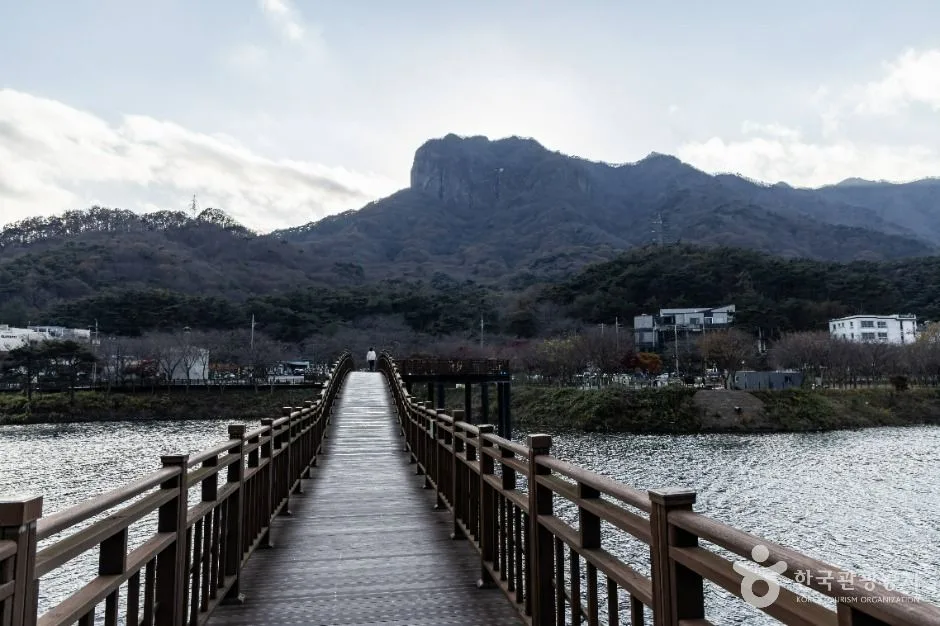
RegionDamyang · JeonnamKorean map search담양 용마루길Published route3.9 km · 2.2 km deck plus 1.7 km earthen path · about two hours ↗Current access referenceContinuously open · free admission; temporary safety closures prevailTrail boundaryBoardwalk, forest path and later route extensions do not form one universally open, lit or step-free circuitWater boundaryReservoir scenery does not grant swimming, boating, fishing or off-path accessWeather boundaryRain, ice, heat, wind and reservoir work can close or make a section unsafeTransport boundarySave the exact trailhead and return plan; rural service and taxi availability can be limitedPhoto scopeCurrent hero shows the real long wooden boardwalk crossing Damyangho toward the Chuwolsan mountain skyline
It does not prove today's open deck, full route, dry earthen path, water level, weather or return transport.
Checked August 30, 2026. Recheck current hours, admission, closures and transport before travel.
Map pinAudited official destination coordinate
The place coordinate is exact; use the named gate, parking area or accessible entrance for the final route.
Mobility checkTrail grade, steps, surface conditions, rest points and step-free alternatives are not assumed; check the official access notice.
DAY-OF PLAN
Know the sequence before you go.
Times from the operator are kept separate from Korea Era planning guidance.
01
Choose the 3.9 km route or a shorter signed section
The current record describes 3.9 km of trail, including 2.2 km of wooden deck and 1.7 km of earthen path, with an approximate two-hour walk. Continuous access and free admission do not replace a live maintenance and weather check.
02
Stay on the boardwalk and signed forest route
Damyangho is a working reservoir and the edge is not a swimming, fishing or shortcut zone. Keep children beside you, avoid closed deck sections and turn back when rain, wind or heat changes the safe route.
03
Protect daylight and the rural return connection
This is not a city loop with frequent exits. Use the same named trailhead for the return unless a verified pickup is waiting, and leave margin for the earthen section, photo stops and limited rural transport.
No. The checked record includes both wooden deck and earthen path, with changing grades and surfaces.
Does continuously open guarantee access after bad weather?
No. Safety, maintenance and reservoir conditions can override the general listing.
Are the operating details for Damyang Yongmaru Trail live?
The displayed guidance was checked August 30, 2026, but it is not a live operator feed. Open the linked official guide and a Korean map again on the day because hours, closures, tickets and transport can change.
Can a traveller correct this page?
Yes. Submit a sourced community wiki correction or a current field report; proposed facts are reviewed before becoming canonical information.
KOREA ERA SHARE
Send this without forcing a sign-up
Public link · Anyone can view
Save this for your Korea tripNo account required during beta.
TRAVELLER CHANNELS
See Damyang Yongmaru Trail through a traveler's own post.
Direct links only. Korea Era does not copy the post, imply endorsement or verify live conditions from it.
A free waterside trail around Damyangho beneath Chuwolsan, combining long boardwalks, forest sections and reservoir views; choose a section and turnaround before checking maintenance, rain, heat, distance and rural return transport. This catalogue page connects the stop to traveller ratings, current field reports, nearby regional anchors and sourced community corrections.Recheck the official source before visiting.
Read the full Wiki articleDetailed facts, sources and revision history
KOREA ERA WIKI
TRAVEL KNOWLEDGE DOCUMENT
Damyang Yongmaru Trail
담양 용마루길A reviewed foundation built from official sources. Traveler edits are checked before publication.
Document statusReviewed foundation5 current facts0 approved edits
Global is the shared verified foundation. Country editions add approved local guidance; ratings, discussions and edit histories stay separate.
Showing the shared Global facts and Global edit history.
A free waterside trail around Damyangho beneath Chuwolsan, combining long boardwalks, forest sections and reservoir views; choose a section and turnaround before checking maintenance, rain, heat, distance and rural return transport. This catalogue page connects the stop to traveller ratings, current field reports, nearby regional anchors and sourced community corrections.
Continuously open · free admission; temporary safety closures prevail
Trail boundary
Boardwalk, forest path and later route extensions do not form one universally open, lit or step-free circuit
Water boundary
Reservoir scenery does not grant swimming, boating, fishing or off-path access
Weather boundary
Rain, ice, heat, wind and reservoir work can close or make a section unsafe
Transport boundary
Save the exact trailhead and return plan; rural service and taxi availability can be limited
Photo scope
Current hero shows the real long wooden boardwalk crossing Damyangho toward the Chuwolsan mountain skylineIt does not prove today's open deck, full route, dry earthen path, water level, weather or return transport.
Continuously open · free admission; temporary safety closures prevailChecked 1/1/2026 · Korea Era editors · source
Official links
VISITKOREA · Damyang Yongmaru Trail · catalogue checked August 26, 2026Checked 1/1/2026 · Korea Era editors · source
3. Visit flow
01
Before travel
Choose the 3.9 km route or a shorter signed section
The current record describes 3.9 km of trail, including 2.2 km of wooden deck and 1.7 km of earthen path, with an approximate two-hour walk. Continuous access and free admission do not replace a live maintenance and weather check.
02
On the trail
Stay on the boardwalk and signed forest route
Damyangho is a working reservoir and the edge is not a swimming, fishing or shortcut zone. Keep children beside you, avoid closed deck sections and turn back when rain, wind or heat changes the safe route.
03
At the turnaround
Protect daylight and the rural return connection
This is not a city loop with frequent exits. Use the same named trailhead for the return unless a verified pickup is waiting, and leave margin for the earthen section, photo stops and limited rural transport.
4. Traveler tips
Start with the same trailhead you intend to return to and download the route before mobile reception becomes uncertain.
Carry water and use shoes suitable for both timber and earth; the route is longer than the hero image suggests.
Turn back early in heat, thunder, ice or fading daylight rather than relying on an unverified alternate exit.
Search “담양 용마루길” in Naver Map or Kakao Map and confirm the exact entrance and return route.
Recheck weather, trail or garden closures, last entry and seasonal conditions before departure.
The audited coordinate identifies the named destination, but the final gate, parking area and step-free entrance still need a live route check.
No. The checked record includes both wooden deck and earthen path, with changing grades and surfaces.
Does continuously open guarantee access after bad weather?
No. Safety, maintenance and reservoir conditions can override the general listing.
Are the operating details for Damyang Yongmaru Trail live?
The displayed guidance was checked August 30, 2026, but it is not a live operator feed. Open the linked official guide and a Korean map again on the day because hours, closures, tickets and transport can change.
Can a traveller correct this page?
Yes. Submit a sourced community wiki correction or a current field report; proposed facts are reviewed before becoming canonical information.