A large mountain reservoir anchoring the Yongmaru lakeside route below Chuwolsan, not one continuous public promenade; choose an exact tourist access point and check trail sections, water works, weather, parking and the rural return. This catalogue page connects the stop to traveller ratings, current field reports, nearby regional anchors and sourced community corrections.
Each room follows the Seoul calendar day, then becomes a read-only visit record. Share current waits and practical tips without publishing your precise location. Group push notifications stay off during beta.
PLAN THE VISIT
The details that change the day.
Operator facts are labeled separately from Korea Era estimates and guidance.
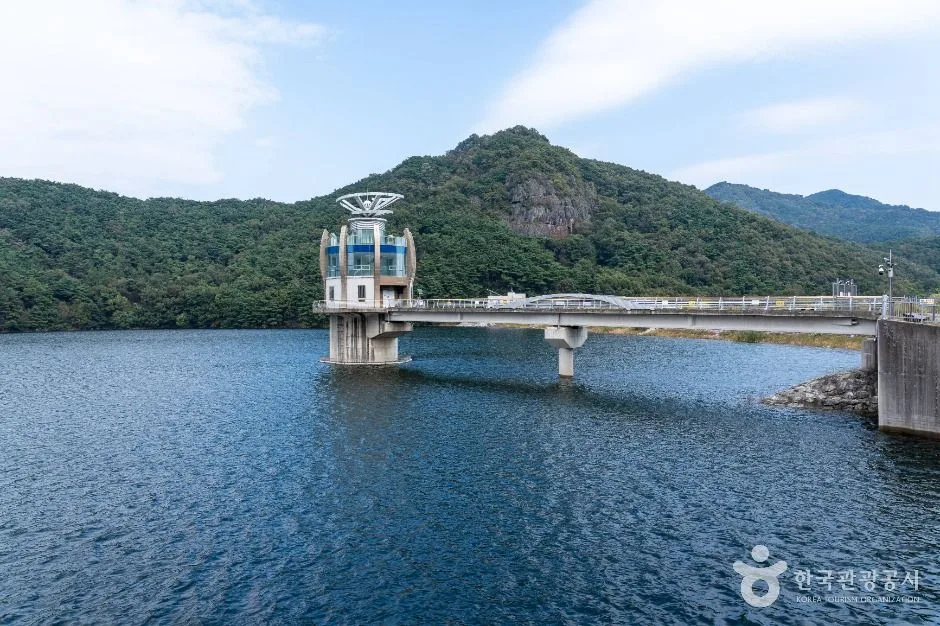
RegionDamyang · JeonnamKorean map search담양호 관광지 금성산성길 366Official destination pointDamyang County tourism coordinate near the Damyangho visitor area ↗Published visitor reference09:00-18:00 in the current tourism record ↗Map-data correctionKorea Era rejects the current TourAPI coordinate located outside Korea and uses Damyang County's official tourism map point insteadShoreline boundaryThe reservoir, dam, scenic road, Yongmaru trail and Chuwolsan approaches are separate access environmentsWater boundaryNo general swimming, boating, fishing or shoreline-entry permission is impliedTransport boundaryChoose the exact access and return before travelling; rural buses and taxis can be infrequentPhoto scopeCurrent hero shows the real Damyangho water, intake structure and forested mountain shoreline
It does not prove today's water level, public dam access, open trail, weather, parking or return transport.
Checked August 30, 2026. Recheck current hours, admission, closures and transport before travel.
Map pinAudited official destination coordinate
The place coordinate is exact; use the named gate, parking area or accessible entrance for the final route.
Mobility checkTrail grade, steps, surface conditions, rest points and step-free alternatives are not assumed; check the official access notice.
DAY-OF PLAN
Know the sequence before you go.
Times from the operator are kept separate from Korea Era planning guidance.
01
Choose a named lake access rather than navigating to open water
Damyangho is a large working reservoir surrounded by separate roads, the Chuwolsan tourist area, Yongmaru trails and water facilities. Use the official tourism-point coordinate and a named parking or trailhead.
02
Stay within the chosen public viewpoint or signed trail
A reservoir shoreline is not one continuous promenade. Do not enter dam works, service roads, steep banks or water without explicit permission, and follow any maintenance or water-level barrier.
03
Reconfirm the rural return before extending along the shore
The tourism record gives a broad 09:00-18:00 visitor reference, but individual trails and facilities differ. Protect daylight, weather and the last practical bus or taxi.
No. It is an official tourism destination point; choose the named trail, viewpoint or facility needed for the final route.
Why does Korea Era not use the current TourAPI coordinate?
That source record currently places Damyangho outside Korea. The catalogue uses Damyang County's official tourism map coordinate instead.
Are the operating details for Damyangho Lake live?
The displayed guidance was checked August 30, 2026, but it is not a live operator feed. Open the linked official guide and a Korean map again on the day because hours, closures, tickets and transport can change.
Can a traveller correct this page?
Yes. Submit a sourced community wiki correction or a current field report; proposed facts are reviewed before becoming canonical information.
KOREA ERA SHARE
Send this without forcing a sign-up
Public link · Anyone can view
Save this for your Korea tripNo account required during beta.
TRAVELLER CHANNELS
See Damyangho Lake through a traveler's own post.
Direct links only. Korea Era does not copy the post, imply endorsement or verify live conditions from it.
A large mountain reservoir anchoring the Yongmaru lakeside route below Chuwolsan, not one continuous public promenade; choose an exact tourist access point and check trail sections, water works, weather, parking and the rural return. This catalogue page connects the stop to traveller ratings, current field reports, nearby regional anchors and sourced community corrections.Recheck the official source before visiting.
Read the full Wiki articleDetailed facts, sources and revision history
KOREA ERA WIKI
TRAVEL KNOWLEDGE DOCUMENT
Damyangho Lake
담양호A reviewed foundation built from official sources. Traveler edits are checked before publication.
Document statusReviewed foundation4 current facts0 approved edits
Global is the shared verified foundation. Country editions add approved local guidance; ratings, discussions and edit histories stay separate.
Showing the shared Global facts and Global edit history.
A large mountain reservoir anchoring the Yongmaru lakeside route below Chuwolsan, not one continuous public promenade; choose an exact tourist access point and check trail sections, water works, weather, parking and the rural return. This catalogue page connects the stop to traveller ratings, current field reports, nearby regional anchors and sourced community corrections.
Korea Era rejects the current TourAPI coordinate located outside Korea and uses Damyang County's official tourism map point instead
Shoreline boundary
The reservoir, dam, scenic road, Yongmaru trail and Chuwolsan approaches are separate access environments
Water boundary
No general swimming, boating, fishing or shoreline-entry permission is implied
Transport boundary
Choose the exact access and return before travelling; rural buses and taxis can be infrequent
Photo scope
Current hero shows the real Damyangho water, intake structure and forested mountain shorelineIt does not prove today's water level, public dam access, open trail, weather, parking or return transport.
VISITKOREA · Damyangho Lake · catalogue checked August 26, 2026Checked 1/1/2026 · Korea Era editors · source
3. Visit flow
01
Before travel
Choose a named lake access rather than navigating to open water
Damyangho is a large working reservoir surrounded by separate roads, the Chuwolsan tourist area, Yongmaru trails and water facilities. Use the official tourism-point coordinate and a named parking or trailhead.
02
At the lake
Stay within the chosen public viewpoint or signed trail
A reservoir shoreline is not one continuous promenade. Do not enter dam works, service roads, steep banks or water without explicit permission, and follow any maintenance or water-level barrier.
03
Before leaving
Reconfirm the rural return before extending along the shore
The tourism record gives a broad 09:00-18:00 visitor reference, but individual trails and facilities differ. Protect daylight, weather and the last practical bus or taxi.
4. Traveler tips
Navigate to a named visitor area or Yongmaru trailhead, never to the visual centre of the lake.
Download the route and save a return contact before leaving Damyang town.
Treat barriers around water infrastructure as firm even when a viewpoint appears close beyond them.
Search “담양호 관광지 금성산성길 366” in Naver Map or Kakao Map and confirm the exact entrance and return route.
Recheck weather, trail or garden closures, last entry and seasonal conditions before departure.
The audited coordinate identifies the named destination, but the final gate, parking area and step-free entrance still need a live route check.
No. It is an official tourism destination point; choose the named trail, viewpoint or facility needed for the final route.
Why does Korea Era not use the current TourAPI coordinate?
That source record currently places Damyangho outside Korea. The catalogue uses Damyang County's official tourism map coordinate instead.
Are the operating details for Damyangho Lake live?
The displayed guidance was checked August 30, 2026, but it is not a live operator feed. Open the linked official guide and a Korean map again on the day because hours, closures, tickets and transport can change.
Can a traveller correct this page?
Yes. Submit a sourced community wiki correction or a current field report; proposed facts are reviewed before becoming canonical information.