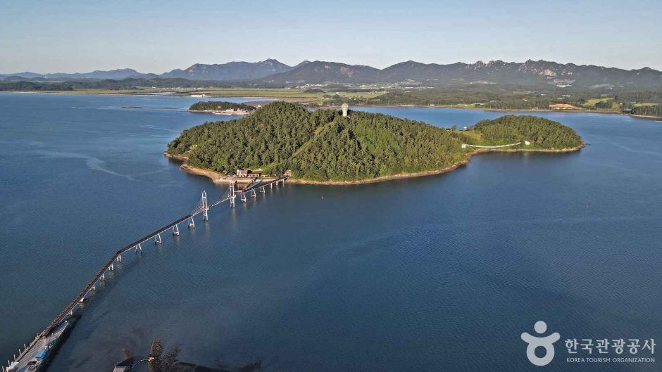
Gau-do is Gangjin's only inhabited island, linked by the 438-metre Jeodu and 716-metre Mangho bridges and a roughly 2.5-kilometre coastal trail. This pin marks the Doam-side approach, so choose the bridge, allow about 90 minutes for the island walk and recheck wind, lighting and the final rural connection. This catalogue page connects the stop to traveller ratings, current field reports, nearby regional anchors and sourced community corrections.
Help the next traveller understand Gau-do Suspension Bridge.
Visitor insight appears after a real contribution, so empty counters never stand in for activity.
Ask a question or share a current update
Recent traveler reports
Answered by travellers, not checked by us. The verified facts above carry the date we confirmed them.
Loading traveller reports…
Questions about this place
Drafts can be restored in this tab and sign-in session for 24 hours. Saving does not post them; expired copies are not automatically deleted.
Question request recovery is not ready. Recheck your account and saved draft before posting.
TODAY AT THIS PLACE
Ask people visiting Gau-do Suspension Bridge today.
Each room follows the Seoul calendar day, then becomes a read-only visit record. Share current waits and practical tips without publishing your precise location. Group push notifications stay off during beta.
PLAN THE VISIT
Good to know before you visit
Operator facts are labeled separately from Korea Era estimates and guidance.
A reviewed foundation built from official sources. Traveler edits are checked before publication.
RegionGangjin · JeonnamKorean map search전남광주통합특별시 강진군 도암면 신기리 가우도 출렁다리 34.5288298365 126.7717213363Current accessContinuously accessible · open year-round ↗Bridge choicesMangho 716 m from Doam · Jeodu 438 m from Daegu
Confirm the matching mainland entrance and parking area before navigation.
Island trailAbout 2.5 km · approximately 1 hour 30 minutes
The estimate does not include a long meal, photo queue or transport wait.
Exact published arrivalSinggi-ri, Doam-myeon, Gangjin
No street number is published; the audited coordinate identifies this named bridge approach.
ParkingAvailable
Live capacity, bridge-side choice and traffic control are not guaranteed.
Photo scopeReal aerial view of Gau-do, its forested shoreline and the long bridges crossing Gangjin Bay
It does not prove today's bridge lighting, wind, trail condition, parking capacity or final transport.
Checked September 8, 2026. Recheck current hours, admission, closures and transport before travel.
Map pinAudited official destination coordinate
The place coordinate is exact; use the named gate, parking area or accessible entrance for the final route.
Mobility checkSlopes, boardwalk gaps, rocks, sand, wind and boarding conditions can change the usable route; confirm before travelling.
DAY-OF PLAN
Know the sequence before you go.
Times from the operator are kept separate from Korea Era planning guidance.
01
Choose the Doam or Daegu bridge
Gau-do has two mainland links: the 716-metre Mangho bridge from Doam and the 438-metre Jeodu bridge from Daegu. This catalogue coordinate marks the Doam-side published arrival, not both car parks.
02
Walk the 2.5-kilometre coast trail
The Together Sea trail circles the inhabited island. Distance, slopes, heat, wind and stops make it a real walk rather than an instant bridge photograph.
03
Set the return first
Bridge lighting can add an evening view, but illumination, weather and rural bus or taxi availability must be checked independently.
No. It is the current official coordinate for the Doam-side bridge record; choose Mangho or Jeodu and navigate to the matching mainland approach.
Is the bridge walk the whole visit?
No. The published island trail is about 2.5 kilometres and roughly 90 minutes, before meals, stops or transport waits.
Are the operating details for Gau-do Suspension Bridge live?
The displayed guidance was checked September 8, 2026, but it is not a live operator feed. Open the linked official guide and a Korean map again on the day because hours, closures, tickets and transport can change.
Can a traveller correct this page?
Yes. Submit a sourced community wiki correction or a current field report; proposed facts are reviewed before becoming canonical information.
KOREA ERA SHARE
Send this without forcing a sign-up
Public link · Anyone can view
Save this for your Korea tripNo account required during beta.
TRAVELLER CHANNELS
See Gau-do Suspension Bridge through a traveler's own post.
Direct links only. Korea Era does not copy the post, imply endorsement or verify live conditions from it.
Gau-do is Gangjin's only inhabited island, linked by the 438-metre Jeodu and 716-metre Mangho bridges and a roughly 2.5-kilometre coastal trail. This pin marks the Doam-side approach, so choose the bridge, allow about 90 minutes for the island walk and recheck wind, lighting and the final rural connection. This catalogue page connects the stop to traveller ratings, current field reports, nearby regional anchors and sourced community corrections.Recheck the official source before visiting.
Read the full Wiki articleDetailed facts, sources and revision history
KOREA ERA WIKI
TRAVEL KNOWLEDGE DOCUMENT
Gau-do Suspension Bridge
가우도 출렁다리A reviewed foundation built from official sources. Traveler edits are checked before publication.
Document statusReviewed foundation5 current facts0 recent approved edits
Global is the shared verified foundation. Country editions add approved local guidance; ratings, discussions and edit histories stay separate.
Showing the shared Global facts and Global edit history.
Gau-do is Gangjin's only inhabited island, linked by the 438-metre Jeodu and 716-metre Mangho bridges and a roughly 2.5-kilometre coastal trail. This pin marks the Doam-side approach, so choose the bridge, allow about 90 minutes for the island walk and recheck wind, lighting and the final rural connection. This catalogue page connects the stop to traveller ratings, current field reports, nearby regional anchors and sourced community corrections.
Mangho 716 m from Doam · Jeodu 438 m from DaeguConfirm the matching mainland entrance and parking area before navigation.
Island trail
About 2.5 km · approximately 1 hour 30 minutesThe estimate does not include a long meal, photo queue or transport wait.
Exact published arrival
Singgi-ri, Doam-myeon, GangjinNo street number is published; the audited coordinate identifies this named bridge approach.
Parking
AvailableLive capacity, bridge-side choice and traffic control are not guaranteed.
Photo scope
Real aerial view of Gau-do, its forested shoreline and the long bridges crossing Gangjin BayIt does not prove today's bridge lighting, wind, trail condition, parking capacity or final transport.
Audited official destination coordinateThe place coordinate is exact; use the named gate, parking area or accessible entrance for the final route.
Mobility check
Slopes, boardwalk gaps, rocks, sand, wind and boarding conditions can change the usable route; confirm before travelling.
3. Visit flow
01
Before the bay transfer
Choose the Doam or Daegu bridge
Gau-do has two mainland links: the 716-metre Mangho bridge from Doam and the 438-metre Jeodu bridge from Daegu. This catalogue coordinate marks the Doam-side published arrival, not both car parks.
02
Allow about 90 minutes
Walk the 2.5-kilometre coast trail
The Together Sea trail circles the inhabited island. Distance, slopes, heat, wind and stops make it a real walk rather than an instant bridge photograph.
03
Before dusk or the last connection
Set the return first
Bridge lighting can add an evening view, but illumination, weather and rural bus or taxi availability must be checked independently.
4. Traveler tips
Save the Korean name and selected bridge approach before leaving because the two mainland entrances are not interchangeable.
Carry water and sun or wind protection for the exposed coastal trail, especially outside the shaded island interior.
Keep the last return connection and sufficient daylight in reserve rather than relying on decorative bridge lighting.
Search “전남광주통합특별시 강진군 도암면 신기리 가우도 출렁다리 34.5288298365 126.7717213363” in Naver Map or Kakao Map and confirm the exact entrance and return route.
Check rain, wind, waves and any access or transport notice on the day.
The audited coordinate identifies the named destination, but the final gate, parking area and step-free entrance still need a live route check.
No. It is the current official coordinate for the Doam-side bridge record; choose Mangho or Jeodu and navigate to the matching mainland approach.
Is the bridge walk the whole visit?
No. The published island trail is about 2.5 kilometres and roughly 90 minutes, before meals, stops or transport waits.
Are the operating details for Gau-do Suspension Bridge live?
The displayed guidance was checked September 8, 2026, but it is not a live operator feed. Open the linked official guide and a Korean map again on the day because hours, closures, tickets and transport can change.
Can a traveller correct this page?
Yes. Submit a sourced community wiki correction or a current field report; proposed facts are reviewed before becoming canonical information.