Ulleungdo's broad volcanic basin is continuously accessible and currently free, but the basin village, farm lanes, trailheads, observatory, restaurants, bus return and mountain routes must be planned separately around weather and daylight. This catalogue page connects the stop to traveller ratings, current field reports, nearby regional anchors and sourced community corrections.
Each room follows the Seoul calendar day, then becomes a read-only visit record. Share current waits and practical tips without publishing your precise location. Group push notifications stay off during beta.
PLAN THE VISIT
The details that change the day.
Operator facts are labeled separately from Korea Era estimates and guidance.
The official catalogue figure is orientation only, not live vacancy or coach suitability.
Listed facilitiesTrails · benches · observatory
Individual condition, accessibility and opening are not guaranteed.
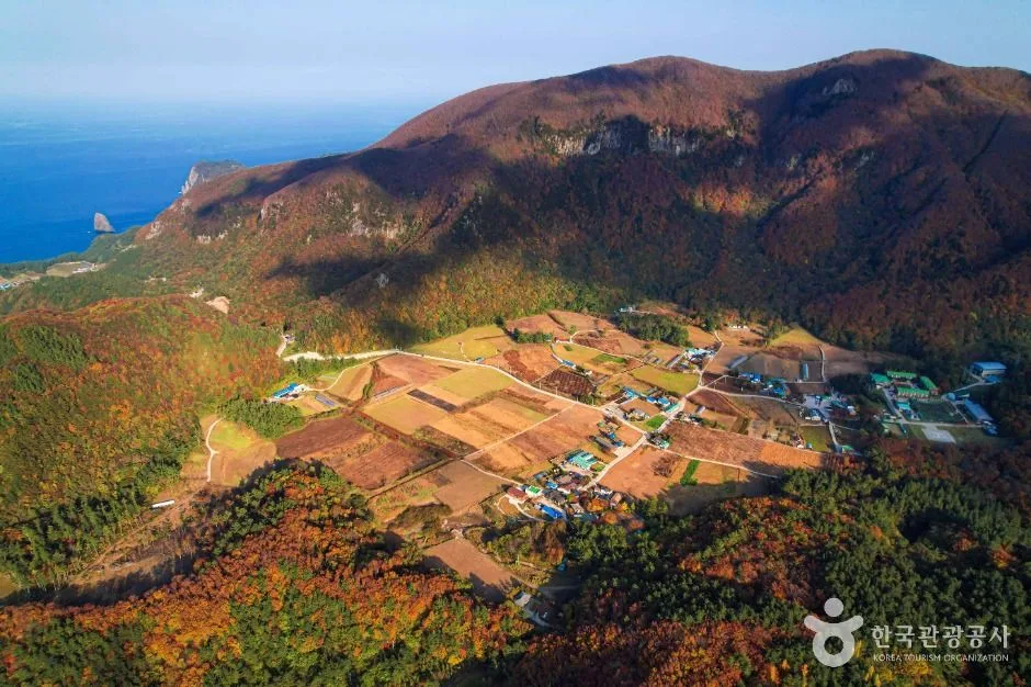
Living landscapeUse public lanes and keep out of fields, yards and working farm areasTrail boundaryBasin access does not open every Seonginbong, Albong or forest routeSeason boundaryCrops, flowers, snow, visibility and restaurant operation change independentlyPhoto scopeThe reviewed hero is a real broad view of Nari Basin's volcanic farmland, village plots and steep forested mountain walls
It does not prove today's crop or flower condition, clear summit, open trail, operating restaurant, available bus, dry surface, public field access or parking vacancy.
Checked September 2, 2026. Recheck current hours, admission, closures and transport before travel.
Map pinAudited official destination coordinate
The place coordinate is exact; use the named gate, parking area or accessible entrance for the final route.
Mobility checkTrail grade, steps, surface conditions, rest points and step-free alternatives are not assumed; check the official access notice.
DAY-OF PLAN
Know the sequence before you go.
Times from the operator are kept separate from Korea Era planning guidance.
01
Save the bus or vehicle return
The basin is inland and high on Ulleungdo. Confirm the current island bus direction, final useful return, taxi fallback and the exact restaurant or trailhead before travel.
02
Choose village, observatory or trail
The current record lists trails, benches and an observatory, but Nari's farm lanes, private fields, restaurants and mountain routes are not one continuous public circuit.
03
Check weather, daylight and trail control
Do not infer an open Seonginbong or Albong route from continuous basin access. Turn back for fog, wind, heavy rain, snow, ice or the protected return.
Does continuous access mean every mountain trail is open?
No. The basin landscape and each mountain route have separate weather, maintenance, daylight and safety controls.
Can visitors walk through the farm plots?
Only use clearly public lanes and signed routes. Fields, yards and working agricultural areas are not public shortcuts.
Are the operating details for Nari Basin live?
The displayed guidance was checked September 2, 2026, but it is not a live operator feed. Open the linked official guide and a Korean map again on the day because hours, closures, tickets and transport can change.
Can a traveller correct this page?
Yes. Submit a sourced community wiki correction or a current field report; proposed facts are reviewed before becoming canonical information.
KOREA ERA SHARE
Send this without forcing a sign-up
Public link · Anyone can view
Save this for your Korea tripNo account required during beta.
TRAVELLER CHANNELS
See Nari Basin through a traveler's own post.
Direct links only. Korea Era does not copy the post, imply endorsement or verify live conditions from it.
Ulleungdo's broad volcanic basin is continuously accessible and currently free, but the basin village, farm lanes, trailheads, observatory, restaurants, bus return and mountain routes must be planned separately around weather and daylight. This catalogue page connects the stop to traveller ratings, current field reports, nearby regional anchors and sourced community corrections.Recheck the official source before visiting.
Read the full Wiki articleDetailed facts, sources and revision history
KOREA ERA WIKI
TRAVEL KNOWLEDGE DOCUMENT
Nari Basin
나리분지A reviewed foundation built from official sources. Traveler edits are checked before publication.
Document statusReviewed foundation4 current facts0 approved edits
Global is the shared verified foundation. Country editions add approved local guidance; ratings, discussions and edit histories stay separate.
Showing the shared Global facts and Global edit history.
Ulleungdo's broad volcanic basin is continuously accessible and currently free, but the basin village, farm lanes, trailheads, observatory, restaurants, bus return and mountain routes must be planned separately around weather and daylight. This catalogue page connects the stop to traveller ratings, current field reports, nearby regional anchors and sourced community corrections.
20 vehicles · freeThe official catalogue figure is orientation only, not live vacancy or coach suitability.
Listed facilities
Trails · benches · observatoryIndividual condition, accessibility and opening are not guaranteed.
Living landscape
Use public lanes and keep out of fields, yards and working farm areas
Trail boundary
Basin access does not open every Seonginbong, Albong or forest route
Season boundary
Crops, flowers, snow, visibility and restaurant operation change independently
Photo scope
The reviewed hero is a real broad view of Nari Basin's volcanic farmland, village plots and steep forested mountain wallsIt does not prove today's crop or flower condition, clear summit, open trail, operating restaurant, available bus, dry surface, public field access or parking vacancy.
VISITKOREA · Nari Basin · catalogue checked August 26, 2026Checked 1/1/2026 · Korea Era editors · source
3. Visit flow
01
Before leaving the port area
Save the bus or vehicle return
The basin is inland and high on Ulleungdo. Confirm the current island bus direction, final useful return, taxi fallback and the exact restaurant or trailhead before travel.
02
At the basin
Choose village, observatory or trail
The current record lists trails, benches and an observatory, but Nari's farm lanes, private fields, restaurants and mountain routes are not one continuous public circuit.
03
Before a mountain extension
Check weather, daylight and trail control
Do not infer an open Seonginbong or Albong route from continuous basin access. Turn back for fog, wind, heavy rain, snow, ice or the protected return.
4. Traveler tips
Keep the return transport before beginning a trail because the basin is not a short walk back to an island port.
Ask before photographing residents, homes, farm work or produce at close range and never enter a field for composition.
Carry warmer and wetter-weather layers than the harbour forecast suggests because the basin can hold cloud and cold air.
Search “나리분지 경상북도 울릉군 북면 나리길” in Naver Map or Kakao Map and confirm the exact entrance and return route.
Recheck weather, trail or garden closures, last entry and seasonal conditions before departure.
The audited coordinate identifies the named destination, but the final gate, parking area and step-free entrance still need a live route check.
Does continuous access mean every mountain trail is open?
No. The basin landscape and each mountain route have separate weather, maintenance, daylight and safety controls.
Can visitors walk through the farm plots?
Only use clearly public lanes and signed routes. Fields, yards and working agricultural areas are not public shortcuts.
Are the operating details for Nari Basin live?
The displayed guidance was checked September 2, 2026, but it is not a live operator feed. Open the linked official guide and a Korean map again on the day because hours, closures, tickets and transport can change.
Can a traveller correct this page?
Yes. Submit a sourced community wiki correction or a current field report; proposed facts are reviewed before becoming canonical information.