A continuously accessible and free west-coast landscape route whose forest trail, cliff viewpoint, protected juniper habitat, optional monorail, return path and transport each keep separate weather, maintenance and operating decisions. This catalogue page connects the stop to traveller ratings, current field reports, nearby regional anchors and sourced community corrections.
Ask people visiting Taeha Coastal Walk and Daepunggam today.
Each room follows the Seoul calendar day, then becomes a read-only visit record. Share current waits and practical tips without publishing your precise location. Group push notifications stay off during beta.
PLAN THE VISIT
The details that change the day.
Operator facts are labeled separately from Korea Era estimates and guidance.
RegionUlleung · GyeongbukKorean map search태하 해안산책로 대풍감 경상북도 울릉군 서면 태하리Exact destinationTaeha-ri, Seo-myeon, Ulleung ↗Coastal-route baselineContinuously accessible catalogue listing · freeMonorail boundaryOptional transport is separately ticketed and can close independentlyParking boundaryParking listed as available
The record does not prove live vacancy, final-return access or coach suitability.
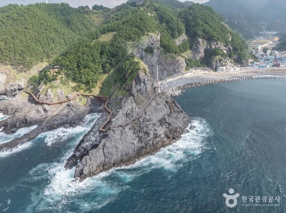
Habitat boundaryStay on signed paths around protected juniper and cliff vegetationCliff boundaryWind, rain, lightning, fallen trees, inspection and barriers override accessReturn boundaryConfirm descent path, transport and daylight before committing uphillPhoto scopeThe reviewed hero is a real elevated view across Taeha's forested cliffs, coastal route and blue sea near Daepunggam
It does not prove today's monorail, open complete path, low wind, safe cliff, clear view, accessible circuit, operating bus, protected-habitat access or parking vacancy.
Is the monorail included with the free coastal route?
No. It is a separate operation with its own ticket, inspection, weather and final-use conditions.
Does continuous access guarantee the full cliff circuit?
No. Individual forest and coastal sections can close for wind, rain, maintenance, fallen trees or safety barriers.
Are the operating details for Taeha Coastal Walk and Daepunggam live?
The displayed guidance was checked September 2, 2026, but it is not a live operator feed. Open the linked official guide and a Korean map again on the day because hours, closures, tickets and transport can change.
Can a traveller correct this page?
Yes. Submit a sourced community wiki correction or a current field report; proposed facts are reviewed before becoming canonical information.
KOREA ERA SHARE
Send this without forcing a sign-up
Public link · Anyone can view
Save this for your Korea tripNo account required during beta.
TRAVELLER CHANNELS
See Taeha Coastal Walk and Daepunggam through a traveler's own post.
Direct links only. Korea Era does not copy the post, imply endorsement or verify live conditions from it.
A continuously accessible and free west-coast landscape route whose forest trail, cliff viewpoint, protected juniper habitat, optional monorail, return path and transport each keep separate weather, maintenance and operating decisions. This catalogue page connects the stop to traveller ratings, current field reports, nearby regional anchors and sourced community corrections.Recheck the official source before visiting.
Read the full Wiki articleDetailed facts, sources and revision history
KOREA ERA WIKI
TRAVEL KNOWLEDGE DOCUMENT
Taeha Coastal Walk and Daepunggam
태하 해안산책로 및 대풍감A reviewed foundation built from official sources. Traveler edits are checked before publication.
Document statusReviewed foundation4 current facts0 approved edits
Global is the shared verified foundation. Country editions add approved local guidance; ratings, discussions and edit histories stay separate.
Showing the shared Global facts and Global edit history.
A continuously accessible and free west-coast landscape route whose forest trail, cliff viewpoint, protected juniper habitat, optional monorail, return path and transport each keep separate weather, maintenance and operating decisions. This catalogue page connects the stop to traveller ratings, current field reports, nearby regional anchors and sourced community corrections.
Optional transport is separately ticketed and can close independently
Parking boundary
Parking listed as availableThe record does not prove live vacancy, final-return access or coach suitability.
Habitat boundary
Stay on signed paths around protected juniper and cliff vegetation
Cliff boundary
Wind, rain, lightning, fallen trees, inspection and barriers override access
Return boundary
Confirm descent path, transport and daylight before committing uphill
Photo scope
The reviewed hero is a real elevated view across Taeha's forested cliffs, coastal route and blue sea near DaepunggamIt does not prove today's monorail, open complete path, low wind, safe cliff, clear view, accessible circuit, operating bus, protected-habitat access or parking vacancy.
Is the monorail included with the free coastal route?
No. It is a separate operation with its own ticket, inspection, weather and final-use conditions.
Does continuous access guarantee the full cliff circuit?
No. Individual forest and coastal sections can close for wind, rain, maintenance, fallen trees or safety barriers.
Are the operating details for Taeha Coastal Walk and Daepunggam live?
The displayed guidance was checked September 2, 2026, but it is not a live operator feed. Open the linked official guide and a Korean map again on the day because hours, closures, tickets and transport can change.
Can a traveller correct this page?
Yes. Submit a sourced community wiki correction or a current field report; proposed facts are reviewed before becoming canonical information.