KOREA ERA · LIVE TRAVEL BOARDSeoul detail · events across Korea · Busan and Jeju city hubs
Korea Era

Nature reset · TOPIC 37 / 200 · CHECKED 2026-08-22

A southbound Gangneung coast day — Gyeongpo to Anmok

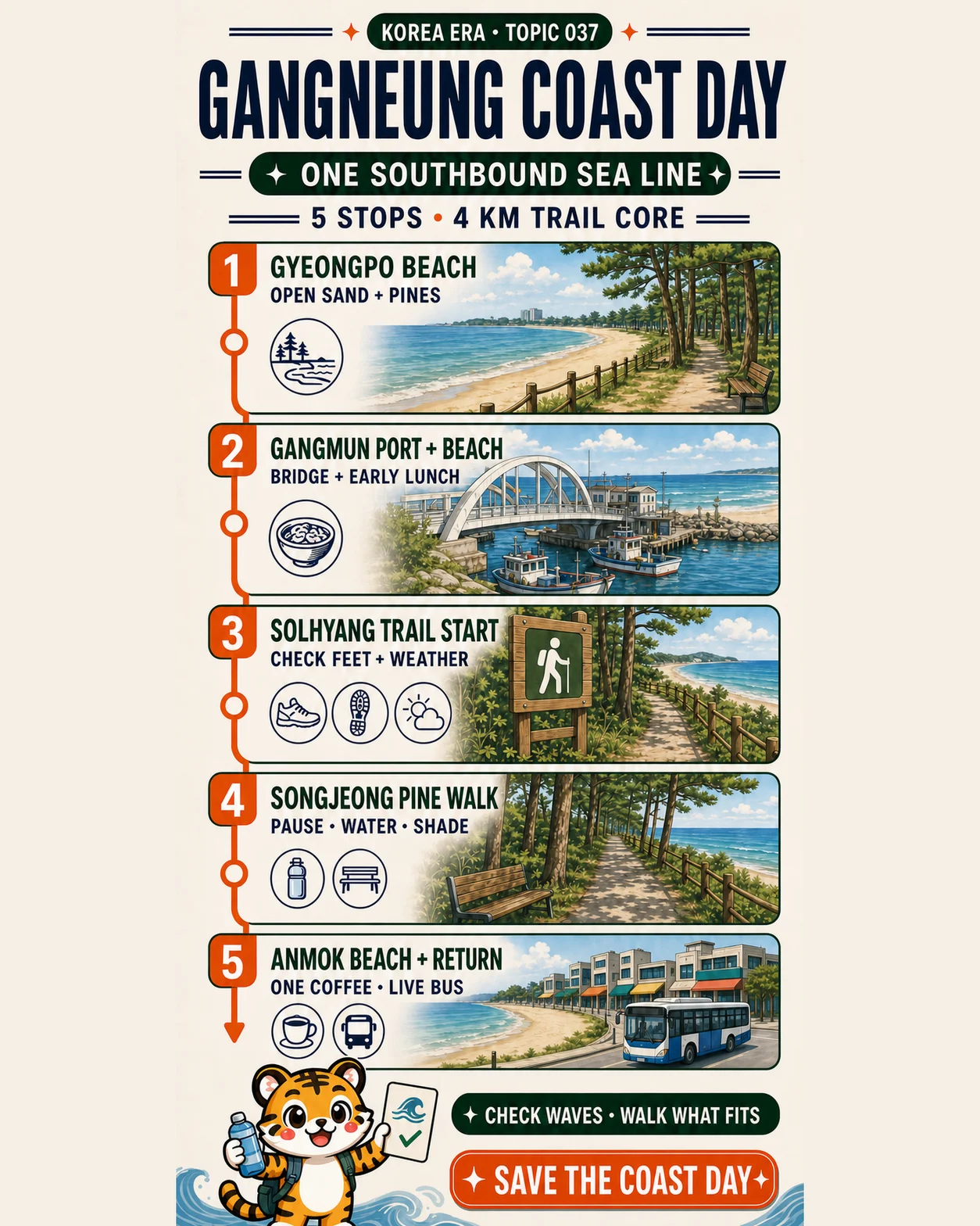
강릉 바다 따라 하루 여행하기Gyeongpo sand, Gangmun bridge and port, the official approximately 4 km Solhyang trail through Songjeong pines, then Anmok coffee and a live-checked return — one southbound sea line.
Five coast stops in one direction, with the 4 km label limited to the official trail core and every wave, surface and return checked live.
Korea Era tiger presenting a five-stop Gangneung coast route from Gyeongpo to Anmok
Illustrated overview · live details and sources are listed below.
TIME
1 day · 5 stops · approximately 4 km official trail core
BUDGET
Early lunch + one coffee + live bus or taxi fare
BEST FOR
Coast walkers · first Gangneung trip · flexible pace
MOVE
Walk the official 4 km core · live bus or taxi at the edges

THE EDITED ROUTE

5 stops, each with a reason.

Times create a useful rhythm. They are not promises about opening hours or travel time.
01

ONE SOUTHBOUND SEA LINE

Open sand to shaded pines to Anmok

Suggested times are pacing anchors, not access hours or bus promises. The approximately 4 km figure applies only to the official Gangmun–Songjeong–Anmok Solhyang Healing Coastal Trail core, not the whole day.
  1. 01

    Gyeongpo Beach

    경포해변

    Begin with the widest-feeling sand and pine edge while the day is cool. Keep the visit on stable public surfaces and decide the Gangmun transfer from live walking directions rather than assuming one continuous boardwalk.

    Shore visit is free; managed swimming services are seasonal
  2. 02

    Gangmun Port and Beach

    강문항과 강문해변

    Use the bridge-and-port area as a visual pause and take an early lunch before the trail core. Stay away from breakwater edges, working harbor space and wave-washed rocks.

    Check the posted menu and total before orderingSeafood and raw-fish venues vary; confirm ingredients, cross-contact, preparation charges and a non-seafood fallback
  3. 03

    Solhyang Healing Coastal Trail start

    솔향힐링해안산책로 시작점

    Enter the signed coastal trail near Gangmun and treat its approximately 4 km to Anmok as a core you may shorten. Shoes are the default; barefoot walking is optional and unsuitable for broken skin or some foot conditions.

    Free; carry water and keep a live exit plan
  4. 04

    Songjeong pine walk

    송정 솔숲 산책

    Pause in the pine-backed middle section, drink water and reassess wind, heat, feet and return time. Follow signed public paths without entering dunes, planted areas or unstable shore edges.

    Free; rest and shorten the route whenever needed
  5. 05

    Anmok Beach, one coffee and return

    안목해변 · 커피 한 잔 · 귀가

    Finish the southbound line with one cafe chosen for today's priority, then open the official live bus system before ordering. Protect a reserved train or bus with a personal buffer and a taxi fallback.

    One drink + live bus or taxi fare; no cafe-racing targetConfirm caffeine, milk, allergens, cross-contact, size and final price at the chosen cafe

ROUTE MAP

A southbound Gangneung coast day — Gyeongpo to Anmok

5 saved stops
Route map · ordered stops and live map links are ready below.
ONE SOUTHBOUND SEA LINE
The line shows editorial order, not turn-by-turn navigation. Check live routing before leaving.

YOUR DAY, IN PROGRESS

Carry this edit through the day.

Mark each stop as you go. Your progress stays on this device.
Korea Era tiger mascot celebrating a completed route
0of 5 stops
0%

ONE SOUTHBOUND SEA LINE

No account needed. This checklist is saved only in this browser.

MAKE IT YOUR TRIP

Add the full route to your trip.

Korea Era adds all 5 ordered stops to one editable trip. Choose the day you plan to go.

EDITOR’S NOTES

The choices that make this edit work.

ROUTE LOGIC

Keep moving south

Gyeongpo is the opening, Gangmun is the lunch hinge, and the signed trail carries the day through Songjeong to Anmok. Do not add a north-coast or mountain detour to the same day.

One direction · five distinct stops
DISTANCE LABEL

4 km means the trail core

The city describes the Solhyang Healing Coastal Trail from Gangmun through Songjeong to Anmok as approximately 4 km. Gyeongpo access, lunch detours and cafe walking are extra.

Never sell 4 km as the whole day
WAVE RULE

The sea sets the boundary

A beach visit does not promise swimming. Wind waves, lightning, heat, cold, slippery surfaces and official restrictions can shorten or cancel the shore portion.

Check KMA and local notices live
EXIT PLAN

Reserve the return first

Old tourism articles are useful context, not a timetable. Check the official Gangneung bus system at Anmok and keep taxi time and fare as the fallback.

Live stop · direction · arrival

BEFORE YOU GO

What can still change

  • The five times are pacing suggestions, not opening hours, access promises or a bus timetable. Start later, shorten the walk or leave early when weather, mobility or a reserved return requires it.
  • The approximately 4 km distance applies only to the official Gangmun–Songjeong–Anmok Solhyang Healing Coastal Trail core. It excludes the Gyeongpo start, transfers, lunch detours, cafe walking and any route-finding error.
  • Gyeongpo and Gangmun are linked within the same coast area, including the Sotdae Bridge context, but surfaces, bridge access and detours can change. Use live walking directions or a short bus or taxi; do not assume a continuous boardwalk.
  • A beach page showing year-round access does not mean managed swimming is available. Enter the water only in a currently designated zone, during the posted season and hours, with lifeguard and local notices checked live.
  • Check Korea Meteorological Administration warnings for wind, wind waves, lightning, heavy rain, heat, cold and other hazards. An official warning or on-site restriction overrides the saved route and campaign image.
  • Do not chase waves, climb wet rocks or enter working harbor, breakwater or fishing zones for a photo. Keep back from spray and use stable public surfaces.
  • Choose an early Gangmun lunch from current posted menus. Seafood and raw-fish businesses vary in price, preparation charges, ingredients and cross-contact; a non-seafood meal is a valid route choice.
  • The signed 4 km trail is a planning core, not a fitness test. Follow current wayfinding, use a signed exit or local transport when needed, and never force the full walk through pain, heat or worsening weather.
  • Barefoot walking is optional, never a route requirement. Do not walk barefoot with broken skin, and seek medical advice first if diabetes or another foot condition increases injury or infection risk; wear supportive shoes when uncertain.
  • Carry water, sun protection and a charged phone. Pace the exposed sections for heat and wind, use shade and benches when available, and check your feet before continuing.
  • Songjeong is officially described as a roughly 700 m beach with a pine forest. Stay on public paths, protect dunes and vegetation, take all litter out and do not treat the pine edge as a campsite.
  • At Anmok, choose one cafe by coffee, view, access or quiet — not a cafe race. Topic 036 contains the full menu, caffeine, allergen, last-order and one-cup field guide.
  • The city has described the Anmok Travel Lounge with tourist help, rest space, lockers, restrooms and other facilities. Confirm the current opening hours, capacity and exact service before relying on it.
  • Older SEA TEA or tourism articles can explain the coast connection but are not a current bus timetable. Use the official Gangneung Bus Information System for the stop direction and live arrival, with a taxi fallback.
  • Protect the return before the final coffee. Calculate departure backwards from a reserved train or intercity bus, the live local transfer and your personal buffer; one more shoreline stop is optional.
  • Accessibility differs by sand, promenade, bridge, signed trail, cafe and transport stop. Confirm the exact surface, slope, threshold, toilet, rest point and assistance needed through current official information.
  • Call 112 for police, 119 for fire or medical emergency and 1330 for multilingual travel support. Save the Korean place names and your accommodation address offline.

USEFUL KOREAN

3 phrases for this edit

이 길이 안목해변까지 이어져요?
Does this path continue to Anmok Beach?
가장 가까운 버스 정류장이 어디예요?
Where is the nearest bus stop?
해수욕이 가능한 구역이에요?
Is this a designated swimming area?

CHECKED SOURCES

The illustration is not the source.

Changing facts are linked to the public body or tourism operator responsible for them.
  1. Gangneung City · Solhyang Healing Coastal TrailOfficial approximately 4 km Gangmun–Songjeong–Anmok route, endpoints, foot-washing context and barefoot-health warning.Open official source ↗
  2. Gangneung City · SEA TEA and pine walkOfficial Songjeong–Gangmun pine-walk context; dated transport details are not reused as a current timetable.Open official source ↗
  3. Gangneung City · autonomous coast routeOfficial background on the coast connection; operations are explicitly treated as live-only.Open official source ↗
  4. Gangneung City · recommended walkingOfficial Gyeongpo and coast-to-Anmok walking context.Open official source ↗
  5. Gangneung City · tourism overviewOfficial destination overview and regional context.Open official source ↗
  6. Gangneung City · seasonal beachesOfficial seasonal beach context; old dates and services are not frozen into this guide.Open official source ↗
  7. Gangneung City · night coast and SolbaramOfficial coast-walking context and historical seasonal information.Open official source ↗
  8. Gangneung City · coast picnicOfficial coast and pine-rest context without creating a facility guarantee.Open official source ↗
  9. Gangneung City · Anmok Travel LoungeCity-published lounge, tourist-help and facility information that still requires a live check.Open official source ↗
  10. VISITKOREA · Gyeongpo BeachCurrent Korea Tourism Organization beach length, pine and address context.Open official source ↗
  11. VISITKOREA · Gangmun BeachCurrent Korea Tourism Organization beach, port and address information.Open official source ↗
  12. VISITKOREA · Songjeong BeachCurrent Korea Tourism Organization 700 m beach, pine forest and address context.Open official source ↗
  13. VISITKOREA · Anmok BeachCurrent Korea Tourism Organization beach, address and seasonal-swimming context.Open official source ↗
  14. VISITKOREA · Gangmun Sotdae BridgeOfficial bridge connection context; old directions are not reused as live routing.Open official source ↗
  15. VISITKOREA · Gangneung coast routeOfficial Anmok, Songjeong and Gangmun course context.Open official source ↗
  16. Gangneung City · local transportationOfficial bus, taxi and rail planning guidance.Open official source ↗
  17. Gangneung Bus Information SystemOfficial live English route, stop and arrival lookup.Open official source ↗
  18. Korea Meteorological Administration · warningsOfficial wind, wave, rain, heat and other warning status.Open official source ↗
  19. Gangneung barrier-free tourism centerOfficial accessibility planning information for Gangneung destinations.Open official source ↗
  20. Korea Tourism Organization · 1330Official multilingual travel helpline and emergency-support context.Open official source ↗

NEXT EDIT

Choose another kind of day.

3 nights · 4 daysSeoul in 3 nights and 4 real days3 nights · 4 calendar daysCity dayOne first day in Seoul without crossing the city twice1 day · suggested 09:00–20:00Budget dayA full Seoul day for ₩50,0001 day · 08:30–20:30