KOREA ERA · LIVE TRAVEL BOARDSeoul detail · events across Korea · Busan and Jeju city hubs
Korea Era

Nature reset · TOPIC 29 / 200 · CHECKED 2026-08-22

Seven Jeju sunsets — choose the horizon near you

제주도 최고의 일몰 장소 7곳Seven west-facing viewpoints from the airport edge to southwest Jeju — grouped so you choose one horizon near the rest of your day instead of chasing sunset across the island.
One checked horizon, a daylight arrival and a safe way back after dusk.
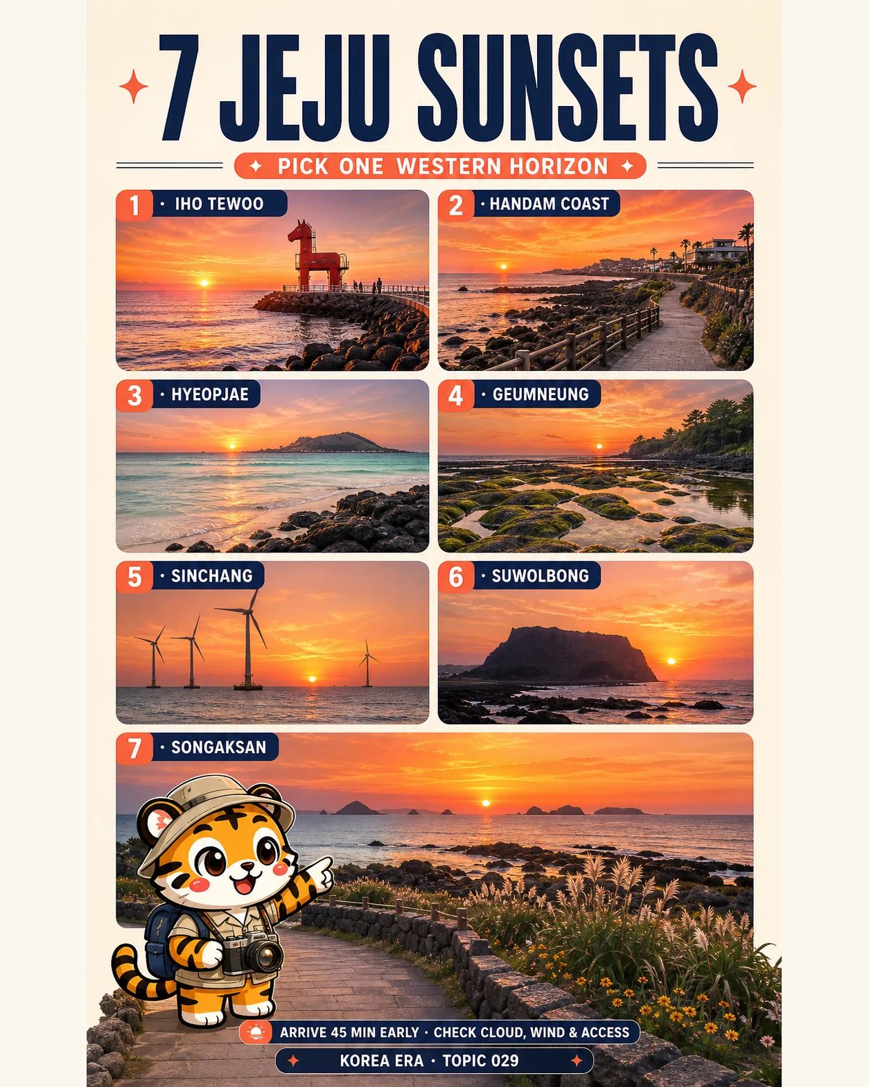
Korea Era tiger photographer below seven numbered Jeju sunset viewpoint panels
Illustrated overview · live details and sources are listed below.
TIME
Pick 1 · arrive 45 min early
BUDGET
Mostly free · transport and parking vary
BEST FOR
First sunsets · photographers · couples
MOVE
Choose one west or southwest zone

THE DESTINATION EDIT

7 destinations, each with a reason.

Choose one gateway for one day. The rail threshold is not permission to combine distant cities.
01

AIRPORT EDGE · CHOOSE 1

Pony lighthouses without a cross-island detour

Use Iho when the airport or Jeju City is already part of the day. It is the practical short-transfer choice, not a reason to squeeze sunset between bag drop and boarding.
  1. 01

    Iho Tewoo Beach

    이호테우해변

    The red and white pony lighthouses give the closest Jeju City sunset a clear foreground, while low tide can reveal traditional stone fishing walls.

    Public beach; seasonal swimming facilities and parking can differSunset viewing is not permission to swim after the managed season or lifeguard hours; keep the airport buffer separate
02

AEWOL · CHOOSE 1

A paved coast walk with an easy dinner handoff

Handam works when Aewol is already your afternoon base. Start the return before the path becomes fully dark and never treat a café seat or parking space as guaranteed.
  1. 01

    Aewol Handam Coastal Trail

    애월 한담해안산책로

    A roughly 1.2 km paved shoreline path keeps the sea close and connects the Aewol side toward Gwakji for a walk-before-sunset format.

    Public trail; cafés, parking and activities are separateWet basalt, waves, wind and darkness change the walk; turn around early enough to retrace the maintained path in usable light
03

HALLIM TWIN BEACHES · CHOOSE 1

Biyangdo foreground — lively or lower-key

Hyeopjae and Geumneung are connected twin beaches with a similar westward island silhouette. Pick the access and atmosphere that fit today; visiting both does not create a second sunset.
  1. 01

    Hyeopjae Beach

    협재해수욕장

    Pale shell sand, shallow water and Biyangdo make the horizon easy to read, with more nearby visitor services than the quieter twin.

    Open public shore; 2026 managed swimming dates and rentals are seasonalCrowds, tide, pet access and swimming controls vary; remain on the public shore and distinguish sunset viewing from water entry
  2. 02

    Geumneung Beach

    금능해수욕장

    The connected western beach adds broad low-tide sand and shallow pools beneath the same Biyangdo-facing sunset, often with a calmer layout than Hyeopjae.

    Open year-round; managed swimming facilities are seasonalLow tide is a visual option, not a safety guarantee; wear suitable footwear and return from exposed sand before darkness
04

FAR WEST · CHOOSE 1

Wind turbines or Chagwido geology

These are the exposed, far-west choices. Check cloud, wind, waves, tide and the return drive before committing; a dramatic forecast is a reason to skip, not a better photograph.
  1. 01

    Sinchang Windmill Coastal Road

    신창풍차해안도로

    Offshore turbines, an observation deck and Chagwido in the distance create the most graphic horizon of the seven.

    Open access; some sections can close at high tideThe coast can be intensely windy and wave-exposed; obey partial closures and never cross a barrier for an unobstructed frame
  2. 02

    Suwolbong Peak

    수월봉

    Suwoljeong looks west across Chagwido, while the volcanic strata make an earlier daylight arrival worthwhile before the sun drops.

    Public viewpoint; interpreter programs follow separate hoursDo not explore the lower geo trail, cliff edge or unlit shortcuts after dusk; the sunset viewpoint does not make every nearby path a night trail
05

SOUTHWEST · CHOOSE 1

Island silhouettes from the open lower coast

Use only the open lower Songaksan area and current marked paths. The summit area and summit trail are under a natural rest closure through July 31, 2027.
  1. 01

    Songaksan Mountain lower coast

    송악산 하부 해안

    Hyeongjeseom, Gapado and Marado layer the southwest horizon, while the open lower coastal area provides the relevant view without claiming summit access.

    Open areas only; follow the current closure map and signsDo not enter the closed summit area, coastal trenches or eroded cliff sections; start the return before full darkness

DESTINATION MAP

Seven Jeju sunsets — choose the horizon near you

7 destination pins
Route map · ordered stops and live map links are ready below.
AIRPORT EDGE · CHOOSE 1
AEWOL · CHOOSE 1
HALLIM TWIN BEACHES · CHOOSE 1
FAR WEST · CHOOSE 1
SOUTHWEST · CHOOSE 1
No route line is drawn between cities. Pick one destination, then check live rail and local transport before leaving.

YOUR SHORTLIST

Build a personal Chungcheong shortlist.

Mark the destinations you would actually consider. Your shortlist stays on this device.
Korea Era tiger mascot celebrating a completed route
0of 7 destinations
0%

AIRPORT EDGE · CHOOSE 1

AEWOL · CHOOSE 1

HALLIM TWIN BEACHES · CHOOSE 1

FAR WEST · CHOOSE 1

SOUTHWEST · CHOOSE 1

No account needed. This shortlist is saved only in this browser.

EDITOR’S NOTES

The choices that make this edit work.

PICK RULE

One sunset, one nearby horizon

Attach the viewpoint to the afternoon you already planned. Seven saved pins are alternatives, and west-Jeju traffic can erase the light while you chase a ranking.

Not a one-day route
LIGHT RULE

Arrive 45 minutes early

Use 45 minutes as a planning buffer for parking, walking and composition — not as an official opening time or a promise of color. Check the exact daily sunset separately.

KASI time · KMA cloud
RETURN RULE

Plan the way back before dusk

Save the Korean place name, last usable bus or taxi fallback and the maintained return path while it is still light. A sunset is not finished when the sun disappears.

Wind · access · battery

BEFORE YOU GO

What can still change

  • These are seven alternatives, not a one-day route. Choose one viewpoint near your accommodation or afternoon zone; Hyeopjae and Geumneung are connected twin-beach alternatives, not two separate sunset appointments.
  • Sunset time changes by date and exact location. Use the Korea Astronomy and Space Science Institute sunrise-and-sunset calculator for the selected address; the 45-minute arrival is this guide's planning buffer, not an official rule or visibility guarantee.
  • Check the Korea Meteorological Administration short-range forecast and warning map before moving. Cloud can erase the sun, while strong wind, wind waves, heavy rain or a typhoon can make an exposed coast unsuitable even when the sky looks dramatic.
  • No viewpoint guarantees a red sky, visible sun, low crowd, open parking, café seat or unobstructed photograph. The campaign illustration is decorative and cannot prove today's tide, cloud, path or access.
  • At Iho Tewoo, distinguish public sunset viewing from managed swimming. Seasonal beach hours, lifeguards and facilities do not make after-hours water entry safe; protect the flight instead of making this a last-minute airport stop.
  • The official Handam description gives a roughly 1.2 km paved coastal path. Allow enough light to retrace the maintained walkway, avoid wave-wet rocks and do not make a private café or activity part of the public-access promise.
  • Hyeopjae and Geumneung face Biyangdo and connect along the Hallim coast. Tide can change the visible sand and pools; choose one shore, follow seasonal swimming and pet controls, and do not walk exposed shallows into darkness.
  • Visit Jeju lists partial closure during high tide at Sinchang Windmill Coastal Road. Wind and waves can intensify on the far-west coast, so follow barriers and use a sheltered alternative instead of waiting on the over-water section.
  • Suwolbong's official sunset view is toward Chagwido from Suwoljeong. Visit the volcanic-strata trail in usable daylight only; cliffs, springs and coastal geology are not permission for an unlit after-sunset descent.
  • Songaksan's summit area and summit trail are closed through July 31, 2027 for vegetation restoration. Other open areas remain available, but current signs outrank this guide; never enter coastal trenches, eroded cliffs or a closed path.
  • Public-transport travelers should rebuild the selected sunset with the live Jeju Bus Information System and confirm the last usable connection in both directions. Keep a licensed-taxi reserve where a rural return is fragile.
  • Carry a charged phone, warm or windproof layer and a small light without using it to justify an unsafe trail. Call 112 for police, 119 for fire or medical emergency and 1330 for multilingual travel help.

USEFUL KOREAN

4 phrases for this edit

오늘 일몰은 몇 시예요?
What time is sunset today?
이 길은 지금 통행할 수 있어요?
Is this path open right now?
마지막 버스가 몇 시예요?
What time is the last bus?
바람이 강한데 여기 있어도 안전해요?
The wind is strong — is it safe to stay here?

CHECKED SOURCES

The illustration is not the source.

Changing facts are linked to the public body or tourism operator responsible for them.
  1. Official Jeju Tourism GuidebookOfficial island map, western-coast context and destination overview; live notices override the guidebook.Open official source ↗
  2. KASI · sunrise and sunset calculatorPrimary date-and-address calculator for daily sunset time; exact coordinates can produce small differences.Open official source ↗
  3. Korea Meteorological Administration · short-range forecastOfficial current cloud, precipitation and wind forecast before committing to the coast.Open official source ↗
  4. Korea Meteorological Administration · warningsOfficial heavy-rain, strong-wind, wind-wave and typhoon warnings plus criteria.Open official source ↗
  5. Visit Jeju · Iho Tewoo BeachOfficial lighthouse, low-tide wondam, coordinates and seasonal facility context.Open official source ↗
  6. Visit Jeju · Aewol Handam Coastal TrailOfficial coastal-walk description, coordinates and Aewol-to-Gwakji context.Open official source ↗
  7. Visit Jeju · Handam BeachOfficial roughly 1.2 km paved shoreline and public landscape context.Open official source ↗
  8. Visit Jeju · Hyeopjae BeachOfficial Biyangdo sunset, coordinates, twin-beach and current 2026 seasonal-operation context.Open official source ↗
  9. Visit Jeju · Geumneung BeachOfficial low-tide sand, Biyangdo sunset, coordinates and 2026 swimming-season context.Open official source ↗
  10. Visit Jeju · Sinchang Windmill Coastal RoadOfficial sunset, turbine, observation-deck, coordinates and partial high-tide closure context.Open official source ↗
  11. Visit Jeju · Suwolbong PeakOfficial Chagwido sunset, Suwoljeong, volcanic-strata and coordinates context.Open official source ↗
  12. Visit Jeju · Songaksan MountainOfficial island views, coordinates, hazards and summit closure through July 31, 2027.Open official source ↗
  13. Jeju Bus Information SystemOfficial live routes, stops, arrivals and notices for the selected return trip.Open official source ↗
  14. Korea Tourism Organization · 1330Official multilingual travel helpline and emergency-support context.Open official source ↗

NEXT EDIT

Choose another kind of day.

3 nights · 4 daysSeoul in 3 nights and 4 real days3 nights · 4 calendar daysCity dayOne first day in Seoul without crossing the city twice1 day · suggested 09:00–20:00Budget dayA full Seoul day for ₩50,0001 day · 08:30–20:30